Harrisville, West Virginia facts for kids
Quick facts for kids
Harrisville, West Virginia
|
||
|---|---|---|

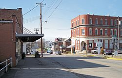
Main Street in Harrisville in 2007
|
||
|
||

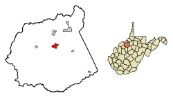
Location of Harrisville in Ritchie County, West Virginia.
|
||
| Country | United States | |
| State | West Virginia | |
| County | Ritchie | |
| Area | ||
| • Total | 1.59 sq mi (4.13 km2) | |
| • Land | 1.58 sq mi (4.10 km2) | |
| • Water | 0.01 sq mi (0.03 km2) | |
| Elevation | 856 ft (261 m) | |
| Population
(2020)
|
||
| • Total | 1,661 | |
| • Estimate
(2021)
|
1,642 | |
| • Density | 1,056.82/sq mi (408.08/km2) | |
| Time zone | UTC−5 (Eastern (EST)) | |
| • Summer (DST) | UTC−4 (EDT) | |
| ZIP Code |
26362
|
|
| Area code(s) | 304 | |
| FIPS code | 54-35428 | |
| GNIS feature ID | 1540017 | |
| Website | https://cityofharrisville.wixsite.com/mysite | |
Harrisville is a small town in West Virginia, United States. It is the main town, or county seat, of Ritchie County. You can find Harrisville where State Routes 31 and 16 meet, about five miles south of U.S. 50.
In Harrisville, you'll find an elementary school, the county's main education office, many shops, banks, and a library. It's also home to local newspapers like the Ritchie Gazette. The town has a park and is close to North Bend Golf Course, North Bend Lake, and North Bend State Park, which are great for outdoor fun. People in Harrisville vote for their town leaders every two years.
Contents
History of Harrisville
How Harrisville Started
The town of Harrisville was first planned in 1822 by Thomas Harris. He had moved his family to the area in 1807. The town officially became a town (chartered) in 1832. The first post office opened in 1833 and was called Solus.
The town's name changed a few times. It was called Ritchie Court House for a while. Then, in 1895, it was named Harrisville. This new name honored General Thomas Harris, who was the nephew of the town's founder.
Ritchie County and its Courthouse
Ritchie County was created in 1843. The first building for the county government, called a courthouse, was built in 1844. This was later replaced by a brick building in 1874. The current courthouse, which is a well-known building in Harrisville, was finished in late 1923.
Railroads and Schools
In 1875, a railroad called the Pennsboro & Harrisville Railroad was built. It connected Harrisville with another town called Pennsboro. Another railroad, the Harrisville Southern Railroad, ran to Cornwallis from about 1909 to 1929.
Harrisville High School opened in 1894. That old building is now the General Thomas M. Harris School Museum. A new high school was built in 1924. It served as Harrisville High School until 1986. Later, it became Ritchie County High School until it closed in 1994. The main school building was taken down in 2017, but a small part of it is now the Ritchie Regional Health Center. The old high school gym is still there and is used as a community workout center called "The Gym."
Important People and Places
General Thomas Harris was a very important person from Harrisville. He was a doctor and a military officer. He even helped with the trial of people involved in the assassination of President Abraham Lincoln. He passed away in 1906.
His son, John T. Harris, was also important. He started the West Virginia Blue Book in 1916, which is a guide to the state government.
Several places in Harrisville are listed on the National Register of Historic Places. This means they are important historical sites. These include the Harrisville Historic District, Harrisville Grade School, and the Ritchie County Courthouse.
The town is also home to Berdine's Five and Dime, a historic store that has been around for a long time.
Notable People
Harrisville has been the birthplace of some interesting people:
- Frank Deem (1928–2018) was born in Harrisville. He was a state legislator in West Virginia and an engineer.
- Jim Pearcy (1918–2005) was a professional football player who also came from Harrisville.
Geography
Harrisville is located at 39°12′36″N 81°3′3″W / 39.21000°N 81.05083°W.
The town covers a total area of about 1.59 square miles (4.13 square kilometers). Most of this area is land, about 1.58 square miles (4.10 square kilometers). A very small part, about 0.01 square miles (0.03 square kilometers), is water.
Demographics
| Historical population | |||
|---|---|---|---|
| Census | Pop. | %± | |
| 1870 | 140 | — | |
| 1880 | 221 | 57.9% | |
| 1890 | 361 | 63.3% | |
| 1900 | 472 | 30.7% | |
| 1910 | 608 | 28.8% | |
| 1920 | 1,036 | 70.4% | |
| 1930 | 1,192 | 15.1% | |
| 1940 | 1,338 | 12.2% | |
| 1950 | 1,387 | 3.7% | |
| 1960 | 1,428 | 3.0% | |
| 1970 | 1,464 | 2.5% | |
| 1980 | 1,673 | 14.3% | |
| 1990 | 1,839 | 9.9% | |
| 2000 | 1,842 | 0.2% | |
| 2010 | 1,876 | 1.8% | |
| 2020 | 1,661 | −11.5% | |
| 2021 (est.) | 1,642 | −12.5% | |
| U.S. Decennial Census | |||
Population Information
In 2010, there were 1,876 people living in Harrisville. These people lived in 787 households, and 496 of these were families. The town had about 1,187 people per square mile.
About 29% of the households had children under 18 living there. Many households (48%) were married couples. About 13% of households had someone living alone who was 65 years old or older.
The average age of people in Harrisville was about 44.8 years old. About 21% of the residents were under 18, and about 22% were 65 or older. Slightly more than half of the town's population (53.8%) was female, and 46.2% was male.
See also
 In Spanish: Harrisville (Virginia Occidental) para niños


