Hartford, Arkansas facts for kids
Quick facts for kids
Hartford, Arkansas
|
|
|---|---|

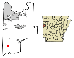
Location of Hartford in Sebastian County, Arkansas.
|
|
| Country | United States |
| State | Arkansas |
| County | Sebastian |
| Area | |
| • Total | 1.89 sq mi (4.90 km2) |
| • Land | 1.88 sq mi (4.88 km2) |
| • Water | 0.01 sq mi (0.02 km2) |
| Elevation | 637 ft (194 m) |
| Population
(2020)
|
|
| • Total | 499 |
| • Density | 264.86/sq mi (102.26/km2) |
| Time zone | UTC-6 (Central (CST)) |
| • Summer (DST) | UTC-5 (CDT) |
| ZIP code |
72938
|
| Area code(s) | 479 |
| FIPS code | 05-30490 |
| GNIS feature ID | 2403809 |
Hartford is a small city located in Sebastian County, Arkansas, in the United States. It is part of the Fort Smith, Arkansas-Oklahoma Metropolitan Statistical Area. This means it's connected to the larger Fort Smith area. In 2020, the city had a population of 499 people.
A famous clergyman named James T. Draper, Jr. was born in Hartford in 1935. His father was a pastor in the city. James T. Draper, Jr. later became the president of the Southern Baptist Convention from 1982 to 1984.
Geography
Hartford covers a total area of about 1.8 square miles (4.9 square kilometers). All of this area is land. The city offers views of both Sugarloaf and Poteau mountains.
Population Facts
| Historical population | |||
|---|---|---|---|
| Census | Pop. | %± | |
| 1900 | 460 | — | |
| 1910 | 1,780 | 287.0% | |
| 1920 | 2,067 | 16.1% | |
| 1930 | 1,210 | −41.5% | |
| 1940 | 1,189 | −1.7% | |
| 1950 | 865 | −27.2% | |
| 1960 | 531 | −38.6% | |
| 1970 | 616 | 16.0% | |
| 1980 | 613 | −0.5% | |
| 1990 | 721 | 17.6% | |
| 2000 | 772 | 7.1% | |
| 2010 | 642 | −16.8% | |
| 2020 | 499 | −22.3% | |
| U.S. Decennial Census | |||
In 2000, there were 772 people living in Hartford. These people lived in 299 households, and 217 of those were families. The population density was about 427 people per square mile.
About 30% of the households had children under 18 living with them. The average household had about 2.58 people. The average family size was about 3.05 people.
The population was spread out by age. About 26% of the people were under 18 years old. About 17.5% were 65 years or older. The average age in the city was 38 years.
History of Hartford
The town of Hartford was first known as Gwynn when it was settled. Before the year 1900, the Rock Island Railroad came to the town. Because of the railroad, the town's name was changed to Hartford.
Hartford officially became a city on February 28, 1900. There was an older settlement about a mile and a half to the west. This older place was also called Hartford, named after a creek. Today, people often call this older area "Old Town" or "West Hartford."
Early businesses in West Hartford were opened by William J. Fleming and William Stevenson. By 1891, West Hartford had several businesses. It also had a public school and a church that was used by different groups.
In 1912, Hartford made history by electing Peter Stewart as mayor. He was a miner and the first socialist mayor elected in Arkansas.
A workers' dispute happened in and around the town on July 12, 1914. This event is known as the Hartford coal mine riot.
In the early 1900s, Hartford was home to the Hartford Music Company. This company published Gospel music and ran a singing school. The city was also a place with a lot of coal mining. Today, some mining still happens. Hartford is home to the last working coal mine in Arkansas. Many farm owners in the town also have oil or gas pumps on their land.
Education
Hartford is part of the Hackett School District. Students in Hartford attend Hackett High School, which is the main high school for the district.
Before 2015, Hartford had its own school district, called the Hartford School District. Hartford High School was the high school for that district. In 2014, the Hartford district joined with the Hackett district. Hartford High School stayed open with the Hackett District until it closed in 2018. Hartford Elementary, the elementary school, also closed at that time.
West Hartford
West Hartford is a populated area located to the southwest of Hartford. It is about halfway to the Oklahoma state border. The Sebastian County Road 4G Bridge, which is listed on the National Register of Historic Places, is located nearby.
See also
 In Spanish: Hartford (Arkansas) para niños
 | Stephanie Wilson |
 | Charles Bolden |
 | Ronald McNair |
 | Frederick D. Gregory |

