Hartland (CDP), Vermont facts for kids
Quick facts for kids
Hartland, Vermont
|
|
|---|---|

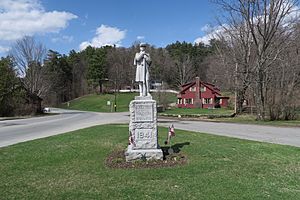
War Memorial
|
|

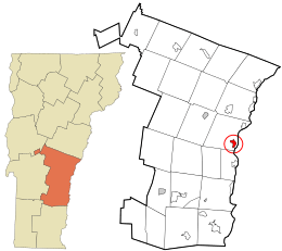
Location in Windsor County and the state of Vermont.
|
|
| Country | United States |
| State | Vermont |
| County | Windsor |
| Area | |
| • Total | 1.1 sq mi (2.8 km2) |
| • Land | 1.1 sq mi (2.8 km2) |
| • Water | 0 sq mi (0.0 km2) |
| Elevation | 587 ft (179 m) |
| Population
(2010)
|
|
| • Total | 380 |
| • Density | 351/sq mi (136/km2) |
| Time zone | UTC-5 (Eastern (EST)) |
| • Summer (DST) | UTC-4 (EDT) |
| ZIP code |
05048
|
| Area code(s) | 802 |
| FIPS code | 50-32350 |
| GNIS feature ID | 1457747 |
Hartland is a small community in Windsor County, Vermont, in the United States. It's known as a census-designated place (CDP). This means it's a special area that the government counts for population, but it's not a separate town or city.
Hartland is the main village within the larger town of Hartland. In 2010, about 380 people lived in the Hartland CDP. The whole town of Hartland had a population of 3,393 people at that time.
Where is Hartland?
Hartland is located in the eastern part of Windsor County. It sits where two important roads meet: U.S. Route 5 and Vermont Route 12.
Route 12 goes north from Hartland to a town called Woodstock. Route 5 travels north to White River Junction. Both Route 5 and Route 12 go south together towards Windsor.
There's also a big highway, Interstate 91, that runs just east of the village. You can get to Hartland from this highway using Exit 9.
See also
 In Spanish: Hartland (condado de Windsor) para niños
 | George Robert Carruthers |
 | Patricia Bath |
 | Jan Ernst Matzeliger |
 | Alexander Miles |

