Hatchet Lake Denesuline First Nation facts for kids
 |
|
| People | Denesuline |
|---|---|
| Treaty | Treaty 10 |
| Headquarters | Wollaston Lake |
| Province | Saskatchewan |
| Land | |
| Reserve(s) | |
| Land area | 110.2 km2 |
| Population (2021) | |
| On reserve | 1450 |
| Off reserve | 463 |
| Total population | 1913 |
| Government | |
| Chief | Bartholomew Tsannie |
| Tribal Council | |
| Prince Albert Grand Council | |
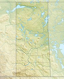
The Hatchet Lake Denesuline Nation (which they call Tthpø Tuwé) is a group of First Nations people. They are part of the Denesuline people. This community lives in northern Saskatchewan, Canada.
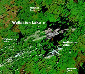
Their main home is a place called Wollaston Lake. It's a small community located right on the shores of Wollaston Lake. This area is deep within the boreal forest, which is a huge forest of evergreen trees.
The community of Wollaston Lake is actually made of two parts. There's the northern settlement of Wollaston Lake. Right next to it is Wollaston Post. This is where the Hatchet Lake Denesuline First Nation has its main offices.
Getting to Wollaston Lake is interesting! You can fly into the Wollaston Lake Airport. If you're driving, you use Highway 905. Since the highway is on one side of the big lake and the community is on the other, they have special ways to cross. In winter, they use an ice road right over the frozen lake. In summer, a special boat called the Wollaston Barge Ferry carries people and cars across.
Who Lives Here?
The Hatchet Lake Denesuline Nation is a growing community. In 2021, the main settlement of Wollaston Lake had about 96 people living there. The larger First Nations community, Wollaston Post (also known as Lac La Hache 220), had around 1,251 people in 2011.
The Hatchet Lake Dene Nation has many members. In January 2015, there were 1,760 registered members in total. Most of them, about 1,369 people, lived on their reserve land. The other 391 members lived in different places off the reserve.
How the Community is Run
Wollaston Post is the main place for the Hatchet Lake Dene Nation's government. The community chooses its leaders using their own special system. They elect one Chief and six councillors to help lead the nation.
The Hatchet Lake Dene Nation is also connected to a bigger group. They are part of the Prince Albert Grand Council. This council helps many First Nations communities work together.
Their Land
The Hatchet Lake Dene Nation has one main land area called Lac La Hache 220. This land covers a huge area of about 11,020 hectares (which is about 27,231 acres).
Their territory includes many islands in Wollaston Lake. Some of the biggest islands are Strong Island, Paul Island, Labby Island, and Jackpine Island. It also includes parts of the land around Fidler Bay and Kempton Bay.
What's the Weather Like?
Wollaston Lake has a subarctic climate. This means it has very cold and long winters. The summers are usually mild and can be quite wet.
Here's a quick look at the average temperatures and rainfall:
| Climate data for Wollaston Lake | |||||||||||||
|---|---|---|---|---|---|---|---|---|---|---|---|---|---|
| Month | Jan | Feb | Mar | Apr | May | Jun | Jul | Aug | Sep | Oct | Nov | Dec | Year |
| Mean daily maximum °C (°F) | −20.0 (−4.0) |
−15.5 (4.1) |
−8.1 (17.4) |
2.8 (37.0) |
10.8 (51.4) |
17.2 (63.0) |
20.5 (68.9) |
18.5 (65.3) |
10.9 (51.6) |
3.0 (37.4) |
−9.1 (15.6) |
−17.8 (0.0) |
1.1 (34.0) |
| Daily mean °C (°F) | −24.5 (−12.1) |
−20.5 (−4.9) |
−14.1 (6.6) |
−3.0 (26.6) |
5.3 (41.5) |
11.7 (53.1) |
15.4 (59.7) |
13.5 (56.3) |
6.8 (44.2) |
−0.4 (31.3) |
−12.7 (9.1) |
−21.9 (−7.4) |
−3.7 (25.3) |
| Mean daily minimum °C (°F) | −29.0 (−20.2) |
−25.5 (−13.9) |
−20.1 (−4.2) |
−8.7 (16.3) |
−0.1 (31.8) |
6.2 (43.2) |
10.3 (50.5) |
8.6 (47.5) |
2.8 (37.0) |
−3.7 (25.3) |
−16.3 (2.7) |
−25.9 (−14.6) |
−8.5 (16.8) |
| Average precipitation mm (inches) | 22 (0.9) |
17 (0.7) |
25 (1.0) |
29 (1.1) |
41 (1.6) |
64 (2.5) |
89 (3.5) |
68 (2.7) |
60 (2.4) |
43 (1.7) |
32 (1.3) |
24 (0.9) |
514 (20.3) |
| Source: http://en.climate-data.org/location/107968/ | |||||||||||||
See also
 | DeHart Hubbard |
 | Wilma Rudolph |
 | Jesse Owens |
 | Jackie Joyner-Kersee |
 | Major Taylor |


