Haw Knob facts for kids
Quick facts for kids Haw Knob |
|
|---|---|

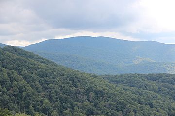
Haw Knob from the Cherohala Skyway
|
|
| Highest point | |
| Elevation | 5,472 ft (1,668 m) |
| Prominence | 192 ft (59 m) |
| Geography | |
| Location | Monroe County, Tennessee, Graham County, North Carolina, United States |
| Parent range | Unicoi Mountains |
| Climbing | |
| Access | Benton MacKaye Trail |
Haw Knob is a cool mountain found in the southeastern United States. It's part of the Unicoi Mountains range. This mountain sits right on the border between Monroe County, Tennessee and Graham County, North Carolina. It reaches a height of about 5,472 feet (or 1,668 meters) above sea level. You can find it close to the famous Cherohala Skyway, and you can even hike to it using the Benton MacKaye Trail.
Exploring Haw Knob's Location
Haw Knob is located within two large national forests. Part of it is in the Cherokee National Forest in Tennessee. The other part is in the Nantahala National Forest in North Carolina. These forests are protected areas. They are home to lots of wildlife and beautiful plants.
Getting to the Peak
The popular Cherohala Skyway road runs along the side of Haw Knob. This road offers amazing views of the mountains. However, you can't drive directly to the very top of Haw Knob. To reach the highest point, you need to hike. The Benton MacKaye Trail is a special path that leads hikers to the peak. It's a great way to explore the mountain up close.
Highest Point in Monroe County
Did you know that Haw Knob is the highest point in Monroe County, Tennessee? This means it's the tallest spot in that entire county. It stands out as a significant landmark in the area.
 | Selma Burke |
 | Pauline Powell Burns |
 | Frederick J. Brown |
 | Robert Blackburn |

