Hazel Creek (Soque River tributary) facts for kids
Hazel Creek is a cool stream in Georgia. It's like a smaller river that flows into a bigger one called the Soque River. Hazel Creek is about 13.5 miles (21.7 kilometers) long.
Where Does Hazel Creek Flow?
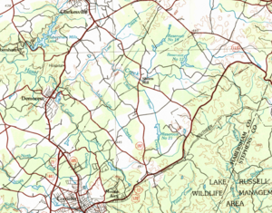
Hazel Creek starts in a tiny spot called Lake Irvin. This lake is in eastern Habersham County, Georgia. It's close to where U.S. Route 123 crosses into Stephens County, near a place called Ayersville.
From there, the creek flows west for about 4 miles. It crosses big roads like U.S. Route 23 and U.S. Route 441. Along the way, smaller streams join Hazel Creek, adding more water.
At a spot called Shorts Mill, another creek joins in. This is Little Hazel Creek, coming from the south. After this, Hazel Creek makes a sharp turn. It flows northwest for about 1.3 miles. Then, Law Creek joins it from the northeast.
Where Law Creek meets Hazel Creek, the stream turns sharply again. This time, it heads southwest, moving towards Demorest. After about a mile, Lick Log Creek flows into it. About another mile later, Camp Creek also joins Hazel Creek. Both of these creeks come from the southeast.
When Camp Creek meets Hazel Creek in Demorest Lake, the creek turns northwest once more. It winds through Demorest and continues northwest for another 3.2 miles. Finally, Hazel Creek flows into the Soque River. This meeting point is just southwest of Habersham Mills Lake.
What is a Watershed?
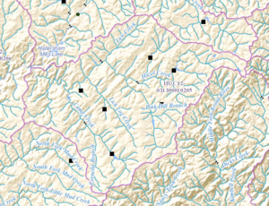
A watershed is like a big bowl or area of land. All the rain and snow that falls in this area drains into one main river or stream. So, the Hazel Creek watershed is all the land that collects water for Hazel Creek.
The United States Geological Survey (USGS) has given Hazel Creek's watershed a special code: HUC 031300010205. It's officially called the Hazel Creek sub-watershed. This area covers about 32 square miles. It's located southeast of Clarkesville and east of Demorest. It's also southeast of the Soque River itself.
 | Laphonza Butler |
 | Daisy Bates |
 | Elizabeth Piper Ensley |


