
Stephens County, Georgia facts for kids
Quick facts for kids
Stephens County
|
|
|---|---|

|
|

Location within the U.S. state of Georgia
|
|
 Georgia's location within the U.S. |
|
| Country | |
| State | |
| Founded | August 18, 1905 |
| Named for | Alexander Stephens |
| Seat | Toccoa |
| Largest city | Toccoa |
| Area | |
| • Total | 184 sq mi (480 km2) |
| • Land | 179 sq mi (460 km2) |
| • Water | 5.1 sq mi (13 km2) 2.8%% |
| Population
(2020)
|
|
| • Total | 26,784 |
| • Density | 150/sq mi (60/km2) |
| Time zone | UTC−5 (Eastern) |
| • Summer (DST) | UTC−4 (EDT) |
| Congressional district | 9th |

Stephens County is a county located in the northeastern part of Georgia. It sits in the Piedmont area, close to the Blue Ridge Mountains. The Tugaloo River and Lake Hartwell form its eastern border.
In 2020, about 26,784 people lived here. The main city and county seat is Toccoa. Toccoa is also the center of the Toccoa, Georgia area, which includes the county.
Contents
History of Stephens County
This area has a long and interesting past. Many indigenous peoples lived here for thousands of years.
Early Native American Life
Around 800 CE, people from the South Appalachian Mississippian culture built a village and a large platform mound on Tugaloo Island. This village, called Tugaloo, was used by different groups until about 1700. Many other villages also grew along the river.
The people who lived here were ancestors of the Muscogee (Creek). Later, the Yuchi people lived at Tugaloo, followed by the Cherokee people. The Muscogee Creek people controlled the southern part of the county until 1794, when they signed a treaty and gave their land to the United States.
Coming of European Settlers

After the American Revolutionary War, European Americans began to settle in this area. Many were soldiers who received land instead of pay. They moved along the Savannah River and Tugaloo River. During the American Civil War, a battle known as the Battle of the Narrows was fought here.
Stephens County was officially created on August 18, 1905. It was formed from parts of Franklin and Habersham counties. The county was named after Alexander Stephens. He was a U.S. representative, the Vice President of the Confederate States of America, and later the 53rd governor of Georgia.
Toccoa became the county seat. The first courthouse was built in 1907. It is now a historic building. A newer courthouse was built in 2000. The old courthouse is now used for county elections.
Growth and Development
Even during the Great Depression in the 1930s, more industries came to Stephens County. In 1937, J&P Coats Company bought the Capps Cotton Mill. It operated for almost 70 years. However, textile jobs later moved to other countries.
In 1938, a businessman named R.G. LeTourneau opened a factory that made earth-moving machines. The Toccoa Airport was also built that year. During World War II, the LeTourneau factory made equipment for the military, employing 2,000 people. The U.S. Army also set up Camp Toccoa here to train paratroopers.
In 1950, plans began for the Hartwell Project. This project involved building dams on the Savannah River and its branches. The dams would help control floods and create electricity. A large lake, Lake Hartwell, was also planned.
Before the area was flooded to create Lake Hartwell, experts studied ancient and historic sites in 1958. One important site was the Tugaloo Mound and village. This mound is still visible above the water today. A historic marker on Highway 123 helps people find this spot.

On November 6, 1977, the Kelly Barnes Dam broke after heavy rain. The flood rushed through the Toccoa Falls College campus. Sadly, 39 people died, and the flood caused a lot of damage.
Geography and Nature
Stephens County covers about 184 square miles. Most of this area, 179 square miles, is land. About 5.1 square miles (2.8%) is water. The county is mostly in the upper Piedmont region. The western parts have higher land and are in the foothills of the Blue Ridge Mountains.
The northern part of Stephens County is in the Tugaloo River area. This river flows into the Savannah River. Lake Hartwell was created on the Tugaloo River after the Hartwell Dam was built on the Savannah River in 1962. The southern part of the county is in the Broad River area, which also flows into the Savannah River.
Main Roads
 U.S. Route 123
 State Route 17
 State Route 17 Alternate
 State Route 63
 State Route 105
 State Route 106
 State Route 145
 State Route 184
 State Route 328
 State Route 365
Neighboring Counties
- Oconee County, South Carolina (north)
- Franklin County (south)
- Banks County (southwest)
- Habersham County (west)
Protected Areas
- Part of the Chattahoochee National Forest is in Stephens County.
People of Stephens County
| Historical population | |||
|---|---|---|---|
| Census | Pop. | %± | |
| 1910 | 9,728 | — | |
| 1920 | 11,215 | 15.3% | |
| 1930 | 11,740 | 4.7% | |
| 1940 | 12,972 | 10.5% | |
| 1950 | 16,647 | 28.3% | |
| 1960 | 18,391 | 10.5% | |
| 1970 | 20,331 | 10.5% | |
| 1980 | 21,763 | 7.0% | |
| 1990 | 23,257 | 6.9% | |
| 2000 | 25,435 | 9.4% | |
| 2010 | 26,175 | 2.9% | |
| 2020 | 26,784 | 2.3% | |
| 2023 (est.) | 27,228 | 4.0% | |
| U.S. Decennial Census 1790-1880 1890-1910 1920-1930 1930-1940 1940-1950 1960-1980 1980-2000 2010 |
|||
2020 Census Information
| Race | Number | Percent |
|---|---|---|
| White | 21,323 | 79.61% |
| Black or African American | 2,936 | 10.96% |
| Native American | 73 | 0.27% |
| Asian | 225 | 0.84% |
| Pacific Islander | 9 | 0.03% |
| Other/Mixed | 1,361 | 5.08% |
| Hispanic or Latino | 857 | 3.2% |
In 2020, there were 26,784 people living in Stephens County. There were 9,543 households and 6,783 families.
More About the People
In 2010, the county had 26,175 people. The population density was about 146 people per square mile. Most people (85.1%) were white, and 10.9% were Black or African American. About 2.4% of the population was Hispanic or Latino.
The average age of people in the county was 40.7 years. The average income for a household was $34,938. About 18.8% of the population lived below the poverty line.
Communities in Stephens County

City
- Toccoa is the main city and county seat.
Towns
Unincorporated Community
- Eastanollee is a community not officially part of a city or town.
Transportation and Media
Getting Around

The Amtrak Crescent train stops in Toccoa. This train connects Toccoa to major cities like New York, Washington, Charlotte, Atlanta, and New Orleans. The Amtrak station is at 47 North Alexander Street. The train tracks are also used by the Norfolk Southern Railway.
The Toccoa Airport is a small airport northeast of the town. It is sometimes called R.G. LeTourneau Field because R.G. LeTourneau built it.
News and Radio
The local newspaper, The Toccoa Record, started in 1873.
WNEG (AM) and 93.1 FM is a radio station that broadcasts from Toccoa. It began broadcasting in 1956.
Images for kids
-
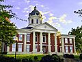
Stephens County Courthouse in Toccoa
-
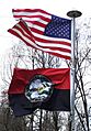
Under the USA flag is the Stephens County, GA flag.
-
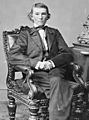
Alexander Stephens, namesake of Stephens County
-
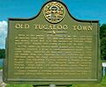
Historic Plaque Tugaloo Town, Georgia, USA
-
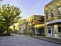
Downtown Toccoa
-
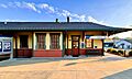
Toccoa Amtrak Station
See also
 In Spanish: Condado de Stephens (Georgia) para niños
