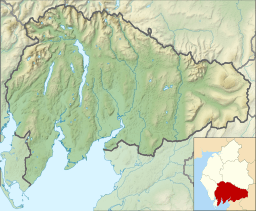
Heights Tarn facts for kids
Quick facts for kids Heights Tarn |
|
|---|---|
| Location | Lake District of Cumbria, England |
| Coordinates | 54°17′17″N 2°55′18″W / 54.28806°N 2.92167°W |
| Basin countries | England |
| Max. length | 290 m (950 ft) |
| Max. width | 73 m (240 ft) |
| Surface area | 1.5 ha (3.7 acres) |
| Surface elevation | 208 m (682 ft) |
Heights Tarn is a small, peaceful lake located in the beautiful Lake District of Cumbria, England. It sits to the east of the much larger Windermere lake and north of Simpson Ground Reservoir. This little tarn is also quite close to the village of Cartmel Fell.
About Heights Tarn
Heights Tarn is a small body of water that is often called a "tarn." A tarn is a mountain lake or pond, usually formed in a hollow created by a glacier. This particular tarn is found at an altitude of about 208 meters (which is about 682 feet) above sea level.
Size and Features
The lake covers an area of about 1.5 hectares (which is roughly 3.7 acres). It measures approximately 290 meters (about 951 feet) long and 73 meters (about 240 feet) wide. Even though it's quite close to a main road, Heights Tarn is on private land. This means it's not open for everyone to visit. On its eastern side, there is a small boathouse.
Nearby Tarns
Just about 400 meters (or 1,312 feet) to the south of Heights Tarn, you can find another small lake called Sow How Tarn. The Lake District is famous for its many tarns and lakes, each with its own unique charm.
The Lake District National Park
Heights Tarn is part of the stunning Lake District National Park, which is a very special place in England. This national park is known for its amazing mountains, valleys, and, of course, its many lakes and tarns. It's a popular spot for hiking, enjoying nature, and exploring the outdoors. The park is also a UNESCO World Heritage Site, recognized for its beautiful landscape and cultural importance.
 | William M. Jackson |
 | Juan E. Gilbert |
 | Neil deGrasse Tyson |


