Heights of Guan facts for kids

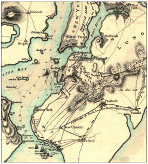
The Heights of Guan is another name for the Gowanus hills. These hills form a ridge along the western part of Long Island in New York. They stretch from Bay Ridge, Brooklyn towards the northeast.
The hills are usually between 100 and 150 feet (30-45 meters) high. The side facing south drops steeply, while the back side slopes more gently. This ridge was formed by the Wisconsin Glacier. South of the ridge, the land is flat and leads to the Atlantic Ocean.
Contents
The Heights of Guan and the American Revolution
During the American Revolution, these hills were very important. They played a key role in the Battle of Brooklyn. The ridge was a natural defense line. Its steep southern slope and thick woods made it hard for enemies to attack from the south.
There were four main paths, or "passes," through the Heights of Guan:
What Was the Gowanus Pass?
The Gowanus Pass was a path where about 7,000 British troops attacked 2,000 American soldiers. This attack was led by General James Grant against troops under Lord Stirling. This happened after an early fight at the Red Lion Inn.
What Was the Flatbush Pass?
The Flatbush Pass, also called Battle Pass, was where the Flatbush Road cut through the hills. American soldiers had cut down a large oak tree, known as the Dongan Oak. They used it to block the road and the pass. Today, this spot is inside Prospect Park. 40°39′57″N 73°57′59″W / 40.6658°N 73.9664°W
What Was the Bedford Pass?
The Bedford Pass was another important path. The American troops defending this pass had to retreat. They moved towards the Battle Pass after the British went around their side. Today, this pass is a small street called Clove Road.
How Was the Jamaica Pass Used?
The Jamaica Pass was a lightly guarded path on the Jamaica road. The British used this pass to go around the American forces. They captured four American horsemen who were on guard.
General Howe, the British commander, forced a local man named William Howard and his 14-year-old son to help him. Howard owned a tavern on the Jamaica Road. They showed Howe an old Native American trail called the Rockaway Path. This trail went around the pass itself. Today, this area is part of the Evergreen Cemetery.
Life After the War
After the American Revolution, the area around the Heights of Guan grew slowly at first. However, roads improved over time. By the mid-1800s, cities started to spread out. This led to urban sprawl.
Various railroads, like the South Brooklyn Railway, were built across the Heights. Two large reservoirs, Prospect Reservoir and Ridgewood Reservoir, were also built here. They supplied water to the growing City of Brooklyn. Later, Eastern Parkway was built along the top of the ridge, connecting the reservoirs.
Neighborhoods like Park Slope and Crown Heights became popular places to live. Many people who worked in the city moved to these areas.
 | Aaron Henry |
 | T. R. M. Howard |
 | Jesse Jackson |

