Heirisson Island facts for kids

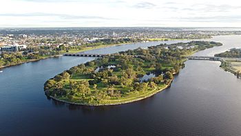
Heirisson Island from the air with South Perth in the background
|
|
| Geography | |
|---|---|
| Location | East Perth, Western Australia |
| Coordinates | Lua error in Module:Coordinates at line 614: attempt to index field 'wikibase' (a nil value). |
| Adjacent bodies of water | Swan River |
| Area | 285,600 m2 (3,074,000 sq ft) |
| Administration | |
|
Australia
|
|
| State | Western Australia |
| City | City of Perth |
| Suburb | East Perth |
| Additional information | |
| Time zone | |
Heirisson Island is a special island in the Swan River in Western Australia. It's located at the eastern end of Perth Water. You can find it between the suburbs of East Perth and Victoria Park.
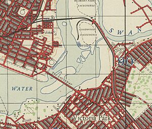
The island covers an area of about 285,600 square meters. It is connected to the land on both sides by The Causeway. Soon, new pedestrian and cyclist bridges will also link to it. Heirisson Island is the last island you'll find in the Swan River before it reaches the Indian Ocean.
Long ago, this area was made up of several small islands and muddy areas. Over time, people used dredging and land reclamation to create one larger island. Today, it is a beautiful nature reserve with a 2-kilometer walking path. The local Aboriginal people, the Noongar, call this area Matagarup, which means "leg deep." This name is still used for the island. Heirisson Island is officially listed as an important Aboriginal heritage site.
Contents
Island's Past: A Journey Through Time
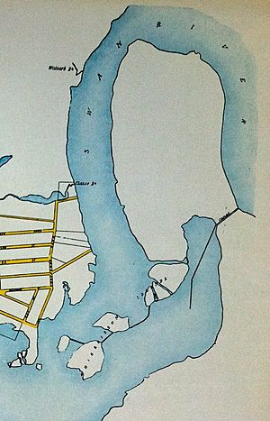
Heirisson Island wasn't always one big island. It used to be six smaller islands surrounded by mudflats. By the 1940s, people started dredging the Swan River. This means they dug up the riverbed to make it deeper. They also reclaimed land, which means they filled in muddy areas. These actions joined the small islands into the single large island we see today.
Aboriginal Connections to the Land
The land around Heirisson Island has a deep history with the Beeloo people. They are a group of the Whadjuk Noongar people. They called the small islands and mudflats Matagarup. This name described how the river was "one leg deep" in that area. Another island near where the causeway bridge is now was called Kakaroomup.
The Matagarup mudflats were a very important crossing point. It was the first major place to cross the river upstream from its mouth at Fremantle. The Beeloo people would allow other Aboriginal groups to cross the river here.
Early European Explorers
The first European to visit the Heirisson Island area was a Dutch explorer named Willem de Vlamingh. He came in January 1697. He tried to explore the Swan River in small boats. However, he could only get as far as the mudflats near Heirisson Island. The mud stopped his boats from going any further.
The island was later named after a French sailor, François-Antoine Boniface Heirisson. He was part of a scientific trip on the ship Le Naturaliste between 1801 and 1804. This expedition explored the river and made the first maps of the Swan River. They named the islands in June 1801. Later, in 1827, Captain James Stirling explored the area. This was just before the Swan River Colony was started in 1829.
Island's Changing Uses
Before it became a nature reserve, the islands had a small, informal settlement. Animals were also seen grazing there as late as the 1920s. In the late 1940s, there were plans to build a huge sports complex on the island. It was supposed to have an athletics stadium, an Olympic swimming pool, and many tennis courts. However, these plans were too expensive and were eventually dropped.
Over the years, many other ideas for the island came up. These included a motel, a golf course, a caravan park, and a cultural center. In 1966, there was even a proposal to turn Heirisson Island into a small airport for special aircraft. There were also plans to fill in part of the river to connect the island directly to East Perth.
In September 1984, a statue of the Aboriginal warrior Yagan was placed on the island. This statue was unfortunately damaged by vandals in 1997.
Wildlife: Kangaroos on the Island
In 1998, five female western grey kangaroos were brought to Heirisson Island. Two years later, in 2000, another female kangaroo with a baby male joey joined them. These kangaroos now live freely on the island. They are a popular sight for visitors.
Future Plans and Community Voices
In 2008, the City of Perth created a new plan for Heirisson Island. This plan suggested building a sculpture park with artworks from around the world. It also proposed an outdoor theater and a new footbridge. This bridge would connect Point Fraser to Heirisson Island. However, some Aboriginal elders did not agree with parts of this plan. As of late 2022, the sculpture park and theater have not been built.
In December 2022, a new project was approved. This project involves building the Causeway Pedestrian and Cyclist Bridges. These bridges will connect Point Fraser and McCallum Park to Heirisson Island. Construction on this $100 million bridge project began in November 2023. It is expected to open in late 2024.
Community Protests on the Island
Heirisson Island has been a place for protests by Aboriginal activists. These protests aim to raise awareness about important issues.
Protecting Native Title
In 2012, a group of Noongar people set up a temporary protest area on the island. They called it a "tent embassy." Their goal was to make people aware of problems with a government plan. This plan would affect the native title land of the Noongar people. Native title means the traditional rights and interests of Aboriginal and Torres Strait Islander people in land and waters. The "tent embassy" was a peaceful way to show their connection to Noongar country. It was inspired by a similar protest in Canberra. The protest area was later removed by police in March 2012.
Concerns for Communities
In early 2015, another group of Aboriginal activists set up a temporary living area. This happened after the state government announced plans to close some remote Western Australian Aboriginal communities. The group called their camp a "refugee camp." City of Perth rangers, with police help, removed the camp after ten days. However, it was gradually set up again. By late April 2015, about 100 people were staying there when it was again removed by police and rangers.
In January 2016, about 60 people, including some non-Indigenous homeless people, were camping on the island again. By April 2016, the camp had grown to over 100 people. It was once more removed by police and rangers.
 | Aaron Henry |
 | T. R. M. Howard |
 | Jesse Jackson |


