Hendron, Kentucky facts for kids
Quick facts for kids
Hendron, Kentucky
|
|
|---|---|

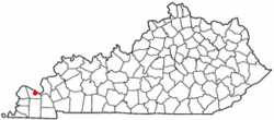
Location in Kentucky
|
|
| Country | United States |
| State | Kentucky |
| County | McCracken |
| Area | |
| • Total | 5.37 sq mi (13.91 km2) |
| • Land | 5.35 sq mi (13.85 km2) |
| • Water | 0.02 sq mi (0.06 km2) |
| Elevation | 367 ft (112 m) |
| Population
(2020)
|
|
| • Total | 4,774 |
| • Density | 892.50/sq mi (344.63/km2) |
| Time zone | UTC-6 (Central (CST)) |
| • Summer (DST) | UTC-5 (CDT) |
| ZIP code |
42003 (Paducah)
|
| Area code(s) | 270 & 364 |
| FIPS code | 21-35902 |
| GNIS feature ID | 0494048 |
Hendron is a community in McCracken County, Kentucky, United States. It is known as a census-designated place (CDP). This means it's a specific area used for counting people by the government, even though it doesn't have its own city government.
In 2020, about 4,774 people lived in Hendron. The community is part of the larger Paducah metropolitan area, which includes parts of Kentucky and Illinois.
Contents
History of Hendron
The community of Hendron got its name from a local family called the Hendron family.
Geography of Hendron
Hendron is located in western Kentucky. Its exact coordinates are 37°2′16″N 88°38′42″W. The community is right next to the southern edge of the city of Paducah.
The original part of Hendron is in the northeast section of the CDP. This area is near Old Mayfield Road, just north of where it crosses Interstate 24. The Hendron CDP stretches west to U.S. Route 45 and south to Yopp Lane. This area is between South Friendship Road and Old Highway 45.
Hendron shares borders with other communities. To its west is the CDP of Massac. Also, the community of Lone Oak along US 45 is split between Hendron and Massac.
According to the United States Census Bureau, the total area of Hendron is about 5.37 square miles (13.91 square kilometers). Most of this area is land. Only a small part, about 0.02 square miles (0.06 square kilometers), is water.
Population and People
The population of Hendron has changed over the years. Here's how many people lived there during different census counts:
| Historical population | |||
|---|---|---|---|
| Census | Pop. | %± | |
| 1990 | 3,712 | — | |
| 2000 | 4,239 | 14.2% | |
| 2010 | 4,687 | 10.6% | |
| 2020 | 4,774 | 1.9% | |
| U.S. Decennial Census | |||
In 2000, there were 4,239 people living in Hendron. These people lived in 1,832 households, and 1,278 of these were families. The population density was about 816.7 people per square mile. There were also 1,932 housing units, which are homes or apartments.
Most of the people in Hendron in 2000 were White (95.59%). There were also smaller groups of African American (2.24%), Native American (0.26%), and Asian (0.66%) residents. About 1.25% of the population identified as Hispanic or Latino.
About 28.5% of households had children under 18 living with them. More than half (56.6%) were married couples living together. About 9.4% of households were led by a female without a husband present.
The average household had 2.30 people, and the average family had 2.76 people.
The population was spread out by age:
- 21.5% were under 18 years old.
- 7.7% were between 18 and 24 years old.
- 28.0% were between 25 and 44 years old.
- 26.6% were between 45 and 64 years old.
- 16.2% were 65 years old or older.
The average age in Hendron in 2000 was 41 years. For every 100 females, there were about 91.3 males.
The median income for a household in Hendron was $40,858. For families, the median income was $49,401. The average income per person was $22,984. A small percentage of families (3.8%) and individuals (7.0%) lived below the poverty line. This included 9.6% of those under 18 and 9.2% of those 65 or older.
Education in Hendron
The main office for McCracken County Public Schools (MCPS) is located in Hendron. This school district is responsible for all public schools in McCracken County, except for those within the city of Paducah itself.
See also
 In Spanish: Hendron (Kentucky) para niños
 | Valerie Thomas |
 | Frederick McKinley Jones |
 | George Edward Alcorn Jr. |
 | Thomas Mensah |

