Lone Oak, Kentucky facts for kids
Quick facts for kids
Lone Oak, Kentucky
|
|
|---|---|

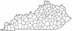
Location of Lone Oak, Kentucky
|
|
| Country | United States |
| State | Kentucky |
| County | McCracken |
| Area | |
| • Total | 0.3 sq mi (0.7 km2) |
| • Land | 0.3 sq mi (0.7 km2) |
| • Water | 0.0 sq mi (0.0 km2) |
| Elevation | 472 ft (144 m) |
| Population
(2000)
|
|
| • Total | 454 |
| • Density | 1,782.2/sq mi (688.1/km2) |
| Time zone | UTC-6 (Central (CST)) |
| • Summer (DST) | UTC-5 (CDT) |
| ZIP code |
42001
|
| Area code(s) | 270 & 364 |
| FIPS code | 21-47512 |
| GNIS feature ID | 0496999 |
Lone Oak is a small community in McCracken County, Kentucky, United States. It used to be a city, but it is now an unincorporated community. This means it doesn't have its own city government anymore. In 2000, 454 people lived there. Lone Oak is part of the larger Paducah metropolitan area.
Contents
History of Lone Oak
Learn how Lone Oak got its unique name and what happened to its city government.
How Lone Oak Got Its Name
In 1875, this area was first called "Pepper's Mill." It was named after Dr. W.T. Pepper, who lived there early on. He built a gristmill (a mill for grinding grain) near where Lovelaceville Road and US Highway 45 meet today.
In 1900, when they wanted to open a post office, the name "Pepper's Mill" was not approved. So, they chose "Lone Oak" instead. This name came from a very large oak tree that stood right at that same intersection.
Sadly, the famous oak tree was cut down in 1903 to be used for a Christmas bonfire. Today, a special historical marker shows where the tree once stood.
Lone Oak Becomes an Unincorporated Community
On November 4, 2008, the people of Lone Oak voted to dissolve their city government. The vote was 75 in favor and 64 against. This meant that Lone Oak would no longer be an official city.
When the city was dissolved, all the local government jobs, like the mayor, city council members, and police, were ended. Even though it's not a city anymore, people still call the area the community of Lone Oak. This change officially happened 30 days after the vote.
Geography of Lone Oak
Find out where Lone Oak is located and what its surroundings are like.
Location and Boundaries
Lone Oak is located at 37°2′10″N 88°39′58″W / 37.03611°N 88.66611°W. The area that used to be the city is now split between two other places: Hendron to the east and Massac to the west. U.S. Route 45, also known as Lone Oak Road, acts as the boundary between these two areas.
The city limits of Paducah touch what was once the northeast corner of Lone Oak. Downtown Paducah is about 5 miles (8 km) to the northeast. Mayfield is about 21 miles (34 km) south if you take US 45.
Land Area
According to the United States Census Bureau, the former city of Lone Oak covered a total area of about 0.2 square miles (0.7 square kilometers). All of this area was land, with no water.
Population and People
Discover information about the people who live in Lone Oak.
Population in 2000
In the year 2000, there were 454 people living in Lone Oak. These people lived in 220 different households, and 128 of these households were families.
The population density was about 1,782 people per square mile (688 people per square kilometer). This tells us how many people lived in each part of the area. There were also 250 housing units, which are places where people can live.
Who Lives in Lone Oak?
Most of the people living in Lone Oak in 2000 were White (about 93.8%). There were also smaller groups of African Americans (1.8%), Asians (0.2%), and people from other races (2.6%). About 1.5% of the population identified with two or more races. Around 4.2% of the population were Hispanic or Latino.
Households and Families
Out of the 220 households in Lone Oak:
- About 22.3% had children under 18 living with them.
- 41.4% were married couples living together.
- 10.5% had a female head of household with no husband present.
- 41.8% were non-family households (meaning people living alone or with roommates, not related as a family).
About 38.2% of all households were made up of individuals living alone. And 17.3% of households had someone aged 65 or older living by themselves. The average household had about 2.06 people, and the average family had about 2.68 people.
Age and Income
The median age of people in Lone Oak in 2000 was 40 years old. This means half the people were younger than 40 and half were older.
- 17.4% of the population was under 18 years old.
- 12.1% was between 18 and 24 years old.
- 31.1% was between 25 and 44 years old.
- 20.3% was between 45 and 64 years old.
- 19.2% was 65 years or older.
The median income for a household in the city was $31,250 per year. For a family, the median income was $35,938 per year. The average income per person was $17,512. About 15.3% of the population, including 20.4% of those under 18, lived below the poverty line.
 | Roy Wilkins |
 | John Lewis |
 | Linda Carol Brown |

