Henley Cay facts for kids

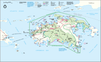
Map of the Virgin Islands National Park with Henley Cay in the northwest.
|
|
| Geography | |
|---|---|
| Location | Caribbean Sea |
| Coordinates | 18°21′12″N 64°47′36″W / 18.3534°N 64.7932°W |
| Administration | |
| Federal Department | U.S. Department of the Interior |
| Federal Agency | U.S. Fish and Wildlife Service |
| Capital city | Washington, D.C. |
| Largest settlement | New York City |
| President | Donald John Trump |
Henley Cay, once called Women's Cay, is a small, beautiful tropical island in the United States Virgin Islands. It covers about 11 acres, which is roughly the size of 11 football fields. This little island is known for its clear waters and sandy beaches.
Henley Cay is a popular spot for fun activities like snorkeling and kayaking. It's a great place to explore the ocean and relax in nature. Even though it has a pier, no one lives on Henley Cay.
Contents
Discover Henley Cay
Henley Cay is a special place in the Caribbean Sea. It's part of the Virgin Islands National Park, which helps protect its amazing natural environment. This makes it a safe home for many plants and animals.
Where is Henley Cay?
Henley Cay is located in the United States Virgin Islands. It's about 300 yards wide and is the biggest of the Durloe Cays. You can find it northwest of Turtle Bay on the island of Saint John.
The Durloe Channel separates Henley Cay from Saint John. The island rises about 70 feet above the sea. Its location makes it easy to visit from nearby larger islands.
Fun Things to Do
Henley Cay is a fantastic destination for outdoor adventures. Many people visit to enjoy the clear blue waters and the peaceful surroundings. It's a perfect spot for a day trip.
Snorkeling Adventures
The waters around Henley Cay are perfect for snorkeling. You can see colorful coral reefs and many different kinds of fish. It's like swimming in a giant aquarium! The water is usually calm and clear, making it easy to spot marine life.
Kayaking Fun
Kayaking is another popular activity at Henley Cay. You can paddle around the island and explore its coastline. Some companies offer guided kayak tours from places like Cruz Bay, Honeymoon Bay, and Caneel Bay. These tours often include visits to Henley Cay and Lovango Cay.
Relaxing on the Beach
Henley Cay also has beautiful white sandy beaches. These beaches are great for relaxing in the sun or building sandcastles. The calm waters near the shore are perfect for a swim. It's a peaceful escape from busy life.
Protecting Henley Cay
Because Henley Cay is part of the Virgin Islands National Park, it is protected. This means that its natural beauty and wildlife are kept safe for everyone to enjoy. The park helps to preserve the coral reefs and the animals that live there. This protection ensures that future generations can also experience the wonders of Henley Cay.
 | Lonnie Johnson |
 | Granville Woods |
 | Lewis Howard Latimer |
 | James West |


