Virgin Islands National Park facts for kids
Quick facts for kids Virgin Islands National Park |
|
|---|---|
|
IUCN Category V (Protected Landscape/Seascape)
|
|
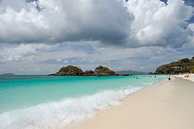
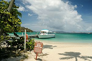
Trunk Bay
|
|
| Location | United States Virgin Islands |
| Nearest city | Charlotte Amalie |
| Area | 14,737 acres (59.64 km2) |
| Established | August 2, 1956 |
| Visitors | 112,287 (in 2018) |
| Governing body | National Park Service |
| Website | Virgin Islands National Park |
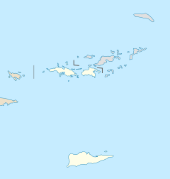
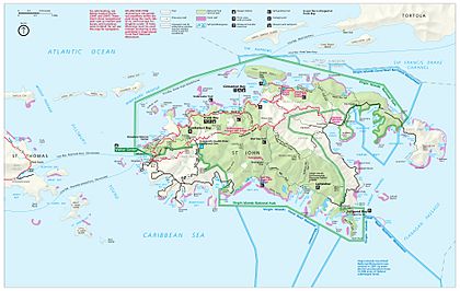
The Virgin Islands National Park is a special place in the United States Virgin Islands. It protects about 60% of the land on Saint John island. It also includes over 5,500 acres (2,226 ha; 9 sq mi) of the ocean nearby. Plus, almost all of Hassel Island is part of the park. This island is close to Charlotte Amalie on Saint Thomas.
This park is famous for amazing scuba diving and snorkeling adventures. You can also explore miles of hiking trails through the beautiful tropical rainforest.
Cruz Bay is the main entry point to the park. Boats called ferries travel there often from other islands. You can catch a ferry from Red Hook on St. Thomas every hour. Ferries also come from Charlotte Amalie, St. Thomas, and West End, Tortola. There are also ferries from Jost Van Dyke and Virgin Gorda.
The Virgin Islands National Park visitor center is located in Cruz Bay. It's a great place to start your visit.
In September 2017, two very strong hurricanes, Irma and Maria, hit the Virgin Islands. The park had fewer visitors in 2018 (112,287) compared to previous years. Before the hurricanes, it usually welcomed over 450,000 visitors each year. The park worked hard to reopen quickly. By December 2017, all roads, trails, and beaches were ready for visitors again.
Contents
History of Virgin Islands National Park
The park was created in 1956 thanks to Laurance Rockefeller. His organization, Jackson Hole Preserve, gave a lot of land on St. John to the National Park Service. They had one important rule: the land had to be protected forever from new buildings. A part of this land, the Caneel Bay Resort, still operates there. It has a special agreement with the National Park Service, which owns the land.
The park's official boundaries cover about 75% of St. John island. However, some private lands are inside these boundaries. This means the park actually owns about 60% of the island's land.
A large part of the island's waters, coral reefs, and shorelines are protected within the park. This protection grew even more in 2001. That's when the Virgin Islands Coral Reef National Monument was created to save more of the underwater world.
In 2006, a group called The Trust for Public Land bought a large area called Estate Maho Bay. This 415-acre (167.9 ha) property has beaches, untouched forests, and old artifacts. These artifacts are from Danish colonial times and the Taíno people. The trust plans to sell this land to the National Park Service when money is available. In 2011, they gave 18 acres at Mamey's Peak to the park. In 2012, the National Park Service bought 58 acres for $2.25 million. This money came from a special fund for land and water conservation. In 2013, another 72 acres of Estate Maho Bay were sold to the park for $2.5 million. This was the biggest addition to the park's land.
Fun Things to Do in the Park
The main reasons people visit the park are its beautiful beaches, colorful coral reefs, exciting hiking trails, and amazing natural spots.
You can find many places to stay near the park on St. John. These include resorts, hotels, and vacation homes. Inside the park, you can camp at Cinnamon Bay Campground. The Caneel Bay Resort, once Laurance Rockefeller's personal property, also offers places to stay on the north shore. If you have a boat, you can use special mooring balls for overnight or day use.
Amazing Beaches to Explore
The beaches in Virgin Islands National Park are often called some of the best in the world.
Trunk Bay Beach
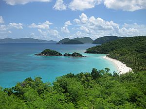
Trunk Bay is a famous beach and bay on Saint John. It has a special underwater trail for snorkeling. You can follow this trail to see the amazing coral reef. The beach has two parts: the main Trunk Bay beach and a smaller area called Burgesman Cove.
Cinnamon Bay Beach
Cinnamon Bay beach is a long, wide sandy beach on the north side of St. John. It's a great place for sunbathing, snorkeling, and water sports. The Cinnamon Bay Campground is also located here, and you can rent water sports equipment.
Honeymoon Beach
Honeymoon Beach is on the north shore of St. John. You can reach it by hiking the 1 mile (1.6 km) Lind Point Trail from Cruz Bay. Or, you can get there from Caneel Bay Resort. This beach has soft white sand and tall palm trees. You can rent kayaks and snorkel gear here.
Maho Bay Beach
Maho Bay is known for its soft sand and calm, shallow water. The sandy and seagrass bottom makes it a perfect spot to see sea turtles and stingrays swimming around.
Salt Pond Bay Beach
Salt Pond Bay is on St. John's south shore. It's a protected bay and beach. You can get there by hiking a short trail from Route 107. This is about 4 miles (6.4 km) south of Coral Bay. It's a popular place for snorkeling. You'll find reefs on both sides of the bay and seagrass in the middle. Boaters can use mooring balls here. From Salt Pond Bay, you can also hike to Drunk Bay and the Ram Head Trail.
Exciting Hiking Trails
The Cinnamon Bay Nature Trail takes you past old sugar plantation ruins. The Bordeaux Mountain Trail leads to the highest point on the island. It's 1,277 feet (389 m) above sea level.
Reef Bay Trail
The Reef Bay Trail offers amazing views of forests and old sugar mills. You can also see historical Taíno rock carvings called petroglyphs. There's a spring-fed waterfall and a calm pool. You can even snorkel over the coral reef at Genti Bay. This hike is challenging, and the round trip is more than 6 miles (9.7 km). You can join a ranger-guided hike. This hike includes a boat ride back to Cruz Bay from Reef Bay.
Bordeaux Mountain Trail
The Bordeaux Mountain Trail is a steep and rocky path. It goes from Little Lameshur Bay to the highest point on the island. This trail is not maintained, so it can be rough. While there are some viewpoints, the very top is covered in dense forest, so there's no view from there. The trail climbs almost 1,300 feet (396 m) in about 1 mile (1.6 km).
Lind Point Trail
The 1 mile (1.6 km) Lind Point Trail starts in Cruz Bay. It's right behind the Virgin Islands National Park Visitor Center. The trail goes up to Lind Point, where you can see Cruz Bay harbor. It then continues to Honeymoon Beach.
Caneel Hill Trail
The Caneel Hill Trail also starts in Cruz Bay, just north of Mongoose Junction. It's a steep climb to the top of Caneel Hill. At the summit, there's a wooden platform. From here, you get amazing views of St. John, St. Thomas, Jost Van Dyke, and many smaller islands. On a clear day, you might even see St. Croix and Puerto Rico.
Ram Head Trail
The Ram Head Trail begins at Salt Pond Bay. It travels about 1 mile (1.6 km) along a dry, rocky peninsula. This trail leads you to the southernmost point on St. John.
Cinnamon Bay Nature Trail and Boardwalk
Across from the Cinnamon Bay Campground entrance is the Cinnamon Bay Nature Trail. It's a 0.5-mile (0.8 km) loop that winds through the ruins of an old sugar factory. Signs along the path explain the history of the area. The trail has boardwalks and paved paths, with no steep hills, making it easy to walk.
Historic Places to Visit
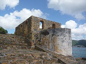
The park protects many historic ruins. These are from the time when the islands were colonies and had plantations. Some date back to the 1950s.
Annaberg Historic District
The Annaberg Historic District protects a partly restored sugar factory and windmill. It's located just east of Mary's Point. Signs from the National Park explain how sugar cane was turned into molasses. Park rangers and volunteers are often there to answer your questions. The bake house sometimes has cooking demonstrations. They even offer samples of a local bread called dumb bread. The windmill is on Annaberg Point. From there, you can see Tortola, Great Thatch Island, and the Narrows.
Reef Bay Sugar Factory Historic District
The ruins of the Reef Bay Sugar Factory Historic District can be reached by hiking the Reef Bay Trail or the L'Esperance trail.
Petroglyph Site
The Reef Bay Trail petroglyphs are ancient Taíno rock carvings. They are found on rocks near a waterfall. You can reach them by taking a 0.25-mile (0.4 km) side trail from the Reef Bay Trail. This petroglyph site was added to the National Register of Historic Places in 1982.
Catherineberg Sugar Mill Ruins
The Catherineberg Sugar Mill Ruins are very well preserved. They are also some of the easiest ruins to reach in the park. They include a windmill tower and a horse mill.
Park Geography and Wildlife
Virgin Islands National Park covers 14,737 acres (5,964 ha; 23 sq mi) of land and ocean. It includes almost 60 percent of St. John Island, the ocean nearby, and nearly all of Hassel Island.
The main features of the park are its coral reefs, which almost completely surround it. There are also beautiful ocean waters, tropical forests, and sandy beaches. Many animals live in the park. You might see wild donkeys, deer, mongoose, pigs, goats, and many kinds of birds. There are also iguanas, skinks, tortoises, frogs, and crabs. Bats are the only native land mammals in the park.
Important Bird Area
The park is recognized as an Important Bird Area (IBA) by BirdLife International. This means it's a vital place for many bird species. It helps protect birds like bridled quail-doves, green-throated caribs, Antillean crested hummingbirds, brown pelicans, Caribbean elaenias, Puerto Rican flycatchers, pearly-eyed thrashers, and Lesser Antillean bullfinches.
Park Climate
Virgin Islands National Park has a tropical climate. This means it's warm all year round. The average temperature for the park is 79 °F (26 °C). It also gets a lot of rain, about 55 inches (1,400 mm) per year. There is a dry season, which is usually from December to April. During the winter, steady winds called trade winds blow from 11 knots (13 mph; 20 km/h) to 21 knots (24 mph; 39 km/h).
The temperature doesn't change much between summer and winter. The ocean water stays warm all year. The busiest time for visitors is from December to April, which are the driest months. During the rest of the year, which is the Atlantic hurricane season, prices for places to stay are often lower. You can camp or stay in rustic cabins at Cinnamon Bay Campground from November through August. Caneel Bay Resort offers luxury stays and dining from November through July.
How the Island Was Formed (Geology)
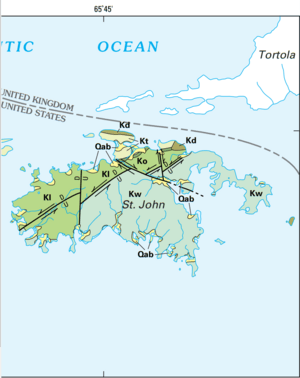
St. John is located at the eastern end of the Greater Antilles islands. It sits on the northeastern edge of the Caribbean Plate. The island began forming a very long time ago, during the Cretaceous period. It started with volcanic eruptions that created rocks like keratophyres and pillow basalts. Later, the volcanic activity changed, forming rocks like andesite and basalt. Then, there was a time when limestone was deposited.
Volcanic activity started again, forming more rocks from volcanic ash and lava. After this, a group of rock formations called dikes formed. Then, the Caribbean Plate pushed against another landmass, causing the island's rocks to fold. Later, more molten rock pushed into the island, and more folding happened. This folding is also linked to movements along faults, which are cracks in the Earth's crust.
See also
 In Spanish: Parque nacional Islas Vírgenes para niños
 | James B. Knighten |
 | Azellia White |
 | Willa Brown |


