Virgin Gorda facts for kids

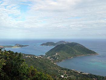
Overlooking the North Sound, 2010
|
|
|
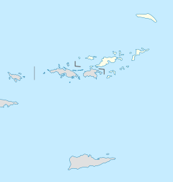
The location of Virgin Gorda within the British Virgin Islands
|
|
| Geography | |
|---|---|
| Location | Atlantic Ocean |
| Coordinates | 18°28′55″N 64°23′25″W / 18.48194°N 64.39028°W |
| Archipelago | Virgin Islands |
| Administration | |
|
United Kingdom
|
|
| British Overseas Territory | British Virgin Islands |
| Demographics | |
| Population | 3,930 (2010) |
| Additional information | |
| Time zone | |
| ISO code | VG |
Virgin Gorda is a beautiful island in the British Virgin Islands (BVI). It's the third largest island there, after Tortola and Anegada. It also has the second-highest number of people living on it.
Contents
Exploring Virgin Gorda's Geography
Virgin Gorda is located in the Atlantic Ocean. It covers an area of about 8 square miles (21 km2).
Main Areas and Unique Rocks
The main town on the island is Spanish Town. It's where most people live and shop. You can find it on the southwestern part of the island.
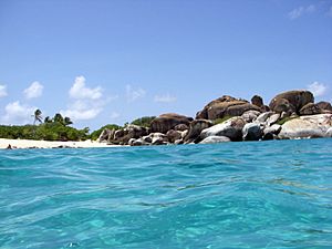
One of the most famous places on Virgin Gorda is called "the Baths". It's a very popular spot for tourists. At the Baths, you'll see huge granite boulders piled up on the beach. These rocks form cool caves and grottoes that are open to the sea. Even though the island was formed by volcanoes, these granite rocks are different. They formed deep underground and became exposed after many years of erosion.
North of the Baths, you'll find the Virgin Gorda Yacht Harbor. It's a great place for boats. Another interesting spot is the old Copper Mine. It's a historical ruin that you can explore.
North Sound: A Watersports Paradise
At the northeast end of the island is North Sound, also known as Gorda Sound. It's one of the world's best harbors! Four islands and many reefs surround it. This keeps the water calm and perfect for watersports. There are over 3,000 acres (1,200 ha) of protected water to enjoy.
At the eastern end of North Sound is a great place to anchor boats, near Biras Hill. The Bitter End Yacht Club is located here. It's a village, resort, and marina that stretches for about a mile along the coast.
Virgin Gorda's History
The famous explorer Christopher Columbus is said to have named the island "the Fat Virgin." He thought the island's shape on the horizon looked like a woman lying on her side.
North Sound has an important history. In 1595, two famous British admirals, Sir Francis Drake and Sir John Hawkins, met their fleet there. They were important figures who helped Britain become a strong naval power.
Twenty-six ships anchored in the sound. The admirals used the large hill at Bitter End to practice for an attack on San Juan. They wanted to take Puerto Rico from Spain. Both admirals died on this trip. This means Bitter End might be the last place these legendary sailors stood on British soil.
Getting Around Virgin Gorda
You can reach Virgin Gorda by ferry from nearby islands like Tortola, St. Thomas, and St. John. Small airlines also fly to the island.
Virgin Gorda Airport
The Virgin Gorda Airport is important for travel. In 2010, the airport had to meet new international safety rules. It was temporarily restricted to only a few airlines. But the airport reopened in December 2010 after improvements were made.
Many tourists visit Virgin Gorda by boat from other islands. They often fly into Tortola or St. Thomas and then take a boat to Virgin Gorda.
Learning on Virgin Gorda
The British Virgin Islands government runs several schools. Children on Virgin Gorda attend Robinson O'Neal Memorial Primary School. There's also the Bregado Flax Educational Centre. This school opened in 1982 and teaches both primary and secondary students.
See also
 In Spanish: Virgen Gorda para niños
 | Claudette Colvin |
 | Myrlie Evers-Williams |
 | Alberta Odell Jones |


