Heuvelland facts for kids
Quick facts for kids
Heuvelland
|
|||
|---|---|---|---|
 |
|||
|
|||
| Country | Belgium | ||
| Community | Flemish Community | ||
| Region | Flemish Region | ||
| Province | West Flanders | ||
| Arrondissement | Ypres | ||
| Area | |||
| • Total | 94.24 km2 (36.39 sq mi) | ||
| Population
(2018-01-01)Lua error in Module:Wd at line 1575: attempt to index field 'wikibase' (a nil value).
|
|||
| • Total | Lua error in Module:Wd at line 1,575: attempt to index field 'wikibase' (a nil value). | ||
| Postal codes |
8950-8954, 8956, 8958
|
||
| Area codes | 057 | ||
| Website | www.heuvelland.be | ||
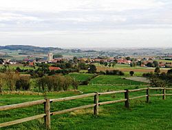
Heuvelland is a town (also called a municipality) in Belgium. It's located in the West Flanders province. The name Heuvelland means "hill country" in Dutch. This is because the area has many hills.
Heuvelland is made up of eight small villages: Dranouter, Kemmel, De Klijte, Loker, Nieuwkerke, Westouter, Wijtschate, and Wulvergem. It's a quiet, countryside area with not many people. It is found between the towns of Ypres and Poperinge. In 2006, about 8,217 people lived in Heuvelland. The area is about 94 square kilometers.
Contents
Geography
The Landscape of Heuvelland
Heuvelland is part of an area known as the West-Flemish Hills. These hills make the landscape unique and beautiful.
The highest hill in Heuvelland is the Kemmelberg, which is 154 meters tall. Other important hills include the Vidaigneberg (136 m), the Rodeberg (129 m), and the Scherpenberg (125 m). There is also a smaller hill in Wijtschate (82 m). The Zwarteberg is located on the border with France.
Villages in Heuvelland
Heuvelland is made up of eight small villages. Before 1977, most of these villages were separate towns. These include Dranouter, Kemmel, Loker, Nieuwkerke, Westouter, Wijtschate, and Wulvergem. De Klijte was not independent; it was part of Reningelst.
Kemmel, Wijtschate, Nieuwkerke, and Westouter are the biggest villages. Each has more than 1,000 people. The main town hall and police station are in Kemmel. Wijtschate has the main library and sports hall. Nieuwkerke has the recycling center. The other four villages are smaller and have fewer services.
There are also small groups of houses on top of the Rodeberg and Zwarteberg hills. Here you can find small shops, places for tourists, and restaurants. Part of the town of Mesen also extends into Wijtschate.
| # | Name | Area (km2) | Population (2001) |
|---|---|---|---|
| I | Kemmel | 12,99 | 1.170 |
| II | Wijtschate | 26,24 | 2.109 |
| III | Wulvergem | 3,50 | 264 |
| IV | Nieuwkerke | 17,49 | 1.513 |
| V | Dranouter | 10,73 | 703 |
| VI | Loker | 6,80 | 572 |
| VII | Westouter | 11,64 | 1.422 |
| VIII | De Klijte | 4,93 | 576 |
Nearby Towns and Villages
Heuvelland shares borders with many other towns and villages. These include:
- Poperinge
- Reningelst
- Dikkebus
- Vlamertinge
- Voormezele
- Hollebeke
- Houthem
- Bas-Warneton
- Warneton
- Mesen
- Ploegsteert
- Nieppe (in France)
- Bailleul (in France)
- Saint-Jans-Cappel (in France)
- Boeschepe (in France)
History
Heuvelland During World War I
Heuvelland was a very important place during World War I. It was part of the Ypres Salient, where many big battles happened. The front line, where soldiers fought, often ran through the area of Wijtschate. Both sides captured and lost this area many times.
Spanbroekmolen was a strong German base. In 1916, German soldiers used gas attacks against British troops in Wulvergem. The Kemmelberg hill was also very important during the Battle of the Lys. German soldiers built trenches (called Bayernwald) in Croonaert Wood. From these trenches, they could see Ypres. Today, you can visit the Bayernwald trenches as an open-air museum.
Many war cemeteries are in Heuvelland. These include Godezonne Farm, RE Farm, Spanbroekmolen, Suffolk, Klein Vierstraat, and Kemmel Number 1 French Cemetery. These cemeteries are a reminder of the many soldiers who lost their lives there.
Notable People
- Petrus Plancius, a famous mapmaker and astronomer, was born in Dranouter in 1552.
- Geike Arnaert, a singer from the band Hooverphonic, was born and grew up in Westouter.
Images for kids
See also
 In Spanish: Heuvelland (Bélgica) para niños
 | Misty Copeland |
 | Raven Wilkinson |
 | Debra Austin |
 | Aesha Ash |


