Hillabee facts for kids

Hillabee was a very important town for the Muscogee (Creek) people. It was located in east central Alabama. The Muscogee people lived there before they were forced to move in the 1830s. This event is known as the Indian Removals.
Hillabee was more than just one town. It was a group of towns and villages. This group was called the Hillabee complex. The people who lived there were sometimes called the Hillabees. This name just meant they were Muscogee people from that area. It was not a separate tribe.
The name "Hillabee" comes from the Muscogee language. The word is helvpe (pronounced /hílapi/). It means "quick" or "swift." This might have been because of the fast-flowing streams nearby.
Contents
Where Was Hillabee Located?
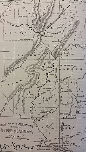
Hillabee and its smaller villages were found along two creeks. These were Little Hillabee Creek and Enitachopco Creek. They joined together to form Big Hillabee Creek. Some villages in this area were Echoseis Ligau, Enitachopko, Lanudshi Apala, and Oktasassi. Other nearby towns linked to Hillabee included Oakfuskee, Little Oakfuskee, and Atchinalgi.
Today, this area is in southern Clay County. It is also in northern Tallapoosa County. This is north of Alexander City. Modern villages like Millerville and Bluff Springs are now in the old Hillabee complex area.
Hillabee's History
The Hillabee complex has a long history. It existed along the Hillabee and Enitachopco Creeks since at least the late 1600s. In the late 1700s and early 1800s, it was in the middle of the Creek Confederacy's land. The number of people living there likely grew after the Creek War (1813–1814). However, it later decreased. Muscogee settlement in the area ended when the people were forced to move in the 1830s.
Hillabee During the Creek War
The Creek War was part of the War of 1812. During this time, the Muscogee (Creek) people were divided. Some fought against the United States. They were known as the Red Sticks. The Hillabee people had been allies of the Red Sticks. This was true until the Battle of Tallushatchee and Battle of Talladega.
Many Hillabee Creeks fought against General Andrew Jackson's forces at Talladega. They lost badly in this battle. After the defeat, they asked for peace. General Jackson agreed to peace on November 17, 1813. However, one day later, something terrible happened. Hillabee villages were attacked by troops led by General William Cocke. He did not know about the peace agreement.
The villages of Little Oakfusky and Genalga were completely destroyed. Then, the main town of Hillabee was attacked. The Creeks thought they were at peace. They were completely surprised and could not defend themselves much. During this attack, 64 Creek people were killed. Another 29 were wounded. Also, 237 people were captured. They were sent to Fort Armstrong.
The Hillabees felt betrayed by this attack. They then rejoined the Red Stick alliance. They remained strong enemies of the Americans for the rest of the war.
Important Trading Paths
The Hillabee complex was near several important trading paths. These included the Oakfuskee Trail (also called the Upper Creek Trading Path). There was also the Weogulfga-Oakfuskee Trail and the Cussetta Trading Path. After the 1814 Treaty of Fort Jackson, new roads were built. The United States and white settlers improved roads across Creek lands.
Roads that went through the Hillabee area included the McIntosh Road. This road was also called the Georgia Road. It connected Coweta to Talladega. The Federal Road also passed through. It connected Milledgeville to Mobile. This road was originally an Indian trail called the Three-Notch Road. Part of the Weogulfga-Oakfuskee Trail near Hillabee was made wider. It became known as the Chapman Road.
 | Jackie Robinson |
 | Jack Johnson |
 | Althea Gibson |
 | Arthur Ashe |
 | Muhammad Ali |

