Hillandale, Maryland facts for kids
Quick facts for kids
Hillandale, Maryland
|
|
|---|---|

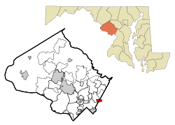
Location of Hillandale, Maryland
|
|
| Country | |
| State | |
| Counties | |
| Area | |
| • Total | 1.89 sq mi (4.89 km2) |
| • Land | 1.89 sq mi (4.89 km2) |
| • Water | 0.00 sq mi (0.00 km2) |
| Elevation | 246 ft (75 m) |
| Population
(2020)
|
|
| • Total | 5,774 |
| • Density | 3,056.64/sq mi (1,180.17/km2) |
| Time zone | UTC-5 (Eastern (EST)) |
| • Summer (DST) | UTC-4 (EDT) |
| ZIP code |
20903
|
| Area code(s) | 301, 240 |
| FIPS code | 24-38850 |
| GNIS feature ID | 2389929 |
Hillandale is a community in Maryland, United States. It's not an official city or town. Instead, it's called an "unincorporated area" and a "census-designated place." This means it's a place with a name and borders, used for counting people by the government.
Hillandale is special because it's located across two different counties: Montgomery County and Prince George's County. In 2020, about 5,774 people lived there.
This area is found between the county line to the east and the Anacostia River to the west. To the north is McCeney Avenue, and to the south is the Capital Beltway. Hillandale is close to other communities like Adelphi, Avenel, White Oak, and Beltsville.
Contents
Exploring Hillandale's Location
Hillandale is part of a larger postal area known as Silver Spring. This means that even though it has its own name, its mail might say Silver Spring.
The United States Census Bureau says that Hillandale covers about 5.3 square kilometers (or 1.89 square miles) of land. There is no water area within its borders.
Neighboring Communities
In Montgomery County, Hillandale is next to the Silver Spring area. The Capital Beltway separates them. To the west, across the Northwest Branch Anacostia River, is the Four Corners area. To the north, you'll find the White Oak community.
In Prince George's County, Hillandale borders the Beltsville area, with the Paint Branch stream in between. To the south, across the Capital Beltway, is the Adelphi community.
Who Lives in Hillandale?
The number of people living in Hillandale changes over time. In 2010, the population was 6,043. By 2020, it had slightly decreased to 5,774 people.
A Look at the Community in 2020
Hillandale is a diverse place, meaning people from many different backgrounds live there. The 2020 census showed that about 25% of the people were White (not Hispanic). Around 24% were Black or African American (not Hispanic). About 11% were Asian (not Hispanic).
A large group, about 35% of the population, identified as Hispanic or Latino. People of Hispanic or Latino background can be of any race. This mix of cultures makes Hillandale a vibrant community.
Learning in Hillandale
Students living in Hillandale go to different schools depending on which county they live in.
If you live in the Montgomery County part of Hillandale, you would attend schools run by Montgomery County Public Schools (MCPS).
If you live in the Prince George's County part, you would go to schools managed by Prince George's County Public Schools. For example, students there might go to Cherokee Lane Elementary School, Buck Lodge Middle School, and High Point High School.
See also

- In Spanish: Hillandale (Maryland) para niños

