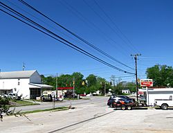
Hillsboro, Tennessee facts for kids
Quick facts for kids
Hillsboro, Tennessee
|
|
|---|---|
 |
|
| Country | United States |
| State | Tennessee |
| County | Coffee |
| Area | |
| • Total | 4.12 sq mi (10.67 km2) |
| • Land | 4.12 sq mi (10.67 km2) |
| • Water | 0.00 sq mi (0.01 km2) |
| Elevation | 1,053 ft (321 m) |
| Population
(2020)
|
|
| • Total | 433 |
| • Density | 105.15/sq mi (40.60/km2) |
| Time zone | UTC-6 (Central (CST)) |
| • Summer (DST) | UTC-5 (CDT) |
| ZIP code |
37342
|
| Area code(s) | 931 |
| GNIS feature ID | 2586062 |
Hillsboro is a small community in Coffee County, Tennessee, in the United States. It is known as an "unincorporated community." This means it does not have its own local government like a city or town.
For counting purposes, Hillsboro is also a census-designated place. This is a special area the government uses to collect information about people living there. In 2020, about 433 people lived in Hillsboro.
The community is located where two main roads meet: U.S. Route 41 and Tennessee State Route 127. It sits between the towns of Manchester to the northwest and Monteagle to the southeast. To the east, you can see the Cumberland Plateau, which is a large, flat-topped mountain area. To the west is Arnold Air Force Base.
People in Hillsboro
This section tells us about the people who live in Hillsboro. It uses information gathered during the United States Census, which counts everyone in the country every ten years.
Population Changes Over Time
The number of people living in Hillsboro has changed a little over the years. Here's how the population has been recorded:
| Historical population | |||
|---|---|---|---|
| Census | Pop. | %± | |
| 2020 | 433 | — | |
| U.S. Decennial Census | |||
See also
 In Spanish: Hillsboro (Tennessee) para niños
 | Dorothy Vaughan |
 | Charles Henry Turner |
 | Hildrus Poindexter |
 | Henry Cecil McBay |


