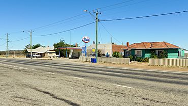
Hines Hill, Western Australia facts for kids
Quick facts for kids Hines HillWestern Australia |
|
|---|---|

Great Eastern Highway, Hines Hill, 2014
|
|
| Established | 1910 |
| Postcode(s) | 6413 |
| Elevation | 255 m (837 ft) |
| Area | [convert: needs a number] |
| Location |
|
| LGA(s) | Shire of Merredin |
| State electorate(s) | Central Wheatbelt |
| Federal Division(s) | Durack |
Hines Hill is a small town in Western Australia. It is located about 240 kilometers (that's about 150 miles) east of Perth. You can find it between the towns of Merredin and Doodlakine.
The town sits right on the Great Eastern Highway, which is a major road. It's also near the edge of Lake Baandee. Hines Hill is home to one of the first privately owned weighbridges in Western Australia. A weighbridge is a large scale used to weigh big vehicles like trucks, often to check how much grain they are carrying.
Exploring Hines Hill
Location and History
Hines Hill is a stop for important train services like the MerredinLink and Prospector. These trains help people travel across the region. The railway line was built through this area in 1894 and opened for trains in 1895.
The town itself was officially named in 1910. It got its name from a nearby hill, which is also called Hines Hill. People believe this hill was named after a man named Jack Hines. He was a sandalwood collector who worked in the area a long time ago.
What the Town Produces
The land around Hines Hill is very important for farming. Farmers in this area grow a lot of wheat and other cereal crops. These crops are used to make food like bread and pasta.
Hines Hill is also a "receival site" for Cooperative Bulk Handling. This means it's a place where farmers bring their harvested crops, like wheat, to be stored and then sent to other places. It's a key part of the farming process in Western Australia.
Train Connections
The AvonLink and Prospector train services, run by Transwa, stop at Hines Hill. There is at least one train service each day.
| Preceding station | Following station | |||
|---|---|---|---|---|
| Doodlakine
towards East Perth
|
MerredinLink | Merredin
Terminus
|
||
| Prospector | Merredin
towards Kalgoorlie
|
|||
 | Georgia Louise Harris Brown |
 | Julian Abele |
 | Norma Merrick Sklarek |
 | William Sidney Pittman |


