
Hollinwood Branch Canal facts for kids
Quick facts for kids Hollinwood Branch Canal |
|
|---|---|

Aqueduct over the River Medlock and remains of the first lock
|
|
| Specifications | |
| Maximum boat length | 70 ft 0 in (21.34 m) |
| Maximum boat beam | 7 ft 0 in (2.13 m) |
| Locks | 8 |
| Status | Restoration proposed |
| History | |
| Original owner | Ashton Canal Company |
| Date of act | 1792 |
| Date closed | 1897 |
| Geography | |
| Start point | Hollinwood |
| End point | Droylsden |
| Branch(es) | Fairbottom Branch |
| Branch of | Ashton Canal |
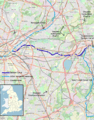
The Hollinwood Branch Canal was a waterway near Hollinwood, in Oldham, England. It connected to the main Ashton Canal at Fairfield Junction. The canal was a bit over 4.5 miles (7.2 km) long. It passed through Droylsden and Waterhouses before ending at Hollinwood Basin. Along its path, it had eight locks, which are like water elevators for boats. Four locks were at Waterhouses (locks 19–22) and four more at Hollinwood (locks 23–26).
Just above lock 22 at Waterhouses, the Fairbottom Branch Canal began. Beyond Hollinwood Basin, there was a private branch called the Werneth Branch Canal. This branch had no locks and led to Old Lane Colliery, opening in 1797. Today, parts of the canal are a special place for nature, known as a biological Site of Special Scientific Interest and a Local Nature Reserve.
Contents
History of the Hollinwood Canal
The Hollinwood Branch Canal was mostly surrounded by countryside, except for some mills and factories in Droylsden. Its main job was to carry coal from many local mines to the factories and mills near the Ashton Canal. People also traveled along the canal by boat.
The canal was used a lot until about 1928. After that, its use quickly dropped because trains and roads became popular. Another big problem was that the ground was sinking due to mining. This sinking made the canal difficult to use. It unofficially closed in 1932, though some parts could still be used. Most of the canal officially closed in 1955. The small part remaining from Fairfield Junction officially closed in 1961.
Future Plans for the Canal
Most of the old canal route is still there. Now, there are plans to open it again for fun activities like boating. Local councils support these plans. However, fixing this canal is harder than fixing the Stockport Branch Canal.
The ground has sunk because of mining. Also, the Manchester ring road has cut across the canal's path twice. This means new aqueducts (bridges that carry water) would need to be built. Another aqueduct would also be needed to replace one that was taken down over a railway. The part of the canal leading up to Hollinwood Basin cannot be restored because buildings are now in the way. However, there are plans to connect the rest of the canal to the Rochdale Canal. This would happen with a short new canal from near lock 23. This link was actually planned way back in 1792 but was never built.
The first part of the restoration has already begun. A £100 million project in Droylsden includes new homes, shops, and restaurants. This project is built around a new marina, which connects to the canal. The marina opened in September 2008. About 190 yards (170 m) of the canal from the Ashton Canal junction have been fixed up. New places for boaters are now available near lock 18. Original plans would have stopped further restoration, but they were changed. Now, the canal will pass under a new building.
Cool Features of the Canal

The Hollinwood Branch Canal at Waterhouses is special among canals in Britain. It is now part of the Daisy Nook Country Park, owned by the National Trust. In about 1,320 yards (1,210 m), it had almost every type of canal feature, plus some unusual ones. Here are some of the features that were once found there, starting and ending with road bridges:
- A road bridge called Waterhouses Bridge.
- A tunnel (Waterhouses, Boodle or Dark Tunnel). This tunnel was opened up in the 1920s.
- A stone aqueduct with one arch over the River Medlock (Waterhouses Aqueduct).
- A set of four locks (19–22). The middle two were "staircase locks." This means the top gates of one lock were also the bottom gates of the next lock, making them very close together.
- A small brick hut near lock 21, likely used to pay workers.
- A canal junction where the Fairbottom Branch Canal began (Waterhouses Junction).
- The path for horses (towpath) from the Fairbottom Branch Canal crossed the Hollinwood Branch Canal on a swivel bridge. This bridge was located at the top of lock 22.
- A weir (a small dam) where extra water flowed over. The towpath crossed this weir on a low stone pier.
- A lock-keeper’s cottage, which also served as an office for collecting tolls.
- A pumping engine (a type of machine) that pumped water from below lock 19 back up to the canal above lock 22.
- A wooden channel (flume) that carried water from the pump house back to the canal.
- A footbridge over the canal with a fancy iron railing (Occupation Bridge).
- A cast-iron aqueduct over Crime Lane (Crime Aqueduct).
- A lake next to the canal called Crime Lake. This lake formed when the canal was built and blocked a stream. The stream's water then collected, forming the lake. It was officially called Crime Bank Reservoir.
- A road bridge called Crime Bridge.
We should also mention a neighbor of the pumping engine, known as ‘Fairbottom Bobs’. This was a Newcomen steam engine. It was used to pump water out of a coal mine. The water was pumped along a wooden channel for about 219 yards (200 m). Then, it flowed into the Fairbottom Branch Canal at Fenny Fields Bridge.
In 1929, this engine was taken apart and moved to the United States by Henry Ford. He had it completely fixed up. Now, it is at the Henry Ford Museum and Greenfield Village in Dearborn, Michigan.
What's in a Name?
The name "Fairbottom Bobs" is actually older than the Newcomen engine. It was first used to describe pumps that were powered by water wheels from the River Medlock. The 'bobs' were L-shaped parts that changed the circular motion of the wheels into an up-and-down pumping action. Older maps show the Newcomen engine as "Mr. Lees' Engine." When the canal was built, the Ashton Company had to talk with Mr. Lees (in 1798) to get the water redirected into the canal.
Places of Interest
| Point | Coordinates (Links to map resources) |
OS Grid Ref | Notes |
|---|---|---|---|
| Old Lane Colliery basin | 53°31′52″N 2°08′29″W / 53.5310°N 2.1414°W | SD907038 | |
| Hollinwood Basin | 53°31′16″N 2°08′36″W / 53.5211°N 2.1433°W | SD905027 | Original end point |
| Crime Lake | 53°30′28″N 2°07′40″W / 53.5079°N 2.1277°W | SD916012 | |
| Fairbottom Junction | 53°30′22″N 2°07′21″W / 53.5060°N 2.1225°W | SD919010 | |
| Fenny Fields Bridge wharf | 53°30′43″N 2°05′58″W / 53.5120°N 2.0995°W | SD935017 | End of Fairbottom branch |
| M60 motorway embankment | 53°29′56″N 2°07′33″W / 53.4989°N 2.1258°W | SD917002 | Route cut by motorway |
| Site of railway aqueduct | 53°29′23″N 2°08′12″W / 53.4897°N 2.1367°W | SJ910992 | |
| Junction with Ashton Canal | 53°28′40″N 2°08′58″W / 53.4779°N 2.1495°W | SJ901979 |
Images for kids
-
Map of Ashton Canal and its branches

