
Hoop hole facts for kids
Quick facts for kids Hoop Hole |
|
|---|---|

Hoop Hole
Location in Virginia
|
|
| Location | Botetourt County Virginia, United States |
| Area | 5,625 acres (22.76 km2) |
| Administrator | U.S. Forest Service |
Hoop Hole is a beautiful wild area located in the George Washington and Jefferson National Forests in western Virginia. It's a special place that the Wilderness Society wants to protect. They call it a "Mountain Treasure" because it's so important to keep it safe from logging and new roads.
This area is popular with people who enjoy hunting and fishing. It also has a National Recreation Trail. This trail offers amazing views of streams and waterfalls. Hoop Hole is part of a larger natural area called the Barbours Creek-Shawvers Run Cluster.
Contents
Exploring Hoop Hole: Location and Trails
Hoop Hole is found in the Appalachian Mountains of Southwestern Virginia. It's about 8 miles southeast of Covington, Virginia. The area is bordered by two roads: Virginia Route 615 on the southeast and Virginia Route 621 on the northeast.
You can explore Hoop Hole using several trails:
- Hoop Hole National Recreation Trail: This trail is 9.0 miles long and is considered difficult. It's marked with blue blazes and is great for hiking, horseback riding, and mountain biking.
- Iron Ore Trail: This trail is 2.4 miles long and is a moderate difficulty. It's marked with yellow blazes and is also good for hiking, horseback riding, and mountain biking.
A small part of The Potts Jeep Road (1.1 miles) is on the western edge of the area. Virginia Route 615, on the southeast, is a special scenic road called a Virginia Byway. The Roaring Run Trail and Roaring Run Recreation Area are located at the northeastern corner of Hoop Hole.

The map next to this text shows the boundaries of the Hoop Hole wildland. The Wilderness Society created this map. It shows that about one-third of the area is in the James River Ranger District. This district is part of the George Washington National Forest. The other two-thirds are in the New Castle Ranger District, which is part of the Jefferson National Forest.
You can find more information about roads and trails on National Geographic Maps 788 (Covington, Alleghany Highlands). You can also get lots of information like topographic maps and satellite views by clicking the coordinates link at the top right of this page.
Besides the main trails, you can also explore old logging roads. These roads were used a long time ago when trees were cut down in the early 1900s. Many are now overgrown but can still be walked. You can find these old roads and even old railroad paths by looking at historical maps from the United States Geological Survey (USGS). The Hoop Hole area is shown on the USGS topographic map called Strom.
Nature and Wildlife in Hoop Hole
Hoop Hole is part of a larger natural region called the Ridge and Valley Subsection. This area is known for its Central Appalachian Broadleaf Coniferous Forest.
You can find many types of trees here. These include yellow poplar, northern red oak, white oak, and eastern hemlock. On the north and west sides, white oak and hickory trees are common. On the ridgetops and slopes facing south and east, you'll see chestnut oak and yellow pine.
Unique Plants and Animals
Hoop Hole is home to some very rare plants and animals. One unusual plant is the pirate bush, which is globally rare. There's also a special invertebrate called the orangefin madtom. You might also spot larger animals like bears, deer, and grouse.
Table Mountain Pine and Fire
Some parts of Hoop Hole have forests of pure table mountain pine trees. These trees usually grow on dry, sunny ridges and slopes. Table mountain pine trees need fire to grow new trees. This is because their cones are "serotinous," meaning they need heat from a fire to open up and release their seeds. To keep these forests healthy, controlled fires are sometimes set on purpose. This helps the trees reproduce and keeps the forest in good condition.
Some trees in the George Washington National Forest part of Hoop Hole are very old. They are 140 years old or even older. Rules are in place to protect animals from illegal hunting in the area.
Hoop Hole's Landscape
The Hoop Hole area is known for its long ridges that run from northeast to southwest. These ridges are made of sandstone or shale. Between the ridges are valleys with streams flowing into them. Rich Patch, Pine, and Deisher Mountains are examples of these ridges.
The highest point in Hoop Hole is 3728 feet high, along the top of Rich Patch Mountain. The lowest point is about 3000 feet, at Crawford Branch on the east side. Most of the area (about 75 percent) has sandstone underneath the ground. The rest of the area has shale, from formations like the Brallier and Martinsburg.
The area is also where several streams begin, including Hipes Branch, Stony Run, Wolf Branch, Crawford Branch, and Deisher Branch.
Roaring Run Recreation Area
The Roaring Run Recreation Area is located at the northeastern edge of the Hoop Hole wild area. It's a starting point for the Iron Ore trail. It also has several trails that follow Roaring Run, offering views of the beautiful Roaring Run Falls.
The Roaring Run Wildflower Trail leads to a scenic waterfall where the water drops 35 feet over rocks. The moist environment and sunlight along this trail create a perfect home for many different wildflowers. It has the most diverse collection of wildflowers in the New Castle Ranger District. You can find flowers like showy orchis, crested dwarf iris, and bloodroot here. In spring and summer, you might also see woodland birds like the wood thrush and ovenbird.

Across the creek from the picnic area, you can see the remains of the Roaring Run Furnace. In the early 1800s, this furnace was used to melt iron ore from the mountains. They would heat sandstone and quartzite containing iron ore to very high temperatures (2600 degrees). The melted iron would then flow into sand trenches and cool into solid blocks. These blocks were used to make iron products like stoves and skillets. You can still find colorful, marble-sized stones around the furnace grounds. These stones are a leftover product from the heating process, similar to volcanic glass called obsidian.
Protecting Hoop Hole: Forest Service Management
The U.S. Forest Service looks after Hoop Hole. They have studied their lands to see which areas could be protected as "wilderness." Wilderness areas have a very high level of protection from new buildings or development. Areas that are good for this protection are called "inventoried roadless areas."
Later, a "Roadless Rule" was created. This rule limits building new roads in these special areas. It helps protect the environment by reducing the negative effects of road construction. Hoop Hole was included in this review, which means it is protected from new roads and large-scale timber cutting.
The Hoop Hole Trail was used to help stop the 50-acre Roaring Run fire in 2010. Since then, the trail has been repaired and is open again. The Forest Service also classifies areas like Hoop Hole as "Special Areas." This means they have unique plans to manage them, ensuring visitors can enjoy the forest in different ways.
Images for kids
-
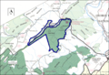
Boundary of the Hoop Hole wildland as identified by the Wilderness Society
-

Roaring Run Furnace
