Hope, New Mexico facts for kids
Quick facts for kids
Hope, New Mexico
|
|
|---|---|
|
Village
|
|

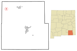
Location of Hope, New Mexico
|
|
| Country | United States |
| State | New Mexico |
| County | Eddy |
| Area | |
| • Total | 1.22 sq mi (3.17 km2) |
| • Land | 1.22 sq mi (3.17 km2) |
| • Water | 0.00 sq mi (0.00 km2) |
| Elevation | 4,095 ft (1,248 m) |
| Population
(2020)
|
|
| • Total | 113 |
| • Density | 92.40/sq mi (35.66/km2) |
| Time zone | UTC-7 (Mountain (MST)) |
| • Summer (DST) | UTC-6 (MDT) |
| ZIP code |
88250
|
| Area code(s) | 575 |
| FIPS code | 35-33290 |
| GNIS feature ID | 2413559 |
Hope is a small village in Eddy County, New Mexico, United States. It's about 20 miles (32 km) west of Artesia along U.S. Route 82. Hope has had its own post office since 1890. In 2020, the village had a population of 113 people.
Contents
Where is Hope Located?
Hope is found in the northwestern part of Eddy County. It's located at coordinates 32.811916°N and 104.733565°W. U.S. Route 82 goes right through the middle of the village. This road leads east to Artesia and west, over the Sacramento Mountains, to Alamogordo.
The United States Census Bureau says that the village covers a total area of about 1.22 square miles (3.17 square kilometers). All of this area is land.
What's the Weather Like?
Hope, New Mexico, has a climate with warm summers and mild winters. The highest temperature ever recorded was 115°F (46°C) in June. The lowest was -10°F (-23°C) in December.
The average high temperature in July is about 93°F (34°C). In January, the average high is around 56°F (13°C). Hope gets about 12.86 inches (32.7 cm) of rain each year. Most of the rain falls in the summer months, especially July, August, and September. Snowfall is usually very light, with an average of only 3.4 inches (8.6 cm) per year.
A Look at Hope's History
Hope was first started in 1884 and was called "Badgerville." The name was changed to Hope in 1890 when the post office was established.
The village gained some fame in 1950. Life magazine wrote an article about Hope on May 29, 1950. It talked about the village's new "Petticoat City Government," which meant that many of the leaders were women. Ethel Altman was the mayor at that time.
Who Lives in Hope?
| Historical population | |||
|---|---|---|---|
| Census | Pop. | %± | |
| 1910 | 417 | — | |
| 1920 | 430 | 3.1% | |
| 1930 | 275 | −36.0% | |
| 1940 | 289 | 5.1% | |
| 1950 | 186 | −35.6% | |
| 1960 | 108 | −41.9% | |
| 1970 | 90 | −16.7% | |
| 1980 | 111 | 23.3% | |
| 1990 | 101 | −9.0% | |
| 2000 | 107 | 5.9% | |
| 2010 | 105 | −1.9% | |
| 2020 | 113 | 7.6% | |
| U.S. Decennial Census | |||
In 2000, there were 107 people living in Hope. These people lived in 45 different homes, and 27 of these were families. The population density was about 92 people per square mile (35 people per square kilometer).
Most of the people in Hope were White (about 77.57%). About 16.82% of the population identified as Hispanic or Latino.
About 26.7% of the homes had children under 18 living there. Many homes (48.9%) were married couples. The average household had 2.38 people.
The people in Hope were of different ages. About 25.2% were under 18 years old, and 27.1% were 65 years or older. The average age in the village was 42 years.
Schools in the Area
Hope is part of the Artesia Public Schools district. Younger students (Kindergarten through 8th grade) from Hope attend Peñasco Elementary School, which is located west of the village.
For older students, Artesia Park Junior High School serves all 9th graders in the district. Students in grades 10-12 go to Artesia High School, which is the main high school for the area.
See also
 In Spanish: Hope (Nuevo México) para niños
 | William Lucy |
 | Charles Hayes |
 | Cleveland Robinson |


