Horn Island, Queensland facts for kids
Quick facts for kids HornQueensland |
|||||||||||||||
|---|---|---|---|---|---|---|---|---|---|---|---|---|---|---|---|

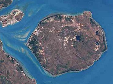
View of Horn Island from above
|
|||||||||||||||
| Population | 533 (2021 census) | ||||||||||||||
| • Density | 2.6308/km2 (6.814/sq mi) | ||||||||||||||
| Elevation | 4 m (13 ft) | ||||||||||||||
| Area | 202.6 km2 (78.2 sq mi) | ||||||||||||||
| Time zone | AEST (UTC+10:00) | ||||||||||||||
| LGA(s) | Shire of Torres | ||||||||||||||
| State electorate(s) | Cook | ||||||||||||||
| Federal Division(s) | Leichhardt | ||||||||||||||
|
|||||||||||||||
|
|||||||||||||||
|
Native name:
Narupai
|
|
|---|---|

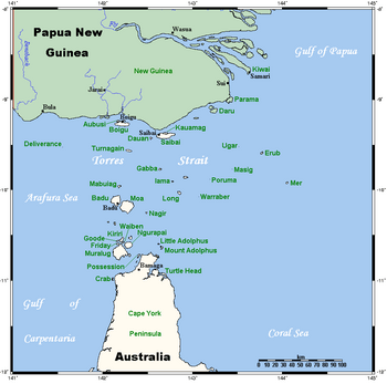
A map of the Torres Strait Islands showing "Ngurapai" just north of Cape York Peninsula
|
|
| Geography | |
| Location | Northern Australia |
| Archipelago | Torres Strait Islands |
| Adjacent bodies of water | Torres Strait |
| Area | 53 km2 (20 sq mi) |
| Administration | |
| State | Queensland |
Horn Island, also known as Ngurupai or Narupai in the local language, is an island in the Torres Strait Islands group. It's located in the Torres Strait, which is in Northern Australia between the Australian mainland and Papua New Guinea. The island is part of the Horn area within the Shire of Torres. The town of Wasaga is found on the north-western coast of the island (10°35′40″S 142°14′53″E / 10.5944°S 142.2480°E). In 2021, 533 people lived on Horn Island.
Contents
Exploring Horn Island's Geography
Horn Island covers an area of about 53 square kilometres. It's a very important place because it has the Horn Island Airport. This airport helps people travel to and from Thursday Island, the Australian mainland, and other smaller islands nearby.
Many different people live on Horn Island today, including islanders from across the Torres Strait and people from other places. Every day, many residents take a ferry across the Ellis Channel to Thursday Island. They go there for work and to attend school. The local government, called the Shire of Torres, provides services for the island community.
Horn Island's Rich History
The Kaurareg people call Horn Island Nœrupai. The English name, Horn Island, was given by Matthew Flinders in 1802.
The Town of Wasaga
The town of Wasaga was officially named on April 1, 1971. It was named after Wasaga Billy, who was the first leader of the Horn Island community.
Kaurareg People and Their Land
After a difficult event in 1871 on Prince of Wales Island, some Kaurareg people moved to Horn Island for a short time. Later, the government moved them to Hammond Island (Kœriri), where they stayed until 1922. These islands, including Horn Island, are the traditional lands of the Kaurareg people. Different parts of the islands are owned by different clans. The language spoken by the Kaurareg people is Kala Lagaw Ya.
Gold, Pearling, and World War II
Gold was mined on Horn Island in the 1890s. In the early 1900s, a town grew because of the pearling industry. However, the town became smaller when many non-islander residents had to leave during World War II.
During World War II, a large airbase called Horn Island Aerodrome was built on the island. Japanese planes attacked this airbase several times. The story of the World War II airbase on Horn Island is told in books by Jack Woodward, who was a wireless operator stationed there. The Horn Island Seaplane Base was also built during the war.
The London Missionary Society was the main church influence until 1915, when the Anglican Church took over.
In 1946, some Kaurareg people moved back to Horn Island from Moa Island. They settled in what is now Wasaga Village on the western side of the island. In the late 1980s, gold mining started again. This led to a quick increase in population and building on Horn Island, as land on nearby Thursday Island was becoming hard to find.
The Horn Island State School opened on February 1, 1993. It became part of Tagai State College in 2007.
Horn Island's Population
Here's how the population of Horn Island has changed over the years:
- In 2006, there were 585 people.
- In 2011, there were 539 people.
- In 2016, there were 531 people.
- In 2021, there were 533 people.
Horn Island's Climate
Horn Island has a very warm tropical savanna climate. This means it has hot temperatures all year round.
Wet and Dry Seasons
The wet season lasts from December to April. During this time, it's very humid, and there are often heavy rain showers. Sometimes, tropical cyclones can affect Horn Island, but they are usually not a big threat because the island is close to the Equator.
The dry season runs from May to November. This season has less humidity and very little rain. Horn Island has never recorded a temperature below 15°C (59°F) or a maximum temperature below 25°C (77°F).
| Month | Jan | Feb | Mar | Apr | May | Jun | Jul | Aug | Sep | Oct | Nov | Dec | Year |
|---|---|---|---|---|---|---|---|---|---|---|---|---|---|
| Record high °C (°F) | 36.7 (98.1) |
35.4 (95.7) |
34.8 (94.6) |
33.9 (93.0) |
32.0 (89.6) |
32.4 (90.3) |
30.9 (87.6) |
31.7 (89.1) |
35.8 (96.4) |
35.2 (95.4) |
35.0 (95.0) |
37.9 (100.2) |
37.9 (100.2) |
| Mean daily maximum °C (°F) | 30.9 (87.6) |
30.5 (86.9) |
30.4 (86.7) |
30.4 (86.7) |
29.9 (85.8) |
29.3 (84.7) |
28.8 (83.8) |
29.0 (84.2) |
30.1 (86.2) |
31.0 (87.8) |
31.9 (89.4) |
31.8 (89.2) |
30.3 (86.5) |
| Mean daily minimum °C (°F) | 25.1 (77.2) |
25.0 (77.0) |
25.0 (77.0) |
25.2 (77.4) |
24.7 (76.5) |
23.9 (75.0) |
23.1 (73.6) |
22.9 (73.2) |
23.8 (74.8) |
24.8 (76.6) |
25.7 (78.3) |
25.7 (78.3) |
24.6 (76.3) |
| Record low °C (°F) | 22.4 (72.3) |
21.1 (70.0) |
22.2 (72.0) |
21.1 (70.0) |
17.7 (63.9) |
18.3 (64.9) |
16.0 (60.8) |
15.3 (59.5) |
16.1 (61.0) |
18.4 (65.1) |
19.9 (67.8) |
20.3 (68.5) |
15.3 (59.5) |
| Average precipitation mm (inches) | 387.5 (15.26) |
467.0 (18.39) |
358.2 (14.10) |
228.0 (8.98) |
72.5 (2.85) |
14.7 (0.58) |
8.3 (0.33) |
5.5 (0.22) |
6.3 (0.25) |
16.9 (0.67) |
49.1 (1.93) |
191.5 (7.54) |
1,809 (71.22) |
| Average precipitation days (≥ 0.2 mm) | 21.9 | 21.4 | 20.2 | 15.7 | 10.1 | 9.7 | 8.2 | 5.2 | 3.2 | 4.7 | 5.6 | 13.6 | 139.5 |
| Source: Bureau of Meteorology | |||||||||||||
Education on Horn Island
Tagai State College is a school for students from early childhood up to Year 12. It has 17 different campuses across the Torres Strait. On Horn Island, there is a primary school campus (for early childhood to Year 6) located on Nawie Street (10°35′36″S 142°15′04″E / 10.5932°S 142.2512°E).
There isn't a secondary school on Horn Island itself. Older students attend the secondary campus of Tagai State College on the nearby Thursday Island.
Community Amenities
The Holy Family Catholic Church is located on Outie Street. It is part of the Thursday Island Parish within the Roman Catholic Diocese of Cairns.

