Hoya Mala facts for kids
Quick facts for kids
Hoya Mala
Hoyamala
|
|
|---|---|
|
Barrio
|
|

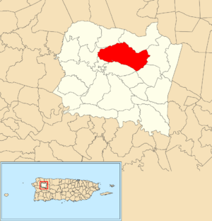
Location of Hoya Mala within the municipality of San Sebastián shown in red
|
|
| Commonwealth | |
| Municipality | |
| Area | |
| • Total | 5.69 sq mi (14.7 km2) |
| • Land | 5.69 sq mi (14.7 km2) |
| • Water | 0 sq mi (0 km2) |
| Elevation | 883 ft (269 m) |
| Population
(2010)
|
|
| • Total | 3,594 |
| • Density | 631.6/sq mi (243.9/km2) |
| Source: 2010 Census | |
| Time zone | UTC−4 (AST) |
Hoya Mala (also called Hoyamala) is a neighborhood, or barrio, located in the town of San Sebastián, Puerto Rico. In 2010, about 3,594 people lived there. It's a part of Puerto Rico, which is a special territory of the United States.
Contents
A Look Back: Hoya Mala's History
Becoming Part of the United States
After the Spanish–American War in 1898, Spain gave Puerto Rico to the United States. This happened because of a special agreement called the Treaty of Paris of 1898. Puerto Rico then became an unincorporated territory of the U.S. This means it's a part of the U.S. but doesn't have all the same rights as a state.
Early Population Counts
In 1899, the U.S. government did a count of all the people in Puerto Rico. This count is called a census. They found that 1,215 people lived in Hoya Mala barrio at that time.
| Historical population | |||
|---|---|---|---|
| Census | Pop. | %± | |
| 1900 | 1,215 | — | |
| 1980 | 2,744 | — | |
| 1990 | 3,084 | 12.4% | |
| 2000 | 3,505 | 13.7% | |
| 2010 | 3,594 | 2.5% | |
| U.S. Decennial Census 1899 (shown as 1900) 1910-1930 1930-1950 1980-2000 2010 |
|||
Exploring Hoya Mala: Sectors and Areas
What are Sectors?
Barrios like Hoya Mala are often divided into smaller areas. These smaller parts are called sectores (which means sectors in English). Think of them like smaller neighborhoods within a larger one. The names of these sectors can be different, such as urbanización or reparto.
Main Sectors in Hoya Mala
Here are some of the sectors you can find in Hoya Mala barrio:
- Carretera 119
- Carretera 447
- Carretera 448
- Sector Capilla Católica
- Sector Daniel Méndez
- Sector Esteban Cardona
- Sector Gabriel Jiménez
- Sector Jiménez
- Sector Julio Lugo
- Sector La 21
- Sector Las Toscas
- Sector Lechuza
- Sector Mercado
- Sector Monroig
- Sector Pascual Ruiz
- Sector Planta de Gas
- Sector Porto Román
- Sector Sharon
Nature's Impact: Río Culebrinas Flooding
In May 2019, Hoya Mala and other areas in nearby towns experienced heavy flooding. This happened when the Río Culebrinas (Culebrinas River) overflowed its banks. The flood caused trees to fall, landslides, and some roads had to be closed.
See also
 In Spanish: Hoya Mala para niños
- List of communities in Puerto Rico
- List of barrios and sectors of San Sebastián, Puerto Rico
 | Audre Lorde |
 | John Berry Meachum |
 | Ferdinand Lee Barnett |


