Hubele Mounds and Village Site facts for kids
Quick facts for kids |
|
|
Hubele Mounds and Village Site
|
|

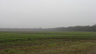
Overview of the site from the west
|
|
| Location | East of the junction of County Roads 950N and 1900E, southeast of Maunie, Illinois |
|---|---|
| Area | 60 acres (24 ha) |
| NRHP reference No. | 78001196 |
| Added to NRHP | August 25, 1978 |
The Hubele Mounds and Village Site is an ancient place in southeastern Illinois. It is an archaeological site, meaning it holds clues about people who lived there long ago. This special site is located near Maunie in White County. The United States government has recognized its importance for understanding history.
Scientists are not sure exactly when people lived at Hubele. Some think it was around 400 BC, while others believe it was closer to AD 1000. Even with different ideas about the dates, everyone agrees that Hubele is very important for learning about the past in this area.
Contents
Where is the Hubele Site Located?
The Hubele site is found about 400 meters (about 1,300 feet) west of the Wabash River. It sits on land that is only a little bit higher than the riverbank. This area might have once been a sandbar next to the river.
Today, the site is part of large farm fields along the river. A protective wall, called a levee, is on the eastern side to stop floods. A line of trees marks the northern edge of the site. Some parts of the site have been changed over time. For example, a road was built on the southern edge, and a drainage ditch was added. However, most of the site, more than five-sixths of it, is still undisturbed.
What Did the Hubele Site Look Like?
Long ago, the Hubele site had seven small earth mounds. These mounds were lined up from north to south. Sadly, none of these mounds are still complete today.
- Archaeologists dug up two of the mounds to study them.
- The other five mounds have been flattened over time by farming. Even the tallest one is now less than 4 feet high.
East of the mounds, there was a village area. Here, archaeologists have found signs of ancient life. These include holes where wooden posts once stood, pits for trash, and fire pits. Many of these features have been found when farmers plow their fields.
How Was the Site Explored?
The Illinois State Museum led an excavation project at Hubele in 1950. Archaeologists dug two test trenches in the village area. Each trench was about 10 by 20 feet. They also carefully removed two of the mounds. They discovered that these mounds had been disturbed before.
Many different kinds of objects were found at the site:
- In the village area, they found projectile points (like arrowheads), pottery pieces, knives, and flint flakes. They also found animal bones and shells.
- Under one of the mounds, they discovered a special pipe made of pipestone. More pottery pieces and projectile points were also found. These points came from flint quarries in Harrison County, Indiana.
More than two thousand pottery pieces were found in the test trenches. Some of these pieces had no markings on them. Scientists are not sure if these pieces were always plain or if their decorations wore off.
Who Lived at Hubele?
Scientists have different ideas about which ancient people lived at Hubele.
- The first researchers thought the villagers were Hopewellian people. These people lived during the Middle Woodland period, from about 400 BC to AD 400. Most of the pottery found was in the Hopewellian style.
- Hubele is one of only four mound sites in southern Illinois believed to be Hopewellian. The others are the Wilson Mounds and Village Site, the Rutherford Site, and the Twenhafel Site.
However, the exact dates for Hubele are still uncertain. This is because no major work has been done there since radiocarbon dating became a common tool. Radiocarbon dating helps scientists find the age of ancient objects.
Later, in 1963, another archaeological survey suggested that Hubele was connected to the Duffy Complex. If this is true, Hubele would be very important. Only three other sites have been clearly identified as Duffy, and they are all close to the Wabash River's mouth. Hubele would be the farthest north known Duffy site. The Duffy people lived around AD 1000, during a time when the Woodland period was changing into the Mississippian period.
Even if Hubele is not proven to be a Duffy site, it is still very important. Its connection to the nearby Hopewellian Wilson Mounds is clear. This makes Hubele one of the most important villages linked to that mound group.
Protecting the Hubele Site
In August 1978, the Hubele Site was added to the National Register of Historic Places. This means it is a special place that needs to be protected because of its archaeological value. The site covers 60 acres of land. It is one of eleven places in White County listed on the National Register. Other archaeological sites in White County on the list include the Wilson and Bieker-Wilson sites.
Images for kids


