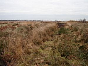
A path through the Humberhead nature reserve.
The Humberhead Levels is a large, flat area of land in northern England. It's located near the western end of the River Humber estuary. This special natural area used to be a huge ancient lake called Glacial Lake Humber. It is surrounded by hills like the Yorkshire Wolds and the Lincolnshire Edge, which is a long, steep slope made of limestone. To the west, it's bordered by another ridge of hills. In the north, the Humberhead Levels blend into the slightly wavier Vale of York, near a pile of rocks and dirt left by a glacier called the Escrick moraine. To the south, it joins the Trent Vale.
Glacial Lake Humber: A Lake from the Ice Age
During the last Ice Age, a giant sheet of ice (a glacier) covered this area. It reached almost to where the city of Doncaster is today. The edge of this glacier was at a place called Escrick. The Escrick moraine, which is a big pile of rocks and dirt, shows how far the glacier reached. This glacier blocked the Humber Gap, which is a valley, and created a huge lake to the north. Over time, the bottom of this lake filled up with thick layers of clay. Some of these clay layers are as deep as 20 meters (about 65 feet!). On top of the clay, you can find layers of peat. Peat is made from dead plants and forms special wet areas called raised mires. At the very bottom of these peat layers, you can even find the remains of an ancient buried forest!
Early Settlers: Life in the Levels
People have lived in the Humberhead Levels for thousands of years. The drier northern parts of the area were settled even before the Roman era. The soil there was lighter, which made it easier to drain using simple hand tools. Because of this, people cleared large parts of the land to raise animals on small farms. The area also had many rivers that were easy to travel on by boat. This was useful for invaders like the Angles in the late 400s and 500s, and the Vikings in the 700s and 800s. They could travel deep into the countryside using these rivers.


