
Huntertown, Indiana facts for kids
Quick facts for kids
Huntertown, Indiana
|
|
|---|---|
 |
|

Location of Huntertown in Allen County, Indiana.
|
|
| Country | United States |
| State | Indiana |
| County | Allen |
| Area | |
| • Total | 5.34 sq mi (13.83 km2) |
| • Land | 5.30 sq mi (13.74 km2) |
| • Water | 0.03 sq mi (0.09 km2) |
| Elevation | 837 ft (255 m) |
| Population
(2020)
|
|
| • Total | 9,141 |
| • Density | 1,723.09/sq mi (665.34/km2) |
| Time zone | UTC-5 (EST) |
| • Summer (DST) | UTC-5 (EST) |
| ZIP code |
46748
|
| Area code(s) | 260 |
| FIPS code | 18-35266 |
| GNIS feature ID | 0436630 |
| Website | www.huntertown.org |
Huntertown is a town located in Allen County, Indiana. It's known for being one of the fastest-growing places in northeastern Indiana. In 2020, about 9,141 people lived there. This was a huge jump of 90 percent in population since 2010!

Contents
Huntertown's History
Huntertown was first settled around 1837. It was founded by William T. Hunter. People originally called the area "The Opening." This was because it was a natural clearing in the forest. The village was located along the Lima Plank Road. This road connected Lima (now Howe) and Fort Wayne.
Early Schools and Growth
In 1856, the Perry Centre Seminary was started in Huntertown. But it closed just five years later. This happened because all the teachers and older students joined the Union Army. The town was officially planned out in 1869. However, it wasn't made an official town until 1966.
Weather Records
Huntertown is special because it has some of the oldest weather records in the United States. A farmer named Rapin Andrews started keeping detailed weather notes in 1839. He continued until he passed away ten years later. His family kept up the observations until 1874. These old weather diaries were given to the U.S. Weather Bureau in 1934. The hottest temperature recorded was 102°F (39°C) in July 1846. The coldest was a chilly -34°F (-37°C) on January 29, 1873.
Recent Developments in Huntertown
Huntertown has grown a lot because many people are moving there. They come from bigger cities like Fort Wayne to live in new neighborhoods. Because of this growth, the town needs more services. For example, the town council grew from three to five members. This helps share the work. The council is also planning a new water plant. They are also working on a new parks board and a large 27-acre (110,000 m²) park.
The town's weekly newspaper, Northwest News, started in 1997. It is located in the old Huntertown State Bank building. This building was once robbed in the 1930s.
Huntertown's Geography
Huntertown is located at 41°13′40″N 85°10′10″W / 41.22778°N 85.16944°W. It sits at an elevation of 837 feet (255 m). The town is along State Road 3/Lima Road, just north of Fort Wayne. Carroll Road forms the southern border between Huntertown and Fort Wayne.
In 2010, Huntertown covered about 3.81 square miles (9.87 km²). Almost all of this area, 3.8 square miles (9.8 km²), is land. Only a tiny part, 0.01 square miles (0.026 km²), is water.
Population of Huntertown
| Historical population | |||
|---|---|---|---|
| Census | Pop. | %± | |
| 1970 | 775 | — | |
| 1980 | 1,265 | 63.2% | |
| 1990 | 1,330 | 5.1% | |
| 2000 | 1,771 | 33.2% | |
| 2010 | 4,810 | 171.6% | |
| 2020 | 9,141 | 90.0% | |
| U.S. Decennial Census | |||
Population in 2010
In 2010, Huntertown had 4,810 people living there. There were 1,726 households. The town had a population density of about 1,266 people per square mile (489/km²). Most of the people (93.6%) were White. There were also smaller groups of African American, Native American, and Asian residents. About 2.3% of the population was Hispanic or Latino.
Many households (45.8%) had children under 18 living with them. The average household had 2.79 people. The average family had 3.21 people. The median age in town was 31.5 years. About 31.9% of residents were under 18.
Population in 2020
As of April 1, 2020, the population of Huntertown grew to 9,141 people.
Images for kids
-
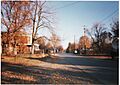
The scenic, historic downtown district of Huntertown on Old Lima Road

See also
 In Spanish: Huntertown (Indiana) para niños
