Icicle Ridge facts for kids
Quick facts for kids Icicle Ridge |
|
|---|---|

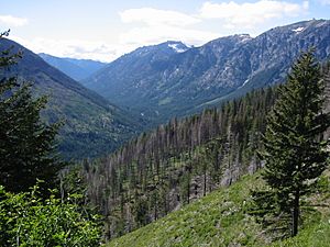
Eastern slope of Icicle Ridge (green hill) at its junction with 4th of July trail viewing towards Big Lou on the right and Grindstone Mountain at the far center
|
|
| Highest point | |
| Peak | Big Lou |
| Elevation | 7,766 ft (2,367 m) |
| Dimensions | |
| Width | 1.1 mi (1.8 km) |
| Geography | |
| Country | United States |
| Parent range | Alpine Lakes Wilderness |
Icicle Ridge is a long mountain ridge in Washington state, United States. It sits on the eastern edge of the Alpine Lakes Wilderness. Many trails lead to Icicle Ridge, which is surrounded by tall mountains, peaks, and beautiful lakes.
The ridge is located just west of the city of Leavenworth. It is part of the land managed by the Okanogan-Wenatchee National Forest.
Icicle Ridge gets its name from the nearby Icicle Creek. The creek's name comes from an old Indian word, na-sik-elt. This word means "narrow canyon." A surveyor named Albert H. Sylvester once said that if you add an "n" to the start of "icicle" and a "t" to the end, you get very close to the original Indian word.
How Glaciers Shaped Icicle Ridge
Icicle Ridge was formed by powerful glaciers long ago. These huge sheets of ice moved slowly, shaping the land. One major ice movement was called the Leavenworth Advance.
This glacier flowed from Icicle Creek. It carved out bowl-shaped hollows, called cirques, along the ridge. Many smaller ice streams also flowed from the main glacier. At its thickest point, the main glacier was about 1,250 feet (380 meters) deep. Other glacier movements, like the Mountain Home and Peshastin advance, also helped shape the area.
Icicle Ridge is made of metamorphic rock called Chiwaukum Schist. You can see many large granite boulders on the ridge. These rocks were picked up and moved by the glaciers. Some boulders also came from landslides or rockfalls.
You can find many piles of rock and dirt left by glaciers, called moraines, all over the ridge. However, the lower eastern part of the ridge, near Leavenworth, has fewer of these. This area has steep walls where glacial dirt did not stay. The southern parts of the ridge, though, have many granite boulders left behind by the glaciers.
Weather and Climate
Icicle Ridge has a climate that is a mix of cool forests and coastal weather. It's part of the marine west coast climate zone of western North America. This type of climate is sometimes called "Mediterranean" because it has dry summers.
The tall Cascade Range mountains greatly affect the weather here. Two main weather systems influence Washington's Cascades. These are the high-pressure systems from the North Pacific High and the low-pressure systems from the Aleutian Low in summer. Both systems bring air and storms from the northwest.
In winter, the weather is often cloudy. But in summer, high-pressure systems over the Pacific Ocean become stronger. This means there is usually very little cloud cover. The best time to visit or hike Icicle Ridge is from June through October. During these months, the weather is usually clear and pleasant.
Lakes and Rivers of Icicle Ridge
Icicle Ridge is surrounded by many lakes and rivers. These bodies of water are part of the beautiful Icicle Creek Valley.
| Name | Elevation | Trail |
| Cabin Creek | Fourth of July Creek Trail #1579 | |
| Lake Augusta | 6,857 ft (2,090 m) | Hatchery Creek Trail #1577 |
| Carter Lake | Painter Creek Trail # 1575 | |
| Lake Edna | 6,755 ft (2,059 m) | Chatter Creek Trail # 1580 |
| Lower and Upper Florence Lake | 5,794 ft (1,766 m); 6,509 ft (1,984 m) | Icicle Ridge Trail |
| Doelle Lakes | Chain Lakes Trail # 1569 |
 | Sharif Bey |
 | Hale Woodruff |
 | Richmond Barthé |
 | Purvis Young |

