
Image: Iberia 300BC-en

Size of this PNG preview of this SVG file: 727 × 600 pixels. Other resolution: 291 × 240 pixels.
Original image (SVG file, nominally 924 × 762 pixels, file size: 711 KB)
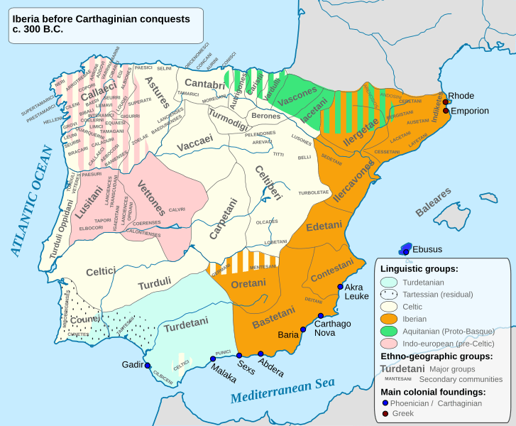
Description: Ethnographic and Linguistic Map of the Iberian Peninsula at about 300 BCE (before the Carthaginian conquests).
Title: Iberia 300BC-en
Credit: Based on the map done by Portuguese Archeologist Luís Fraga, from the "Campo Arqueológico de Tavira". The reference map can be found at this location [1]. Original source: https://web.archive.org/web/20161105032508/http://geohistorica.net/arkeotavira.com/Mapas/Iberia/Populi.pdf
Author: Alcides Pinto
Permission: I, the copyright holder of this work, hereby publish it under the following license:
Usage Terms: GNU Free Documentation License
License: GFDL
License Link: http://www.gnu.org/copyleft/fdl.html
Attribution Required?: Yes
Image usage
The following 43 pages link to this image:
- Arevaci
- Astures
- Ausetani
- Bastetani
- Belli
- Bergistani
- Berones
- Cantabri
- Caristii
- Carpetani
- Castellani people
- Ceretani
- Cessetani
- Contestani
- Cynetes
- Edetani
- Galicians
- Gallaeci
- History of Portugal
- Iacetani
- Ilercavones
- Ilergetes
- Indigetes
- Lacetani
- Laietani
- Lobetani
- Lusitanians
- Lusones
- Olcades
- Oretani
- Paesuri
- Pellendones
- Sedetani
- Tapoli
- Tartessos
- Titii (Celtiberian)
- Turboletae
- Turdetani
- Turduli
- Turduli Oppidani
- Turmodigi
- Vaccaei
- Varduli

All content from Kiddle encyclopedia articles (including the article images and facts) can be freely used under Attribution-ShareAlike license, unless stated otherwise.