
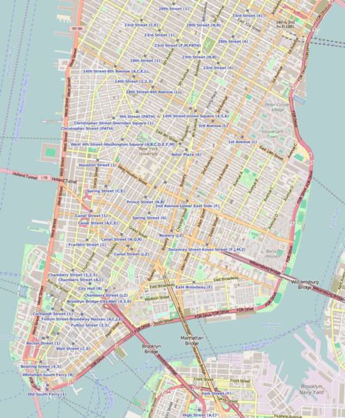
Image: Location map Lower Manhattan

Description: Map of Lower ManhattanThis map of Lower Manhattan was created from OpenStreetMap project data, collected by the community. This map may be incomplete, and may contain errors. Don't rely solely on it for navigation.
Title: Location map Lower Manhattan
Credit: You may find a page on the OpenStreetMap wiki page for Lower Manhattan, New York City, and a little more to the north
Author: OpenStreetMap contributors
Permission: OpenStreetMap data is available under the Open Database License (details). Map tiles are licensed under the Creative Commons Attribution-ShareAlike 2.0 license (CC-BY-SA 2.0). Contains map data © OpenStreetMap contributors, made available under the terms of the Open Database License (ODbL). The ODbL does not require any particular license for maps produced from ODbL data; map tiles produced by the OpenStreetMap foundation are licensed under the CC-BY-SA-2.0 licence, but maps produced by other people may be subject to other licences.Open Database LicenseODbLhttp://opendatacommons.org/licenses/odbl/1.0/true This file is licensed under the Creative Commons Attribution-Share Alike 2.0 Generic license. You are free: to share – to copy, distribute and transmit the work to remix – to adapt the work Under the following conditions: attribution – You must give appropriate credit, provide a link to the license, and indicate if changes were made. You may do so in any reasonable manner, but not in any way that suggests the licensor endorses you or your use. share alike – If you remix, transform, or build upon the material, you must distribute your contributions under the same or compatible license as the original. https://creativecommons.org/licenses/by-sa/2.0 CC BY-SA 2.0 Creative Commons Attribution-Share Alike 2.0 truetrue
Usage Terms: Creative Commons Attribution-Share Alike 2.0
License: CC BY-SA 2.0
License Link: https://creativecommons.org/licenses/by-sa/2.0
Attribution Required?: Yes
Image usage
The following 31 pages link to this image:
- 203 Prince Street
- 56 Pine Street
- Alfred E. Smith House
- Bayard–Condict Building
- Bouwerie Lane Theatre
- Bowery Savings Bank
- Bowling Green (New York City)
- Colonnade Row
- De Vinne Press Building
- Edward Mooney House
- Henry Street Settlement
- Hotel Chelsea
- John Street Methodist Church
- Judson Memorial Church
- Kehila Kedosha Janina
- Kitchen, Montross & Wilcox Store
- Lower East Side Tenement Museum
- Madison Square and Madison Square Park
- Marble Collegiate Church
- Meatpacking District, Manhattan
- Merchant's House Museum
- Old New York Evening Post Building
- Shearwater (schooner)
- South Street Seaport
- St. James Roman Catholic Church (Manhattan)
- St. Mark's Church in-the-Bowery
- St. Peter's Church (Manhattan)
- Stanton Street Synagogue
- Stonewall Inn
- Trinity Chapel Complex
- University Settlement Society of New York
