
Image: Locator map of Harrison County, Indiana

Size of this PNG preview of this SVG file: 600 × 600 pixels. Other resolution: 240 × 240 pixels.
Original image (SVG file, nominally 768 × 768 pixels, file size: 706 KB)
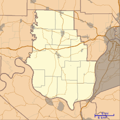
Description: This is a locator map of Harrison County, Indiana, USA which includes incorporated settlements, township borders, and major highways.
Title: Locator map of Harrison County, Indiana
Credit: My own work, using custom-written MapScript applications with United States Census Bureau data
Author: Omnedon
Usage Terms: Public domain
License: Public domain
Attribution Required?: No
Image usage
The following 16 pages link to this image:
- Bradford, Indiana
- Byrneville, Indiana
- Central, Indiana
- Central Barren, Indiana
- Corydon Historic District
- Depauw, Indiana
- Dogwood, Indiana
- Fishtown, Indiana
- Frenchtown, Indiana
- Glidas, Indiana
- Kintner–Withers House
- Macedonia, Indiana
- Ramsey, Indiana
- Swan's Landing Archeological Site
- Valley City, Indiana
- White Cloud, Indiana

All content from Kiddle encyclopedia articles (including the article images and facts) can be freely used under Attribution-ShareAlike license, unless stated otherwise.