Independence, Minnesota facts for kids
Quick facts for kids
Independence
|
|
|---|---|

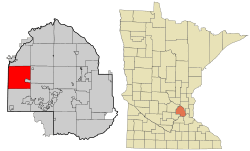
Location of the city of Independence
within Hennepin County, Minnesota |
|
| Country | United States |
| State | Minnesota |
| County | Hennepin |
| Area | |
| • City | 34.58 sq mi (89.55 km2) |
| • Land | 32.43 sq mi (84.00 km2) |
| • Water | 2.15 sq mi (5.56 km2) |
| Elevation | 978 ft (298 m) |
| Population
(2020)
|
|
| • City | 3,755 |
| • Density | 115.78/sq mi (44.70/km2) |
| • Metro | 3,279,833 |
| Time zone | UTC-6 (Central) |
| • Summer (DST) | UTC-5 (Central) |
| ZIP codes |
55357, 55359
|
| Area code(s) | 763 |
| FIPS code | 27-30842 |
| GNIS feature ID | 0645396 |
| Website | https://www.ci.independence.mn.us |
Independence is a small city in Hennepin County, Minnesota, United States. It is mostly made up of farms, thick forests, and many lakes. The city gets its name from Lake Independence, a large lake on its eastern side.
In 2020, about 3,755 people lived here. A major road, U.S. Highway 12, runs through the community.
Contents
Exploring Independence's Location
Independence is located about 24 miles (39 km) west of Minneapolis. The city covers an area of about 34.56 square miles (89.51 square kilometers). Most of this area, about 32.37 square miles (83.84 square kilometers), is land. The rest, about 2.19 square miles (5.67 square kilometers), is water, including its many lakes.
Independence's Population Over Time
The number of people living in Independence has grown steadily over the years. This chart shows how the population has changed.
| Historical population | |||
|---|---|---|---|
| Census | Pop. | %± | |
| 1860 | 223 | — | |
| 1870 | 502 | 125.1% | |
| 1880 | 842 | 67.7% | |
| 1890 | 1,035 | 22.9% | |
| 1900 | 1,368 | 32.2% | |
| 1910 | 1,427 | 4.3% | |
| 1920 | 1,269 | −11.1% | |
| 1930 | 1,184 | −6.7% | |
| 1940 | 1,207 | 1.9% | |
| 1950 | 1,203 | −0.3% | |
| 1960 | 1,446 | 20.2% | |
| 1970 | 1,993 | 37.8% | |
| 1980 | 2,640 | 32.5% | |
| 1990 | 2,822 | 6.9% | |
| 2000 | 3,236 | 14.7% | |
| 2010 | 3,504 | 8.3% | |
| 2020 | 3,755 | 7.2% | |
| U.S. Decennial Census | |||
Who Lives in Independence?
Based on the 2010 census, there were 3,504 people living in Independence. The city had about 108 people per square mile (41.7 people per square kilometer). Most residents were White (97.1%). Smaller groups included Asian (1.1%), African American (0.3%), and Native American (0.3%) people. About 1.3% of the population was Hispanic or Latino.
Many families live in Independence. About 37% of households had children under 18. The average age of people in the city was about 45.6 years old. About 26% of residents were under 18, and 12.5% were 65 or older.
See also
 In Spanish: Independence (Minnesota) para niños
 | William L. Dawson |
 | W. E. B. Du Bois |
 | Harry Belafonte |

