Indian River (Lanark County) facts for kids
For other places with the same name, see Indian River (disambiguation).
Quick facts for kids Indian River |
|
|---|---|

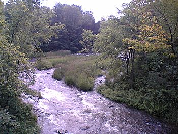
Indian River at the Mill of Kintail Conservation Area
|
|
|
Location of the mouth of the river in southern Ontario
|
|
| Country | Canada |
| Province | Ontario |
| Region | Eastern Ontario |
| County | Lanark |
| Municipalities |
|
| Physical characteristics | |
| Main source | Unnamed lake Lavant Township, Lanark Highlands 319 m (1,047 ft) 45°10′32″N 76°37′07″W / 45.17556°N 76.61861°W |
| River mouth | Mississippi River Ramsay Township, Mississippi Mills 94 m (308 ft) 45°15′24″N 76°14′32″W / 45.25667°N 76.24222°W |
| Basin features | |
| River system | Saint Lawrence River drainage basin |
| Tributaries |
|
The Indian River is a river located in Lanark County in Eastern Ontario, Canada. It is part of a larger water system called the Saint Lawrence River drainage basin. This means its waters eventually flow into the Saint Lawrence River. The Indian River is also a smaller stream, known as a tributary, that flows into the Mississippi River in Ontario.
Contents
Journey of the Indian River
The Indian River starts its journey from a lake that doesn't have a name. This lake is found in Lavant Township, which is part of the Lanark Highlands area.
Flowing East
- From its source, the river flows towards the east.
- It passes under Lanark County Road 511 near a small place called White.
- Then, it turns and flows southeast.
- The river goes past Halls Mills and reaches a larger body of water called Clayton Lake.
- At Clayton Lake, the river collects water from another lake called Taylor Lake.
Through Mississippi Mills
- After Clayton Lake, the river enters Ramsay Township, which is part of the town of Mississippi Mills.
- It flows out of Clayton Lake over the Clayton Lake Dam, near the community of Clayton.
- The river then heads northeast.
- It is joined by a smaller stream called Union Hall Creek.
The Mill of Kintail
- The Indian River flows through the Mill of Kintail Conservation Area. This area is special because it has an old grist mill. A grist mill is a building where grain was ground into flour.
- This area was also once the home of R. Tait McKenzie. He was a medical doctor and a sculptor who grew up in Ramsay Township.
- The old mill building now has a museum. It celebrates McKenzie and another famous person from Ramsay Township: James Naismith. He was the inventor of the sport of basketball!
Reaching the Mississippi River
- Finally, the Indian River reaches its end point, called its mouth.
- It flows into the Mississippi River. This meeting point is about 1.4 kilometers (0.87 miles) upstream from a place called Blakeney.
- The Mississippi River then flows into the Ottawa River, and the Ottawa River eventually joins the Saint Lawrence River.
Smaller Streams Joining the River
- Union Hall Creek (this stream joins the Indian River from the right side)
Black History Month on Kiddle
Famous African-American Activists:
 | William L. Dawson |
 | W. E. B. Du Bois |
 | Harry Belafonte |

All content from Kiddle encyclopedia articles (including the article images and facts) can be freely used under Attribution-ShareAlike license, unless stated otherwise. Cite this article:
Indian River (Lanark County) Facts for Kids. Kiddle Encyclopedia.

