Indian River (Muskoka District) facts for kids
Quick facts for kids Indian River |
|
|---|---|

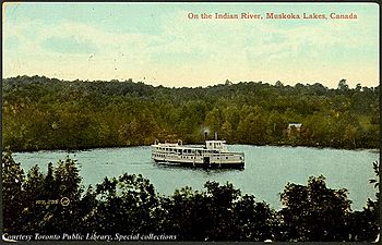
Steamship on the Indian River, 1910
|
|
|
Location of the mouth of the river in Ontario
|
|
| Country | Canada |
| Province | Ontario |
| Region | Central Ontario |
| District | Muskoka |
| Municipality | Muskoka Lakes |
| Physical characteristics | |
| Main source | Lake Rosseau 228 m (748 ft) 45°07′12″N 79°34′38″W / 45.12000°N 79.57722°W |
| River mouth | Lake Muskoka 226 m (741 ft) 45°05′37″N 79°33′44″W / 45.09361°N 79.56222°W |
| Basin features | |
| River system | Great Lakes Basin |
The Indian River is a cool river in Ontario, Canada. It's located in a beautiful area called Muskoka Lakes. This river is part of the huge Great Lakes Basin. It connects two important lakes: Lake Rosseau and Lake Muskoka.
Contents
About the Indian River
The Indian River flows through the Muskoka District in Central Ontario. It acts like a natural waterway connecting Lake Rosseau, which is upstream, to Lake Muskoka, which is downstream. This river is a vital part of the local water system.
How the River Flows
The river starts its journey from Lake Rosseau at a place called Port Carling Dam. From there, it flows through a narrow spot called the Forman Narrows. After that, it reaches Mirror Lake. Finally, the river ends its journey at Lake Muskoka near Hanna Point.
For a long time, it was hard for boats to travel between Lake Rosseau and Lake Muskoka. This changed in 1871. That year, a dam was built, and special water elevators called locks were created. These locks helped boats move up and down between the different water levels of the lakes.
Why Locks Were Important
Making the river easy to navigate was a big deal. It allowed large steamships to travel between the two lakes. This made it much easier for people to get around. It also helped new vacation spots and resorts grow around Lake Rosseau and Lake Joseph. People could now easily visit these beautiful areas by boat.
 | James Van Der Zee |
 | Alma Thomas |
 | Ellis Wilson |
 | Margaret Taylor-Burroughs |


