
Inis na Bró facts for kids
|
Native name:
Inis na Bró
|
|
|---|---|

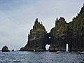
Inis na Bró, with Tearaght Island behind
|
|

Inishnabro
Location in island of Ireland
|
|
| Geography | |
| Coordinates | 52°03′28″N 10°36′33″W / 52.05786°N 10.60913°W |
| Archipelago | Blasket Islands |
| Area | 0.413 km2 (0.159 sq mi) |
| Highest elevation | 175 m (574 ft) |
| Administration | |
| County | County Kerry |
| Inishnabro | |
|---|---|
| Highest point | |
| Elevation | 175 m (574 ft) |
| Prominence | 175 m (574 ft) |
| Listing | Marilyn |
| Geography | |
| Location | County Kerry, Ireland |
| OSI/OSNI grid | V212930 |
Inishnabro (which means "island of the quern" or "bottom grind stone" in Irish) is one of the amazing Blasket Islands. These islands are located off the coast of County Kerry, in the country of Ireland.
Exploring Inishnabro's Geography
Inishnabro is a small island, but it's quite tall! It rises to 175 metres (about 574 feet) above the sea. The island covers an area of 41.3 hectares, which is about the size of 100 football fields. It is very close to another island called Inishvickillane, with only a narrow stretch of water, about 200 metres wide, separating them.
A Look at Inishnabro's History
In the early 1970s, something really interesting was suggested for Inishnabro. A space expert from the U.S. named Gary Hudson had an idea to use the island as a launch site for new rockets! This plan was kept secret for a long time. People only found out about it in 2003. That's when the Irish Government released old files from that time, following a rule that makes government documents public after 30 years.
Images for kids
-
The Cathedral Rocks on the island's northern coast

