Inkerman, Queensland facts for kids
Quick facts for kids InkermanQueensland |
|||||||||||||||
|---|---|---|---|---|---|---|---|---|---|---|---|---|---|---|---|

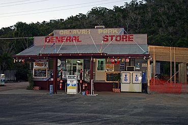
Caravan Park General Store, 2010
|
|||||||||||||||
| Population | 119 (2021 census) | ||||||||||||||
| • Density | 1.389/km2 (3.60/sq mi) | ||||||||||||||
| Postcode(s) | 4806 | ||||||||||||||
| Area | 85.7 km2 (33.1 sq mi) | ||||||||||||||
| Time zone | AEST (UTC+10:00) | ||||||||||||||
| Location |
|
||||||||||||||
| LGA(s) | Shire of Burdekin | ||||||||||||||
| State electorate(s) | Burdekin | ||||||||||||||
| Federal Division(s) | Dawson | ||||||||||||||
|
|||||||||||||||
Inkerman is a small rural town in Queensland, Australia. It is located in the Shire of Burdekin. In 2021, about 119 people lived in Inkerman.
Contents
Exploring Inkerman's Location
Inkerman is easy to find because the Bruce Highway runs along its western side. The North Coast railway line also follows this boundary.
Mountains and Hills in Inkerman
Even though most of Inkerman is flat, it has some interesting mountains. These include:
- Charlies Hill, which is 32 metres (105 feet) high.
- Mount Alma, standing at 104 metres (341 feet) tall.
- Mount Inkerman, the tallest at 219 metres (719 feet) high.
What the Land is Used For
The main activity in Inkerman is growing sugarcane. You will see many sugarcane fields here. Some areas are also used for grazing animals. This means animals like cattle eat the natural grass.
A Look Back at Inkerman's History
Inkerman has a simple but interesting history. It shows how the town has changed over time.
Early Services: Post Office and School
The Inkerman Post Office first opened around 1915. It was known as a "receiving office," which meant it handled mail. This office closed in 1975.
Inkerman State School welcomed its first students on 24 November 1915. It taught children for many years before closing on 31 December 1974. The old school buildings were still standing in 2008.
Who Lives in Inkerman?
The number of people living in Inkerman has changed over the years. In 2021, the population was 119 people.
Special Places: Heritage Listings
Inkerman has some places that are important to its history. These are called heritage-listed sites. They are protected because they tell us about the past.
The Radar Station on Charlie's Hill
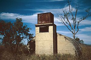
One important heritage site is the Radar Station, Charlie's Hill. It is located off Charlie's Hill Road. This old radar station played a role in history. You can still see its remains today.
Learning in Inkerman
There are no schools directly in Inkerman today. Students usually go to nearby towns for their education.
Nearby Schools for Students
For primary school, children attend Home Hill State School. For high school, students go to Home Hill State High School. Both of these schools are in Home Hill, which is a short distance away.
Fun Things to See and Do
Inkerman offers some great spots for visitors to enjoy the views and learn about the area.
Mount Inkerman Lookout
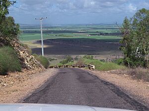
If you drive up Mount Inkerman Road, you will reach the top of Mount Inkerman. From here, you can see amazing views in every direction. It's a perfect spot for taking photos. There are also picnic areas where you can relax and have a snack.
Exploring Charlie's Hill
Charlies Hill also offers great views. You can see the remains of the old heritage-listed radar station there. To get to the top, you can use an unsealed road that branches off Charlies Hill Road.
 | Bessie Coleman |
 | Spann Watson |
 | Jill E. Brown |
 | Sherman W. White |


