
Interstate 470 (Ohio – West Virginia) facts for kids
Quick facts for kids
|
|||||||
|---|---|---|---|---|---|---|---|
| Lua error in Module:Infobox_road/map at line 15: attempt to index field 'wikibase' (a nil value).
Map of the Wheeling area with I-470 highlighted in red
|
|||||||
| Route information | |||||||
| Auxiliary route of I-70 | |||||||
| Maintained by ODOT and WVDOH | |||||||
| Length | 10.63 mi (17.11 km)
6.69 mi (10.77 km) in Ohio
3.94 mi (6.34 km) in W. Va. |
||||||
| Existed | 1976–present | ||||||
| Major junctions | |||||||
| West end | |||||||
| East end | |||||||
| Location | |||||||
| States: | Ohio, West Virginia | ||||||
| Counties: | OH: Belmont WV: Ohio | ||||||
| Highway system | |||||||
| Auxiliary route of the Interstate Highway System Main • Auxiliary • Business
|
|||||||

Interstate 470 (I-470) is a special highway that helps drivers get around the busy city of Wheeling, West Virginia. It's like a "loop" or "bypass" road that connects back to Interstate 70 (I-70) on both ends. This road is about 10.63 miles (17.11 km) long. It is managed by the transportation departments in both Ohio and West Virginia.
Contents
What is Interstate 470?
I-470 is a type of highway called an "auxiliary Interstate." This means it's a branch or loop off a main Interstate highway, which in this case is I-70. It was built to help traffic flow more smoothly around Wheeling. Instead of going through the city center, drivers can use I-470 to go around it.
Where Does I-470 Go?
The western end of I-470 starts near Blaine, Ohio, where it connects to I-70. From there, it travels southeast through Belmont County, Ohio. A big part of its journey is crossing the Ohio River on the Vietnam Veterans Memorial Bridge. This bridge is a major landmark on the route.
After crossing the river, the highway enters Ohio County, West Virginia. It then turns northeast, heading towards the Elm Grove area of Wheeling. The eastern end of I-470 connects back to I-70 near Wheeling Park. So, it forms a big curve around the city.
Why Was I-470 Built?
I-470 was officially opened in 1976. Its main purpose was to provide an easier way for drivers to travel through the region without having to go directly through downtown Wheeling. This helps reduce traffic in the city and makes journeys quicker for people passing through.
How Many Cars Use I-470?
Many vehicles use I-470 every day. On average, between 26,000 and 38,000 cars, trucks, and other vehicles travel on this highway daily. It's a very important road for both local people and those traveling long distances. For example, when the Wheeling Tunnel on I-70 needed repairs, I-470 was one of the main detour routes suggested to help drivers avoid the closed tunnel.
Images for kids
-
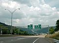
I-470 westbound at the US 250/WV 2 three-level diamond interchange
-
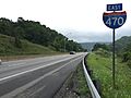
View east along I-470 past the CR 91/CR 1 exit in Bethlehem
-
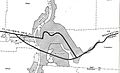
1955 map showing the planned routing of Interstate Highways through Wheeling

_in_Bethlehem,_Ohio_County,_West_Virginia.jpg)
.jpg)
