
Intragna facts for kids
Quick facts for kids
Intragna
|
||
|---|---|---|

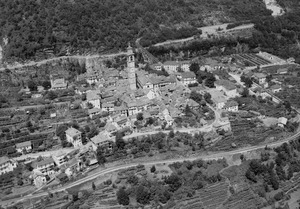
View from the surrounding mountains
|
||
|
||

Intragna
Location in Switzerland

Intragna
Location in Canton of Ticino
|
||
| Country | Switzerland | |
| Canton | Ticino | |
| District | Locarno | |
| Area | ||
| • Total | 24.1 km2 (9.3 sq mi) | |
| Elevation | 366 m (1,201 ft) | |
| Population | ||
| • Total | 885 | |
| • Density | 36.72/km2 (95.11/sq mi) | |
| Postal code |
6655
|
|
| Surrounded by | Ascona, Borgnone, Brissago, Cavigliano, Isorno, Losone, Mosogno, Palagnedra | |

Intragna is a lovely village in the Centovalli area of Ticino, Switzerland. It's part of the Locarno district.
This village has great train links to Locarno in Switzerland and Domodossola in Italy. You can also catch buses that take you to many cool hiking trails. Some of these trails even start or end right in Intragna!
Intragna is an old village with classic buildings and narrow, winding streets. You can find shops selling beautiful handmade lace and pottery. There are also several hotels if you want to stay. The church tower in Intragna is said to be the tallest in all of Ticino!
Contents
History of Intragna

People lived in the Intragna area a very long time ago. In 1897, some old graves were found. These graves show that people lived here even before 1000 BC, long before the Roman Empire came to Switzerland.
The modern village of Intragna was first written about in the year 1272. It was called Intranea back then.
During the Middle Ages, Intragna was controlled by different groups. These included the Bishop of Como and powerful families from Locarno. Intragna, along with two other villages, Golino and Verdasio, formed a "Vicinanza." This was like a local community group.
This "Vicinanza" had its own rules, first written in 1365. They could even send a representative to the main council of Locarno. The leader, called a mayor, was chosen from Intragna, Golino, or Verdasio in turns.
In the 16th to 18th centuries, Intragna was part of the Locarno region. In 1531, Intragna and some nearby villages tried to become independent from Locarno. But the Swiss Confederation said no.
Churches and Religious Life
The main religious center for the area used to be Golino. It had the Church of San Giorgio, built before 1297. Later, in 1474, a chapel called S. Gottardo was built in Intragna.
In 1653, Intragna got its own separate church area, or parish. The current church, S. Nome di Maria, was built between 1722 and 1738. Its famous bell tower was added later, from 1765 to 1775. At 65 meters (about 213 feet) tall, it is the highest in the Ticino canton.
Other nearby villages also formed their own parishes over time. For example, the church of S. Anna in Rasa was finished in 1753.
How People Lived and Worked
For a long time, most people in Intragna made their living from farming and raising animals. But by the 1950s, these jobs became less important.
Starting in the 16th century, many people left the village for parts of the year to find work. They often worked as chimney sweeps in places like Lombardy and Piedmont in Italy.
From 1631 to 1847, people from Rasa and some other villages had a special job. They had the only right to load goods at the Custom House in Livorno, Italy.
In the late 1800s, many people from Intragna moved far away. They went to countries like America and Australia to find new opportunities. Local factories, like a watch factory and a shoe factory, closed down by the 1960s.
Modern Connections and Changes

Life in Intragna changed with better transport. A main road was built between 1889 and 1893. Then, in 1923, a train station opened on the Domodossola – Locarno railway line.
Some parts of the area, like Pila, Costa, and Rasa, can only be reached by cable car. Rasa has had a cable car since 1958.
In 1929, a home for the elderly and nursing care opened in San Donato. Intragna is also home to the Regional Museum for the Centovalli and Terre di Pedemonte, which opened in 1989.
While the population in higher villages has dropped a lot, Intragna and Golino have grown since 1970. This is because they are closer to Locarno. By 2000, most people worked in service jobs. Many also traveled outside the village for work.
Intragna used to be its own municipality. But on October 25, 2009, it joined with the villages of Borgnone and Palagnedra. Together, they formed the new municipality of Centovalli.
Where is Intragna?
The former municipality of Intragna is in the Locarno district. The main village sits on a piece of land where the Isorno and Melezza rivers meet.
Many smaller villages and areas are part of Intragna. These include Golino, Verdasio, Pila, Vosa, Cremaso, Calezzo, Costa, Corcapolo, and Rasa. While Intragna and Golino are close to the Pedemonte area, most of the township is in the mountains of Centovalli.
Population Changes Over Time
The table below shows how the number of people living in Intragna has changed throughout history:
| Year | Population Intragna |
|---|---|
| 1653 | 604 |
| 1764 | over 1,000 |
| 1801 | 936 |
| 1850 | 1,428 |
| 1900 | 1,240 |
| 1950 | 957 |
| 1970 | 841 |
| 2000 | 915 |
