Invergarry Castle facts for kids
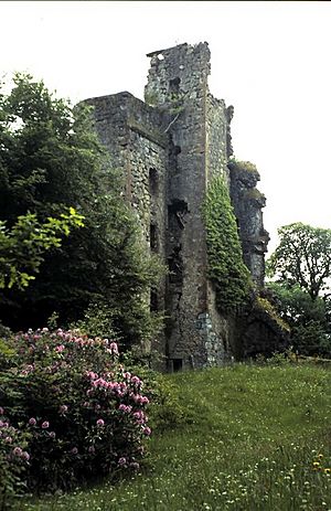
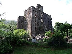
Invergarry Castle is a historic castle in the Scottish Highlands. It was once the main home for the Chiefs of the Clan MacDonell of Glengarry. This clan was a very strong part of the larger Clan Donald. The castle sits high above Loch Oich. It is on a spot called Creagan an Fhithich, which means "the Raven's Rock." This location was very important for protection during times of clan battles. We don't know exactly when the first building was put here. But we know there were at least two earlier structures before the castle we see today.
Contents
The Castle's Story
Building the Castle
After some attacks by the Clan Mackenzie in 1602, the MacDonells of Glengarry decided to make their home stronger. They built a large, six-story tower house. It was shaped like an 'L'. We don't know much about what the older castles looked like. Clan stories say the castle was built with stones. These stones were passed hand to hand by a long line of clansmen. They brought them all the way from Ben Tee mountain.
Wars and Rebellions
During the Civil War, soldiers led by General Monck burned the castle in 1654. He was fighting for Oliver Cromwell. The castle was fixed and then held for King James VII of Scotland from 1688. But it had to give up to the government in 1692.
The castle was also important during the Jacobite uprisings. These were times when people tried to bring the old royal family back to the throne. The Jacobites held the castle in 1715. But the government took it back in 1716.
Bonnie Prince Charlie's Visits
During the 1745 uprising, the castle was again held by the Jacobites. Prince Charles Edward Stuart, also known as "Bonnie Prince Charlie," visited the castle twice. He came shortly after starting the uprising. He is also said to have rested there after his defeat. This was after the Battle of Culloden in 1746.
The MacDonells were very involved in these uprisings. Lord MacDonnell was even part of the Prince's special council. After the Battle of Culloden, the castle was attacked. Soldiers working for the Duke of Cumberland partly blew it up. This was part of his plan to control the Highlands.
However, the castle's strong walls did not fully break. They have lasted for centuries. They remind us of the castle's long history. The Duke of Cumberland's men likely felt they had damaged the castle enough. They removed the southeast wall and destroyed the northwest 'L' part. The castle was never rebuilt. The MacDonells moved to a new home called Invergarry House. This new house was started a few years later.
Later, the Glengarry lands were sold. But Invergarry Castle, Invergarry House, the "Well of Heads," and the old clan burial ground were kept. They were passed down through the family.
How the Castle Looked
The castle we see today was finished around 1670. By 1691, it was an 'L' shaped building. It had a large staircase leading to the first floor. The main building was five stories tall. The tower part was six stories high. The main building was about 55 by 32 feet (17 by 10 meters). The main hall was on the first floor. It was about 44 by 20 feet (13 by 6 meters). The main door was on the north side of the castle's northwest wing. The kitchens were probably in the basement.
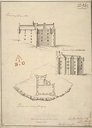
In its time, Invergarry Castle was an older style of building in Scotland. It was more like a large country house than a true fortress. Today, it is mostly ruins. So, it's hard to imagine how it looked when it was new. But we have a very good drawing from 1714. It was made by the Board of Ordnance. These drawings were very careful and correct. So, we can trust that it shows the castle as it really was.
This drawing helped Charles McKean create a picture of how the castle might have looked. The castle was simpler than some others. But it had a tall, narrow shape. It also had small towers called 'bartizans' on its walls. It did not have strong defensive walls on top. Even with thick walls, a building like Invergarry would not have survived a big military attack. The 'L' wing had an open staircase. This offered little protection.
On the ground floor, the castle had some ways to defend itself. These included small holes for shooting and barred windows. It also had a strong door, probably made of iron. Some walls were very thick. This might be because they used parts of an older castle. Or it was just to make the five-story building strong. The inside of the castle, especially the hall, would have been very grand. It might have had painted ceilings and white walls. There would have been wall hangings like tapestries. It also had a large fireplace and nice furniture.
Outside, the castle had a courtyard. This area would have had other buildings. These included stables, workshops, a bakery, and a brewery. These were all needed for daily life. There was also likely a wall around this courtyard. All signs of these outer buildings are now gone.
The Castle Today
In 1960, the Castle, the Well of Heads, and the burial ground were given to a special group. This group is called the 'Invergarry Castle Preservation Trust'. This trust is not connected to the National Trust for Scotland.
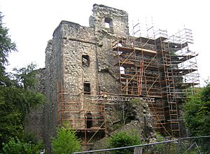
Around the year 2000, a part of the castle fell down. The remaining north staircase collapsed. This led to a project in 2007 to make the castle stronger. This work was guided by Historic Scotland, which is now Historic Environment Scotland. They put strong beams inside to help hold it up. The ruined castle is now a protected historic site.
In 1957, a newspaper called The Glengarry News asked for help. It asked all members of Clan Donald to donate money to save Invergarry Castle. In 1960, Invergarry House became the Glengarry Castle Hotel. It has a great view of Loch Oich. The ruins of Invergarry Castle are also on its grounds.
About the Old Drawing
Brigadier General Lewis Petit des Etans was a French engineer. He worked for the British Army for almost 30 years. In 1714, he was sent to Scotland. He was in charge of a group of engineers from the Board of Ordnance. This was because there was a threat of a Jacobite uprising in northern Scotland. One of their jobs was to draw all buildings that could be important for military reasons.
The National Library of Scotland has 18 drawings that Petit signed. Petit was the commanding officer. So, it's not likely he did the actual measuring himself. The drawing shows a map and pictures of the castle from different sides. It is called the 'Castle of Glangary' on the drawing.
The map shows how important the main staircase was. The pictures show the tall, narrow shape of the building. They show several small towers (bartizans) and a small room on the roof (cap-house). But they don't show other defenses on top of the walls. The drawing does not show any outer walls or service buildings. This might be because it was made for military reasons. So, they might not have thought these details were needed.
(This drawing is used with permission from the National Library of Scotland.)
 | May Edward Chinn |
 | Rebecca Cole |
 | Alexa Canady |
 | Dorothy Lavinia Brown |


