Irishtown Bend facts for kids
Quick facts for kids |
|
|
Irishtown Bend Archeological District
|
|
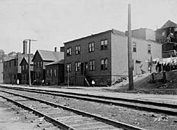
Historic view of Irishtown Bend, c. 1922
|
|
| Nearest city | Cleveland, Ohio |
|---|---|
| Area | 6.9 acres (2.8 ha) |
| NRHP reference No. | 90000757 |
| Added to NRHP | May 25, 1990 |
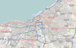
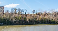
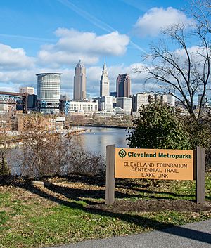
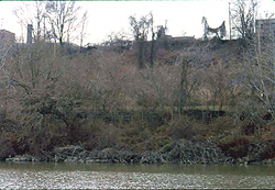
Irishtown Bend is a special place in Cleveland, Ohio. It's known for two things: an old neighborhood where many Irish Americans lived, and a unique shape of land along the Cuyahoga River. This landform includes a sharp curve in the river and a steep hillside right above it.
The neighborhood started around 1830 when Irish immigrants moved there. Later, in the late 1800s, some parts of the area became industrial. By 1900, most Irish families had moved away, and new immigrants from Eastern Europe settled there. The neighborhood slowly disappeared for different reasons, and the last buildings were removed by the late 1950s.
By the 1980s, no homes or businesses were left. That's when archaeologists started digging to learn about the past. In 1990, a part of the area, called the Irishtown Bend Archeological District, was added to the National Register of Historic Places. Since 2006, people have been working to make the hillside stable, protect the historical findings, and turn the whole area into a park.
Contents
Why the Irishtown Bend Hillside is Unstable
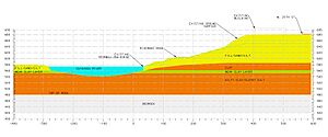
The land at Irishtown Bend has a very interesting history, going back millions of years. Long ago, huge glaciers covered Ohio. As these glaciers moved and then melted, they left behind many layers of soil and rock.
The ground here is made up of different layers:
- Hard bedrock (like shale) at the bottom.
- About 40 to 60 feet (12 to 18 meters) of tough glacial soil.
- Then, layers of stiff clay, weak clay, silt, and sand.
- On top, there's about 10 to 20 feet (3 to 6 meters) of "fill dirt." This is extra soil that was added by people.
Because of these many layers, the hillside is not very stable. It's actually sliding into the river slowly, about 2 inches (5 centimeters) each year. In the late 1950s and early 1960s, a lot of extra dirt was added to the slope. This made the sliding much faster.
You can even see cracks in the ground at the top of the hill and along Franklin Avenue. These cracks show that the hill is still moving. Water in the soil also makes the problem worse. Since about 2004, the sliding has sped up a lot, causing big cracks in Riverbed Street, which had to be closed for safety.
The Irishtown Bend Neighborhood: A Look Back
The Irishtown Bend land is on the west side of the Cuyahoga River in Cleveland. It stretches for about 2,500 feet (760 meters) from Columbus Road to the Detroit–Superior Bridge. The top of the hill is about 100 feet (30 meters) above the river.
How the Neighborhood Started
Irishtown Bend was part of a bigger Irish community in Cleveland called "the Angle." The first large group of Irish people came to Cleveland around 1825. Many had worked on the Erie Canal and settled here when that work ended. Because of unfair treatment against Irish people, they often had to live in certain areas.
Irishtown Bend became a home for Irish immigrants in the 1850s, especially after the Irish Potato Famine caused many Irish people to move to the United States. By 1870, about 10% of Cleveland's 100,000 residents were Irish. Most people living in Irishtown Bend after 1850 were laborers, meaning they worked with their hands. The city set up 80 plots of land for homes there.
The "Shanty Town" Myth
You might hear Irishtown Bend called a "shanty town" in old stories or news articles. A shanty town is a place with poorly built shacks. Some historians even said that most homes here were shacks built on stilts over the steep ground.
However, archaeological digs by the Cleveland Museum of Natural History in the 1980s showed a different story. They found evidence of strong, well-built wooden homes, many with stone or concrete foundations. The neighborhood was a working-class area, not a poor one. Most homes were one or two stories tall. For example, one home from the 1850s or 1860s had a basement with stone walls and a brick floor! Even a widow's home from before 1872 had a brick foundation and was two stories high.
Pictures from that time also show a community of well-built homes on level ground. It seems the idea of Irishtown Bend being a "shanty town" came from negative feelings against Irish immigrants, rather than the truth.
A New Community: Eastern European Immigrants
Between 1860 and 1880, Irishtown Bend started to change. Instead of new Irish immigrants, most residents were now first-generation Irish Americans (children of immigrants). Then, starting in 1880, immigrants from Eastern Europe, especially Hungarians, began to move in. By 1900, half the people living in Irishtown Bend were from Eastern Europe, even though Irish Americans still owned most of the land. Both the Irish Americans and the new immigrants living there were often skilled or semi-skilled workers.
At its busiest, Irishtown Bend had 119 buildings, including 78 homes where 138 families lived.
Why the Neighborhood Disappeared
Around 1898, people started leaving Irishtown Bend to find better homes elsewhere. Also, new rules limited how many immigrants could come to the country, so fewer new people moved in to replace those who left. By 1912, a third of the homes had been torn down, and many others were empty. Some temporary shacks were built during this time. A large warehouse, the Lederer Terminal Warehouse, opened in the area around 1920.
During the 1930s Great Depression, a "Hooverville" (a shanty town built by homeless people) grew on the empty land at Irishtown Bend. Many of the stories about the area being a "shanty town" actually come from this period, not from when the Irish community lived there.
By 1952, only five homes were left, and they were all empty. What little remained of Irishtown Bend was finally removed in the mid to late 1950s.
Other Important Structures at Irishtown Bend
Over the years, many other things were built at Irishtown Bend besides homes.
Railroads and Docks
Railroads were very important for moving goods in Cleveland. In the late 1800s, a railroad line was extended around Irishtown Bend to reach the river. Docks were built along the river to load and unload goods from trains onto ships. The area was so busy that the railroad had a large rail yard with eight tracks along Irishtown Bend.
Making the River Wider
The Cuyahoga River in Cleveland has some very tight curves. As large ships became more common in the late 1800s, these curves made it hard for them to pass. The city and the U.S. Army Corps of Engineers worked for decades to widen the river in many places, including Irishtown Bend. Steel walls called "bulkheads" were built along the riverbank to hold back the land. This work started in 1940 but was paused during World War II. It was finally finished in 1958.
Sewers, Bridges, and Public Housing
Around 1900, a brick sewer was built along what is now Riverbed Street. Later, in 1947, a large sewer tunnel was built about 30 feet (9 meters) below Riverbed Street. However, this tunnel was poorly designed and built in an area that was known to slide.
In 1914, construction began on the Detroit–Superior Bridge at the north end of Irishtown Bend. The railroad tracks ran under one of its arches.
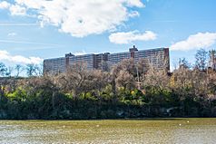
In 1959, the Cleveland Metropolitan Housing Authority (CMHA) bought land at Irishtown Bend to build public housing. Their 15-story Riverview Towers opened in 1964, along with other smaller apartment buildings. A lot of fill dirt was added to the hillside during this construction, which unfortunately made the existing land slides worse and started new ones.
Over time, other changes were made, like moving a street intersection and widening Riverbed Street.
Damage from Sliding Soil
Problems with water soaking into the northern part of Irishtown Bend and making the hill unstable were first noticed in 1960. Railroad tracks sank and had to be fixed. A landslide happened in 1966, likely due to a broken water or sewer pipe. Drains were built to help guide water away from the slope. By 1989, a lot of water was seeping out of the hill and onto Riverbed Street.
Around 2004 or 2005, the Irishtown Bend hill started sliding much faster. In 2005, big cracks appeared in Riverbed Street. Even after the city repaved it, cracks came back just two weeks later, and the street had to be closed. By 2007, parts of the street had dropped by more than 4 feet (1.2 meters).
After many years of studies, local leaders decided in 2015 on a plan to stabilize the hillside. This plan costs about $49 million. Fixing the roads and sewers, building a "lake link" trail, and creating a new public park are all part of this big project.
Future Plans: A Park and Trail
In 1987, an archaeologist named Dr. Alfred M. Lee started digging at Irishtown Bend. His work helped people realize how important it was to save this historical site and make it open to the public.
In 1992, a report suggested creating a long series of parks, trails, and protected areas to connect Lake Erie with the Cuyahoga Valley National Park. This plan included biking and hiking trails at Irishtown Bend to link it with other areas.
Because the hillside was so unstable, it became clear that the area shouldn't be used for important buildings. So, in 2006, the city of Cleveland and other groups started talking about turning the abandoned railroad tracks and hillside into a park. In 2009, they released a plan called the "Flats Connections Plan." It suggested turning the old tracks into a biking and hiking trail and building a new bridge for people to cross the river. The plan also proposed turning the Irishtown Bend hillside into a park with playgrounds and wetlands.
The Cleveland Foundation Centennial Lake Link Trail
Work on designing the trail began in 2009. Large donations from groups like The George Gund Foundation and The Cleveland Foundation helped fund the project. In honor of The Cleveland Foundation's gift, the path was named the Cleveland Foundation Centennial Lake Link Trail.
The trail was built in three parts. The southern part opened in 2015, and the northern part opened in 2017. The middle section, which goes through Irishtown Bend, is waiting for the hillside to be stabilized before it can be built.
A Potential Park for Everyone
The Cleveland-Cuyahoga County Port Authority took charge of finding a way to stabilize the soil at Irishtown Bend in 2012. While an earlier estimate for fixing the hillside was very high, a new study in 2015 brought the cost down to about $49 million.
Different groups, including Ohio City Inc. and LAND Studio, are working together to design the new park. This park will be about 17 acres (69,000 square meters) and will include the top of the hillside, a farm area, and other spaces.
Public meetings about the park design started in 2017. A new design was shown in late 2017, proposing four different zones for the park:
- Ohio City Farms: This existing farm area would be part of the park.
- Neighborhood Park and Playground: A place for local families to enjoy.
- History Zone: This area would have boardwalks over excavated archaeological sites, letting visitors see the past.
- Riverfront Zone: Along the river, there would be a walking path and a man-made wetland.
Paths will zigzag through the park, connecting all the zones. There's even a plan for a 22-foot (6.7-meter) high walkway in the neighborhood park and history zones. This walkway would let people easily get to residential areas north of the park. The proposed park design was submitted for approval in September 2017.
In 2018, the state of Ohio approved $2.5 million to help stabilize Irishtown Bend. Cuyahoga County also leased two acres of land to the park planners for a very low cost, showing their support for the project.
Irishtown Bend Archeological District
The Irishtown Bend Archeological District is a historic site within Irishtown Bend. It's important because it holds clues about the past.
Between 1987 and 1989, archaeologists from the Cleveland Museum of Natural History dug up the sites of three old homes in the Irishtown Bend neighborhood. They used old records and family histories to learn about the families who lived there. The objects they found (called artifacts) helped them understand how these families lived and how much money they had.
These archaeological discoveries made people realize how important it was to protect the site and make it available for people to learn from.
The Irishtown Bend Archeological District was added to the National Register of Historic Places on May 25, 1990. It covers the area where the homes were located in the 1800s. Even though some parts of the area were changed by later buildings, much of the important archaeological evidence is still there, buried under about 2 to 7.5 feet (0.6 to 2.3 meters) of soil. This soil came from grading the land, dumping, erosion, and possibly from people living there during the Great Depression.
The Irishtown Bend Archeological District is not currently open to the public, but you can see it from Riverbed Road.
 | Charles R. Drew |
 | Benjamin Banneker |
 | Jane C. Wright |
 | Roger Arliner Young |


