Irondale, Ohio facts for kids
Quick facts for kids
Irondale, Ohio
|
|
|---|---|
|
Village
|
|

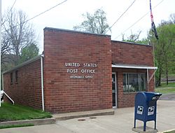
Irondale Post Office sits near Yellow Creek
|
|

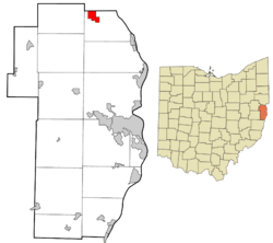
Location of Irondale in Jefferson County and in the state of Ohio
|
|
| Country | United States |
| State | Ohio |
| County | Jefferson |
| Township | Saline |
| Area | |
| • Total | 1.48 sq mi (3.82 km2) |
| • Land | 1.45 sq mi (3.75 km2) |
| • Water | 0.03 sq mi (0.07 km2) |
| Elevation | 719 ft (219 m) |
| Population
(2020)
|
|
| • Total | 326 |
| • Density | 224.98/sq mi (86.85/km2) |
| Time zone | UTC-5 (Eastern (EST)) |
| • Summer (DST) | UTC-4 (EDT) |
| ZIP code |
43932
|
| Area code(s) | 330 |
| FIPS code | 39-37422 |
| GNIS feature ID | 2398274 |
Irondale is a small village located in northern Jefferson County, Ohio, in the United States. In 2020, about 326 people lived there. Irondale is part of the larger Weirton–Steubenville metropolitan area.
Contents
Irondale's Early History
Irondale was first known as Pottsdale. This name came from Samuel Potts, who started a salt business around 1806 near Yellow Creek. Later, in 1869, a new plan for the town was made by Morgan & Hunter. They called it Hunterville.
The town's name changed to Irondale because people found iron ore and other minerals there. These minerals were important for making tin. Coal mining also began in the area in 1861. A special furnace was built to make iron for the tin mill. This is how the town got its current name, Irondale. The first successful tin mill in the United States started operating in Irondale in the 1880s.
Geography of Irondale
Irondale covers a total area of about 1.48 square miles (3.82 square kilometers). Most of this area, about 1.45 square miles (3.75 square kilometers), is land. A small part, about 0.03 square miles (0.07 square kilometers), is water.
Irondale's Population Over Time
| Historical population | |||
|---|---|---|---|
| Census | Pop. | %± | |
| 1870 | 751 | — | |
| 1880 | 399 | −46.9% | |
| 1890 | 694 | 73.9% | |
| 1950 | 775 | — | |
| 1960 | 705 | −9.0% | |
| 1970 | 602 | −14.6% | |
| 1980 | 535 | −11.1% | |
| 1990 | 382 | −28.6% | |
| 2000 | 418 | 9.4% | |
| 2010 | 387 | −7.4% | |
| 2020 | 326 | −15.8% | |
| U.S. Decennial Census | |||
Population Details from 2010
According to the census from 2010, 387 people lived in Irondale. There were 142 households and 104 families. The village had about 267 people per square mile (103 people per square kilometer).
Most of the people living in Irondale were White (99.7%). A small number were African American (0.3%).
About 37% of the households had children under 18 years old. More than half (51.4%) were married couples living together. The average household had 2.73 people. The average family had 3.19 people.
The average age of people in the village was 36.1 years. About 28% of residents were under 18. About 12% were 65 years or older. Slightly more males (53%) lived in Irondale than females (47%).
Education in Irondale
Students in Irondale attend public schools managed by the Edison Local School District. Younger students go to Stanton Elementary School. This school teaches students from preschool up to 8th grade. Older students attend Edison High School [1]. This high school serves students in grades 9 through 12.
See also
 In Spanish: Irondale (Ohio) para niños
 | Claudette Colvin |
 | Myrlie Evers-Williams |
 | Alberta Odell Jones |

