
Itumbiara facts for kids
Quick facts for kids
Itumbiara
|
|||
|---|---|---|---|
|
Municipality
|
|||
| Municipality of Itumbiara | |||
|
|||

Location in the state of Goiás.
|
|||
| Country | |||
| Region | Meia Ponte Microregion | ||
| State | Goiás | ||
| Founded | October 12, 1909 | ||
| Area | |||
| • Total | 2.461.280 km2 (0.95 sq mi) | ||
| Elevation | 448 m (1,470 ft) | ||
| Population
(2022)
|
|||
| • Total | 107,970 | ||
| • Density | 37.71/km2 (97.7/sq mi) | ||
| Time zone | UTC−3 (BRT) | ||
| HDI (2010) | 0,752 – high | ||
| Website | City of Itumbiara | ||


Itumbiara is a city in the very south of the state of Goiás, Brazil. In 2022, about 107,970 people lived there. The city covers an area of about 2,461 square kilometers. Itumbiara is known as one of the richest cities in Goiás. It produces a lot of soybeans, corn, and milk, and also raises many cattle.
Contents
About Itumbiara's Location
Itumbiara is located 197 kilometers south of Goiânia, which is the capital city of the state. It sits right on the border with the state of Minas Gerais.
How to Get There
You can reach Itumbiara by road from Goiânia. There are also roads connecting it to São José do Rio Preto in the state of São Paulo. These roads are part of the national highway, BR 153.
Nearby Attractions
Brazil's famous hot springs, Caldas Novas and Rio Quente, are not far away to the north.
Rivers and Waterways
Several important rivers flow through Itumbiara. These include the Paranaíba River, the Meia Ponte, and the Rio dos Bois. Many smaller rivers and streams also cross the area.
Small Towns Nearby
The municipality of Itumbiara also includes smaller towns called Campo Limpo and Meia Ponte.
Population Details
- In 2015, there were about 37.71 people living per square kilometer.
- The population grew by about 1.04% between 1996 and 2007.
- The total population in 2015 was 100,548.
- In 1980, the total population was 78,049.
- Most people live in the city (89,000 in 2010), while fewer live in rural areas (3,942 in 2010).
Itumbiara's History
In 1824, a new road was finished. It connected Uberaba to Anhanguera, right on the border between Goiás and Minas Gerais. The government set up a place to collect taxes there. This spot was first called "Porto de Santa Rita" or simply "Porto."
Soon, a small church was built and dedicated to Santa Rita. Because of this, the settlement became known as Santa Rita do Paranaíba. This name honored the large Paranaíba River, which separates Minas and Goiás.
In 1909, a special bridge called a suspension bridge was built over the river. That same year, Santa Rita do Paranaíba officially became a municipality (a city with its own local government).
In 1943, the city's name was changed to Itumbiara. This name comes from a Tupi–Guarani language and means "Pathway to the Waterfall." It was named after a road built by Engineer Inácio Pais Leme. This road connected the town to Cachoeira Dourada, which is about 40 kilometers away. In 1966, Itumbiara became the main city for the Roman Catholic Diocese of Itumbiara.
Itumbiara's Economy
Itumbiara is very important for farming in Brazil. It produces a lot of corn, soybeans, and cotton.
Farming and Animals
The city has many animals, too. There are almost 150,000 beef cattle and 30,000 milking cows. Itumbiara also has a large poultry industry, raising many chickens.
- Poultry: 429,220 chickens (in 2006)
- Cattle: 152,640 cows
- Pigs: 14,990 pigs
- Milking Cows: 32,030 cows
Main Crops Grown
Here are some of the main crops grown in Itumbiara and the area they cover:
- Cotton: 900 hectares
- Rice: 1,400 hectares
- Sugarcane: 11,500 hectares
- Corn: 6,550 hectares
- Soybeans: 36,500 hectares
- Sorghum: 5,300 hectares
Important Businesses
Itumbiara has several large businesses that process farm products:
- Alca Foods (makes cereals)
- Braspelco (exports leather)
- Caramuru Alimentos (a big food business that exports soy)
- Grupo Maeda (deals with cotton and soy)
- Pioneer Sementes (sells seeds for planting)
Other Businesses
- Factories: In 2007, there were 167 factories. The main industrial area is called Distrito Agroindustrial (DIAGRI).
- Dairies: Companies that process milk include Coop. Central de Laticínio do Estado de SP Ltda., Miqueline e Miqueline Ltda., and Marajoara Ind. de Laticínios Ltda.
- Banks: Many banks have branches in Itumbiara, such as Banco do Brasil, Bradesco, Itaú, and HSBC.
- Shops: In 2007, there were 1,180 retail shops in the city.
Education in Itumbiara
In 2006, Itumbiara had 58 schools. A total of 25,464 students attended these schools. Most people in the city can read and write, with a literacy rate of 89.0% in 2000.
Higher Education
As of July 2007, there were three colleges or universities in Itumbiara:
- ULBRA (Lutheran University of Brazil)
- UEG (Universidade Estadual de Goiás)
- UNIFASC (Faculdade Santa Rita de Cássia)
Fun Things to Do in Itumbiara
Itumbiara is a great place for water sports and other fun activities.
Water Activities
The city's main attraction is its beautiful artificial lake, Itumbiara. You can do all sorts of water sports there, like boating or jet skiing. Every year, on the second Sunday of August, there's a traditional river parade called Our Lady of the Graces.
Nature Spots
Other cool places to visit include the Vermelhão Lake and two waterfalls: Salto de Santa Maria de Cima and Saltos de Santa Maria do Meio.
Famous Bridge
The Affonso Penna Bridge, also known as the "Crystal Bridge," is a famous landmark. It connects the states of Goiás and Minas Gerais.
Sports and Events
Itumbiara also has a Kart circuit. This track hosts local, national, and even international karting races. It can hold up to 5,000 people!
Airport
The city has its own airport, called Francisco Vilela do Amaral Airport.
Sports in Itumbiara
The city has a football (soccer) team called Itumbiara EC. They played in Brazil's top league, the Série A, in 1979. In 2008, they won the state championship. Their home stadium is called Estádio JK.
Sister Cities
Itumbiara has special connections with two other cities in Brazil:
Famous People from Itumbiara
Some well-known people were born or grew up in Itumbiara:
- Dante do Amaral, a famous volleyball player
- Zé Roberto, a football (soccer) player
- Jorge e Mateus, popular Sertanejo singers
- Ricardo Boiadeiro, a football (soccer) player
Itumbiara's Climate
| Climate data for Itumbiara (1981–2010) | |||||||||||||
|---|---|---|---|---|---|---|---|---|---|---|---|---|---|
| Month | Jan | Feb | Mar | Apr | May | Jun | Jul | Aug | Sep | Oct | Nov | Dec | Year |
| Mean daily maximum °C (°F) | 31.1 (88.0) |
31.7 (89.1) |
31.2 (88.2) |
31.0 (87.8) |
29.3 (84.7) |
28.9 (84.0) |
29.9 (85.8) |
31.9 (89.4) |
33.8 (92.8) |
33.6 (92.5) |
32.3 (90.1) |
31.3 (88.3) |
31.3 (88.3) |
| Daily mean °C (°F) | 25.2 (77.4) |
25.3 (77.5) |
25.0 (77.0) |
24.3 (75.7) |
21.8 (71.2) |
20.8 (69.4) |
21.2 (70.2) |
23.2 (73.8) |
25.6 (78.1) |
26.4 (79.5) |
25.7 (78.3) |
25.4 (77.7) |
24.2 (75.6) |
| Mean daily minimum °C (°F) | 21.2 (70.2) |
20.9 (69.6) |
20.7 (69.3) |
18.9 (66.0) |
15.5 (59.9) |
14.1 (57.4) |
13.7 (56.7) |
15.7 (60.3) |
19.1 (66.4) |
20.4 (68.7) |
20.9 (69.6) |
21.3 (70.3) |
18.5 (65.3) |
| Average precipitation mm (inches) | 267.8 (10.54) |
201.1 (7.92) |
179.1 (7.05) |
71.9 (2.83) |
30.4 (1.20) |
12.7 (0.50) |
4.6 (0.18) |
7.2 (0.28) |
50.3 (1.98) |
84.8 (3.34) |
193.1 (7.60) |
255.3 (10.05) |
1,358.3 (53.48) |
| Average precipitation days (≥ 1.0 mm) | 16 | 13 | 13 | 5 | 3 | 1 | 1 | 1 | 4 | 8 | 12 | 16 | 93 |
| Average relative humidity (%) | 78.2 | 77.0 | 77.2 | 72.7 | 69.3 | 64.9 | 57.4 | 49.0 | 52.0 | 59.4 | 69.7 | 75.8 | 66.9 |
| Mean monthly sunshine hours | 162.5 | 174.7 | 200.5 | 237.1 | 246.7 | 253.0 | 273.7 | 284.7 | 224.7 | 212.9 | 182.2 | 167.2 | 2,619.9 |
| Source: Instituto Nacional de Meteorologia | |||||||||||||
Images for kids
-
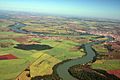
The Paranaíba River, which flows near Itumbiara.

See also
 In Spanish: Itumbiara para niños
