São José do Rio Preto facts for kids
Quick facts for kids
São José do Rio Preto
|
|||
|---|---|---|---|
|
Municipality
|
|||
| Municipality of São José do Rio Preto | |||
|
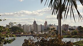
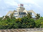
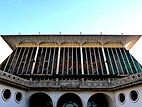
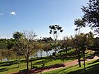
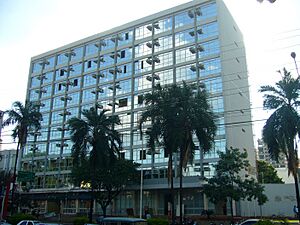
From top, and left to right: Downtown area; Paulo Moura Theater; Public Library; Diocese of São José do Rio Preto; Parque da Represa.
|
|||
|
|||
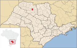
Location in São Paulo
|
|||
| Country | |||
| Region | Southeast | ||
| State | |||
| Mesoregion | São José do Rio Preto | ||
| Founded | March 19, 1852 | ||
| Area | |||
| • Municipality | 431.30 km2 (166.53 sq mi) | ||
| • Urban | 124,79 km2 (4,818 sq mi) | ||
| Elevation | 489 m (1,604 ft) | ||
| Population
(2022)
|
|||
| • Municipality | 480,439 | ||
| • Density | 1,112.27/km2 (2,880.8/sq mi) | ||
| Time zone | UTC-3 (UTC-3) | ||
| Postal Code |
15000-000
|
||
| Area code(s) | +55 17 | ||
| HDI | 0.797 – high | ||
São José do Rio Preto is a city in the state of São Paulo, Brazil. It is located in the northwest part of the state. The city is about 440 kilometers (273 miles) from São Paulo city. It is also about 700 kilometers (435 miles) from Brasília.
In 2021, São José do Rio Preto had a population of 469,173 people. This makes it the 11th largest city in São Paulo. It is also the 36th largest city in Brazil. The city was founded in 1852. Its history is linked to trade, services, and farming.
São José do Rio Preto is the main city of its region. This area has a population of over 1.5 million people. The city celebrates its birthday on March 19th. This is the same day as Saint Joseph's Day.
Contents
History of São José do Rio Preto

Before the 1800s, the Kaingang indigenous people lived in the São José do Rio Preto area. Over time, their numbers went down. This was due to people moving, explorations, and mixing with other groups.
The city was started on March 19, 1852. A person from Minas Gerais named João Bernardino de Seixas Ribeiro founded it. A local farmer, Luiz Antônio da Silveira, gave some of his land. He did this to create the new city. It was named after the patron saint, Saint Joseph.
São José do Rio Preto officially became a city in 1894. It was no longer part of Jaboticabal. A railway reached the city in 1912. This railway was very important for the city's growth. São José do Rio Preto became a trading center. It was also a place to store and move goods to and from São Paulo.
What Does "São José do Rio Preto" Mean?
The name São José do Rio Preto means "Saint Joseph of the Black River." "São José" refers to Saint Joseph, who is the city's patron saint. "Rio Preto" means "black river." This is the name of the river that flows through the city.
Between 1906 and 1944, the city was just called Rio Preto. In 1944, there was an idea to change the name to Iboruna. This means "Black River" in the Tupi language. But this name change did not happen.
Geography and Climate
São José do Rio Preto is in the northwest of São Paulo state. It is located between the Grande, Paraná, and Tietê rivers. The area has a mix of Cerrado (Brazilian savanna) and parts of the Atlantic Forest. The land is mostly gently rolling hills. The average height above sea level is 489 meters (1,604 feet).
Weather in São José do Rio Preto
The climate in São José do Rio Preto is tropical. This means it has hot and rainy summers. The winters are mild and dry.
The average temperature each year is about 23°C (73°F). The city usually gets 1,300 to 1,500 millimeters (51 to 59 inches) of rain per year. In 2008, the city received 1,593 millimeters (62.7 inches) of rain.
| Climate data for São José do Rio Preto (1994–2010) | |||||||||||||
|---|---|---|---|---|---|---|---|---|---|---|---|---|---|
| Month | Jan | Feb | Mar | Apr | May | Jun | Jul | Aug | Sep | Oct | Nov | Dec | Year |
| Mean daily maximum °C (°F) | 32.1 (89.8) |
32.6 (90.7) |
32.3 (90.1) |
31.5 (88.7) |
27.9 (82.2) |
27.2 (81.0) |
27.8 (82.0) |
30.6 (87.1) |
31.9 (89.4) |
33.1 (91.6) |
32.8 (91.0) |
32.6 (90.7) |
31.0 (87.9) |
| Daily mean °C (°F) | 26.8 (80.2) |
27.2 (81.0) |
26.8 (80.2) |
25.6 (78.1) |
22.0 (71.6) |
21.0 (69.8) |
21.1 (70.0) |
23.3 (73.9) |
25.1 (77.2) |
26.6 (79.9) |
26.7 (80.1) |
26.9 (80.4) |
24.9 (76.9) |
| Mean daily minimum °C (°F) | 21.6 (70.9) |
21.7 (71.1) |
21.3 (70.3) |
19.8 (67.6) |
16.0 (60.8) |
14.7 (58.5) |
14.4 (57.9) |
16.1 (61.0) |
18.4 (65.1) |
20.2 (68.4) |
20.6 (69.1) |
21.2 (70.2) |
18.8 (65.9) |
| Average precipitation mm (inches) | 336.0 (13.23) |
209.9 (8.26) |
164.0 (6.46) |
65.7 (2.59) |
60.7 (2.39) |
28.0 (1.10) |
17.2 (0.68) |
23.5 (0.93) |
56.6 (2.23) |
94.2 (3.71) |
139.5 (5.49) |
216.5 (8.52) |
1,411.8 (55.59) |
| Source: Centro Integrado de Informações Agrometeorológicas | |||||||||||||
Neighboring Cities and Districts
São José do Rio Preto is surrounded by several other cities and districts:
- North: Ipiguá and Onda Verde
- South: Cedral and Bady Bassitt
- East: Guapiaçu
- West: Mirassol
The city also has two main districts:
- South side: Engenheiro Schmitt
- Extreme North side: Talhado
Economy and Development
The main part of São José do Rio Preto's economy is the service sector. This includes things like shops, restaurants, and other services. It makes up over 84% of the city's income. Industry makes up about 15%.
In 2020, the city's economy was worth R$18.7 billion reais. This made it the 53rd largest economy in Brazil. The city has grown and become a regional center. It has medical centers, schools, parks, concert halls, and shopping malls.
São José do Rio Preto has three industrial areas and thirteen smaller ones. Most of the jobs are in small and medium-sized businesses. There are 75 companies in these areas. Farming and raising animals make up a very small part of the economy. The main farm products are sugarcane, rubber, oranges, and corn.
How Developed is São José do Rio Preto?
In 2010, São José do Rio Preto was ranked as having a high level of development. This was based on the Brazilian HDI. Its score was 0.797. This placed it 50th out of 5,565 cities in Brazil. It was 27th out of 645 cities in São Paulo state.
Culture and Community
Religion in the City
The city is home to the Diocese of São José do Rio Preto. This is a local historical site. It is located where the first chapel was built in 1852. The main church, called the cathedral, is central to the city. It has many artworks, including a sculpture of Saint Joseph from the 1800s.
In 2010, most people in the city were Roman Catholics (58.7%). Other groups included Brazilian Protestants (23.79%) and Spiritists (6.81%). Some people had no religious affiliation (5.57%).
Music and Arts
The Symphony Orchestra of São José do Rio Preto is a non-profit group. It was founded in 1942. It is the oldest orchestra in the city. It has also been recognized as a historical treasure.
The São Jose do Rio Preto Public Library (Dr. Fernando Costa) opened in 1943. It has about 46,000 books.
The city has several places for concerts and shows. These include the Primitivist Art Museum (MAP) and the Municipal Theater. São José do Rio Preto also hosts cultural events. These include the International Theater Festival (FIT) and the Book Biennial.
Parque da Represa: A Green Space
The São José do Rio Preto Urban Linear Park is in the western part of the city. It was created in 1955. Its goal was to improve the water supply. It also aimed to protect nature along the Black River. In 2011, new paths and a bike lane were added. The park now has over 10,000 native plant and animal species. It also has kiosks and free outdoor gym equipment.
City Services and Infrastructure
Healthcare Services
São José do Rio Preto has eight general hospitals. One is public, four are private, and three are run by charities. In 2009, the city had 157 medical places. This included 124 private hospitals with 1,611 beds. There were also 33 public hospitals with 28 beds.
Hospital de Base is a very large teaching hospital. It is the second largest in Brazil. In 2010, it had 860 doctors and 4,100 staff. It cared for about 3,500 patients each month. It has 708 beds. The hospital serves about 1.5 million people in 101 cities. It is known for its successful organ transplants. In 2010, it did 292 transplants.
The Hospital da Criança e Maternidade (HCM) opened in 2013. It is the largest children's hospital in Brazil. It has 255 beds.
Education for Students
In 2018, primary schools in São José do Rio Preto had 48,200 students. Secondary schools had 15,335 students. In 2017, 27,352 students were in higher education.
The city has 36 public schools and 51 private schools. These schools teach from preschool to high school. The city also runs 153 public schools.
São José do Rio Preto has two public universities. IBILCE focuses on biosciences, languages, and exact sciences. FATEC offers technology programs. The city also has many private colleges and universities.
Transportation Around the City
Bus and Rail Travel
Two companies run the public bus system. They have 230 buses on 80 different routes. These companies are Circular Santa Luzia and Itamarati.
Rumo Logística handles freight transport services in São José do Rio Preto. This means they move goods by train.
Air and Road Connections
São José do Rio Preto Airport offers commercial flights. Three airlines fly to places like São Paulo, Campinas, and Brasília.
Major highways connect São José do Rio Preto to other cities:
- SP-310 (Washington Luís - State highway) - São Paulo (450 km or 280 mi)
- BR-153 (Transbrasiliana - Federal highway) - Brasília (700 km or 435 mi)
- SP-425 (Assis Chateaubriand - State highway) - Presidente Prudente (267 km or 166 mi)
- SP-427 (Délcio Custódio da Silva - State highway) - Mirassolândia (25 km or 16 mi)
Media and Communication
São José do Rio Preto has two daily newspapers: Diário da Região and Bom Dia.
The city is also home to Rede Vida. This is a Brazilian TV network. Rede Vida offers many types of shows. These include Catholic programs like TV masses, news, variety shows, and sports. The channel reaches people across Brazil.
For phones and internet, the city was served by Telecomunicações de São Paulo. In 1998, Telefónica bought this company. It became the Vivo brand in 2012. Vivo now provides cell phones, landlines, internet (fiber optics/4G), and TV services.
Sports and Recreation
São José do Rio Preto has two main football (soccer) clubs:
- América Futebol Clube
- Rio Preto Esporte Clube
América Futebol Clube usually plays at the Teixeirão Stadium. This stadium can hold over 32,000 people. Rio Preto Esporte Clube plays at the Anisio Haddad Stadium (Rio Pretão). It has space for 17,000 people.
São José do Rio Preto is also home to the Rio Preto Weilers. This is an American football team. It was started in 2010 by people who loved the sport. Their goal was to make American football more popular in Brazil.
The Weilers play in the Liga BFA - Elite. They have won two national titles and one state title. The team also helps sports groups for people with disabilities. These include wheelchair basketball and swimming. These groups are part of the Clube Amigos dos Deficientes (Friends of the Disabled Club). They also compete at a national level.
International Connections
São José do Rio Preto has a special friendship with another city:
See also
 In Spanish: São José do Rio Preto para niños
 | Aurelia Browder |
 | Nannie Helen Burroughs |
 | Michelle Alexander |


