Jalhay facts for kids
Quick facts for kids
Jalhay
Djalhé (Walloon)
|
||
|---|---|---|

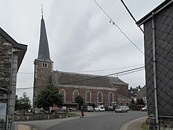
The Saint Michael's church (twisted church tower).
|
||
|
||
| Country | Belgium | |
| Community | French Community | |
| Region | Wallonia | |
| Province | Liège | |
| Arrondissement | Verviers | |
| Area | ||
| • Total | 107.75 km2 (41.60 sq mi) | |
| Population
(2018-01-01)Lua error in Module:Wd at line 1575: attempt to index field 'wikibase' (a nil value).
|
||
| • Total | Lua error in Module:Wd at line 1,575: attempt to index field 'wikibase' (a nil value). | |
| Postal codes |
4845
|
|
| Area codes | 087 | |
| Website | www.jalhay.be | |
Jalhay (pronounced zhal-AY) is a small town in Belgium. It is located in the province of Liège, which is part of Wallonia. Wallonia is the southern, French-speaking region of Belgium.
As of January 1, 2006, Jalhay had about 7,953 people living there. The total area of the municipality is 107.75 square kilometers. This means there were about 74 people for every square kilometer. This number is called the population density.
The municipality of Jalhay includes two main areas. These areas are called districts. They are Jalhay and Sart.
Geography of Jalhay
Jalhay is known for its beautiful natural surroundings. It is located near the High Fens, which is a large nature reserve.
Highest Point in Jalhay
The highest point in the municipality is a place called Baraque Michel. It is located in the High Fens. Baraque Michel reaches a height of 674 meters (about 2,211 feet) above sea level. This makes it one of the highest points in Belgium.
See also

- You can find more information about Jalhay in Spanish here: Jalhay para niños
 | Sharif Bey |
 | Hale Woodruff |
 | Richmond Barthé |
 | Purvis Young |


