James Well, South Australia facts for kids
Quick facts for kids James WellSouth Australia |
|||||||||||||||
|---|---|---|---|---|---|---|---|---|---|---|---|---|---|---|---|

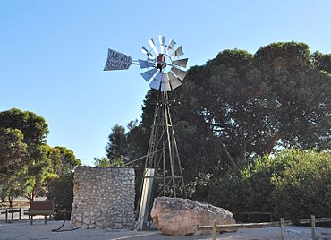
Windmill at James Well
|
|||||||||||||||
| Established | 1999 | ||||||||||||||
| Postcode(s) | 5571 | ||||||||||||||
| Time zone | ACST (UTC+9:30) | ||||||||||||||
| • Summer (DST) | ACST (UTC+10:30) | ||||||||||||||
| Location |
|
||||||||||||||
| LGA(s) | Yorke Peninsula Council | ||||||||||||||
| Region | Yorke and Mid North | ||||||||||||||
| County | Fergusson | ||||||||||||||
| State electorate(s) | Narungga | ||||||||||||||
| Federal Division(s) | Grey | ||||||||||||||
|
|||||||||||||||
|
|||||||||||||||
| Footnotes | Distances Coordinates Climate Adjoining localities |
||||||||||||||
James Well is a small place in South Australia. It is located on the eastern coast of the Yorke Peninsula, right next to Gulf St Vincent. It's about 84 kilometers (52 miles) north-west of Adelaide, the state capital. It is also about 5 kilometers (3 miles) south of Ardrossan.
Contents
About James Well
How James Well Got Its Name
The area known as James Well was officially created in May 1999. It was already a place where people had small holiday homes or "shacks." The name "James Well" was chosen because it was already a well-known local name, though it used to be called "James Wells."
In May 2014, the size of James Well grew. It expanded to include more land on its western side, which was previously part of Sandilands.
Where is James Well Located?
James Well has clear boundaries. To the north, you'll find James Well Road. The Yorke Highway forms its western border. Rogue Point Road is to the south. To the east, it meets the beautiful waters of Gulf St Vincent.
Land Use in James Well
Understanding Land Zones
In 2014, the land in James Well was divided into four main areas, or "zones." These zones run parallel to the coastline, each with a different purpose.
- Coastal Open Space: This area is right along the coast. It's kept open for everyone to enjoy, like for walks or picnics. It also acts as a natural barrier to protect the land from the sea.
- Settlement Zone: This is where people live. It has homes and other buildings, but they are not built too close together.
- Deferred Urban Zone: This land is currently used for farming. However, it's set aside for future growth of the town. This means more homes or buildings might be built here someday.
- Primary Production Zone: This zone is on the western edge of James Well. It's used for activities like farming, which produce raw materials.
Government and Representation
How James Well is Governed
James Well is part of different government areas. This helps manage services and laws for the community.
- Local Government: At the local level, James Well is part of the Yorke Peninsula Council. This council handles things like roads, parks, and local services.
- State Government: For state-level matters, James Well is in the electoral district of Narungga. People living here vote for a representative in the state parliament.
- Federal Government: At the national level, James Well is part of the federal division of Grey. This division elects a representative to the Australian Parliament in Canberra.
 | Janet Taylor Pickett |
 | Synthia Saint James |
 | Howardena Pindell |
 | Faith Ringgold |


