Sandilands, South Australia facts for kids
Quick facts for kids SandilandsSouth Australia |
|||||||||||||||
|---|---|---|---|---|---|---|---|---|---|---|---|---|---|---|---|
| Established | 1999 | ||||||||||||||
| Postcode(s) | 5571 | ||||||||||||||
| Time zone | ACST (UTC+9:30) | ||||||||||||||
| • Summer (DST) | ACST (UTC+10:30) | ||||||||||||||
| Location |
|
||||||||||||||
| LGA(s) | Yorke Peninsula Council | ||||||||||||||
| Region | Yorke and Mid North | ||||||||||||||
| County | Fergusson | ||||||||||||||
| State electorate(s) | Narungga | ||||||||||||||
| Federal Division(s) | Grey | ||||||||||||||
|
|||||||||||||||
|
|||||||||||||||
| Footnotes | Adjoining localities | ||||||||||||||
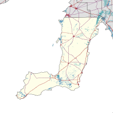
Sandilands is a small area, called a locality, in the state of South Australia, Australia. It is located on the eastern coast of the Yorke Peninsula. This area is right next to Gulf St Vincent, which is a large bay.
Sandilands is about 88 kilometers (55 miles) north-west of Adelaide, the capital city of South Australia. It's also about 18 kilometers (11 miles) south-east of Maitland, which is where the local council's main office is.
About Sandilands
How Sandilands Got Its Name
The name "Sandilands" was officially given to this area in May 1999. It was named after a person called Robert Hamilton Sandilands. He lived in this area during the 1880s.
What People Do in Sandilands
As of 2014, most of the land in Sandilands is used for "primary production." This means people mainly work in farming, fishing, or other activities that get raw materials from nature.
Government and Location
Sandilands is part of a few different government areas.
- It is in the federal division of Grey. This is an area represented by a member of the Australian Parliament.
- It is also in the state electoral district of Narungga. This is an area represented by a member of the South Australian Parliament.
- For local services, Sandilands is part of the Yorke Peninsula Council. This council helps manage things like roads and local facilities in the area.
 | George Robert Carruthers |
 | Patricia Bath |
 | Jan Ernst Matzeliger |
 | Alexander Miles |


