Jerichower Land facts for kids
Quick facts for kids
Jerichower Land
|
||
|---|---|---|
|
||
 |
||
| Country | ||
| State | Saxony-Anhalt | |
| Capital | Burg bei Magdeburg | |
| Area | ||
| • Total | 1,336.63 km2 (516.08 sq mi) | |
| Population
(2002)
|
||
| • Total | 98,897 | |
| • Density | 73.9898/km2 (191.6327/sq mi) | |
| Time zone | UTC+1 (CET) | |
| • Summer (DST) | UTC+2 (CEST) | |
| Vehicle registration | JL | |
| Website | landkreis-jerichower-land.de | |
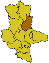
Jerichower Land is a district, also known as a Kreis, located in the north-east part of Saxony-Anhalt, Germany. It's a region with a rich history and beautiful natural areas. The main city and capital of this district is Burg bei Magdeburg.
Contents
History of Jerichower Land
Changes After World War II
After World War II, the old districts of Jerichow, which were part of Prussia, went through some big changes. Some parts of these areas were given to nearby districts like Havelberg and Brandenburg.
The two main Jerichow districts were also given new names. They were renamed after their most important towns. The first Jerichow district became known as Burg, and the second one, Jerichow II, was renamed Genthin.
Merging Districts in Jerichower Land
Later, in 1952, the district of Burg was divided into two smaller parts: Loburg and Burg.
Many years later, in 1994, these two districts, Burg and Loburg, were joined back together. They decided to use the old name, Jerichow. Then, in 2007, six more towns and villages from the former district of Anhalt-Zerbst were added to Jerichower Land. These included Hobeck, Loburg, Lübs, Prödel, Rosian, and Schweinitz.
Origin of the Name
The name "Jerichower Land" comes from a group of early Slavic tribes who lived in this area a long time ago. It's important to know that the name has no connection to the city of Jericho mentioned in the Bible.
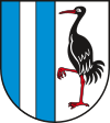
Coat of Arms of Jerichower Land
 |
The coat of arms for Jerichower Land tells a story about the district. The vertical bars you see on the left side of the shield represent the Elbe-Havel canal, which is an important waterway in the region. On the right side, there is a crane. This bird shows the beautiful nature found in the district, as cranes are very common birds there. |
Towns and Communities in Jerichower Land
Jerichower Land is made up of several towns and smaller communities. These are organized into different types of groups to help with local government.
Free Towns and Municipalities
Here are some of the main towns and independent communities in the district:
| Free towns | Free municipalities |
|---|---|
|
|
Administrative Communities (Verwaltungsgemeinschaften)
Many smaller towns and villages in Jerichower Land are grouped together into administrative communities called Verwaltungsgemeinschaften. These groups share some government services. Each group has a main town where its offices are located.
| Verwaltungsgemeinschaften | ||
|---|---|---|
|
|
|
| 1seat of the Verwaltungsgemeinschaft (This is the main town for the administrative community); 2town | ||
See also
 In Spanish: Distrito de Jerichower Land para niños
 | Tommie Smith |
 | Simone Manuel |
 | Shani Davis |
 | Simone Biles |
 | Alice Coachman |

