
Jerrabomberra Wetlands facts for kids
Quick facts for kids Jerrabomberra Wetlands Nature ReserveCanberra, Australian Capital Territory |
|
|---|---|

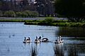
Pelicans at Jerrabomberra Wetlands. Photo by Michael Machonachie
|
|

Jerrabomberra Wetlands Nature Reserve
Location in Australian Capital Territory
|
|
| Gazetted | 1990 |
| Area | 174 hectares |
| Managing authorities | Woodlands and Wetlands Trust, ACT Government |
| Website | Jerrabomberra Wetlands Nature Reserve |
The Jerrabomberra Wetlands is a special watery area in Australia's capital, Canberra. It's one of 13 wetlands in the region. This important place was created when Lake Burley Griffin was filled with water in 1964.
The ACT Parks and Conservation team, along with the Woodlands and Wetlands Trust, help look after it. It's part of the bigger Canberra Nature Park. The wetlands have many water spots like Shoveler Pool, Kelly's Swamp, and parts of the Molonglo River. There are also old river paths called paleochannels, showing where the Molonglo River used to flow.
Jerrabomberra Wetlands is a vital home for many land and water animals. It's listed as a nationally important wetland. This is because it provides a safe place for animals, especially those that are vulnerable. It also offers shelter during tough times like droughts.
You can enjoy many activities here, like nature walks, jogging, and bird watching. Cycling and fishing are also popular. You can even go canoeing or kayaking in Molonglo Reach and Jerrabomberra Reach. The people who manage the wetlands often hold events and educational programs. Nearby places to visit include the Kingston Foreshore and the Royal Military College Duntroon.
Contents
A Look Back in Time
First Peoples of the Wetlands
The land where Jerrabomberra Wetlands now sits has been home to people for at least 25,000 years. This area was very important to the Ngunnawal people. They are the traditional owners of the Canberra region. It was a meeting place for them and other groups like the Ngarigo, Walgalu, Wiradjuri, Gundungurra, and Yuin.
Many old stone tools found near Pialligo show that a large camp once existed here. The Molonglo River was a key source of food. In 1834, a naturalist caught two large fish, each weighing about 6 kilograms, in the river. When the water was low, the river and ponds had smaller fish, turtles, and yabbies. Before European settlement, the area also had kangaroos, wombats, echidnas, birds, snakes, and lizards.
People also gathered food, fibers, and medicines from the diverse plants. Stones and other materials were used to make tools and weapons. These were also traded with other groups.
Jerrabomberra Creek was known by the Ngunnawal people as a spiritual path. It guided visitors from the south to important meeting grounds. The last recorded gathering on the Molonglo River floodplain was in 1862. Today, the Ngunnawal people continue their cultural practices. This includes education and land management, like controlled burn-offs by the Murrumbung Rangers.
European Arrivals
The first written records by European settlers about this area appeared in 1820. They called the region the Limestone Plains because of its rocky outcrops. Early descriptions say the area was mostly grassland with woodlands and forests on the hills.
A large piece of land called Pialligo was bought by Robert Campbell. He used the area near the Molonglo River and Jerrabomberra Creek for sheep farming. Willows, which are now considered a problem plant, were first planted around the Molonglo River in the mid-1800s.
The river and Jerrabomberra Creek often experienced floods and droughts. Severe floods made parts of the river impossible to cross. Droughts turned the water bodies into disconnected ponds. Around 1880, landowners started removing bark from trees to try and lessen the effects of drought.
As more people moved in, farming grew. New farming tools and steam-powered machines helped speed up production. The railway arriving in nearby Queanbeyan in 1887 also helped. Besides farmland, there was also a mill on the Duntroon estate. It was later abandoned and destroyed by weather in 1874.
In 1912, the Australian government took over the area. This happened after Canberra was chosen as the Australian Capital Territory in 1911. During the city's design, someone suggested creating "ornamental waters" using dams. This idea eventually led to the filling of Lake Burley Griffin in 1964. This also permanently raised the water level at Jerrabomberra Wetlands.
World War I Training Ground
During World War I, a part of the old Duntroon estate called Mill Flat was used by the Royal Military College. Soldiers were housed and trained there. They learned about weapons, strategy, and how to build things for the battlefield.
In 2015, old trenches were found during excavations. These were part of the Trench Warfare and Bombing School at Duntroon. The training program used the newest designs and technology. In 1916, it was called "the best system of trenches in Australia." It was the last major trench system built in the country.
Part of the training included building suspension and pontoon bridges. These skills were useful locally in 1925 during a huge flood. Cadets built a pontoon bridge, which helped people get to South Canberra again.
After WWI, the floodplain was divided into farming leases. This was meant to help soldiers returning from the war and boost the local population. These leases later became dairy farms after floods in 1922 and 1925.
Becoming a Nature Reserve
From the mid-1970s, environmental groups started asking for the wetlands to become a nature reserve. They saw its rich wildlife and potential for education and research. They also wanted the public to get involved in protecting the environment.
The Jerrabomberra Wetlands Advisory Group had its first meeting in 1987. A plan for the wetlands was created in 1988. Finally, Jerrabomberra Wetlands Nature Reserve was officially protected in 1990. This was done under the Nature Conservation Act 1980. Before this, some things were already built for visitors. These included bird hides, fences, a bridge, and a car park. These changes were made to allow people to visit without disturbing the wildlife too much.
The wetlands' closeness to the city also affected how it was managed. In 1974, it was noted that a rise in large birds like pelicans and ibis could be a risk to the nearby Canberra Airport. To prevent this, the focus was on keeping many different types of animals and plants. The goal was not just to increase the number of certain bird populations.
In 2011, the ACT government created the Woodlands and Wetlands Trust. This Trust helps manage both Jerrabomberra Wetlands and Mulligans Flat Woodland Sanctuary. Their goal is to support native wildlife and help with environmental research. Volunteers often help by removing weeds, planting trees, and monitoring water quality and birds.
In 2018, Jerrabomberra Wetlands was considered for protection under the Heritage Act 2004. However, it was decided that it was already protected. This was because of the Nature Conservation Act 2014.
Plants and Animals of the Wetlands
Australia has agreements with Japan, China, and Korea to protect birds that migrate. Eight of these migratory bird species use Jerrabomberra Wetlands each season.
About 77 types of waterbirds visit or live in the wetlands. Sixteen of these species even breed here. More than 170 bird species in total have been seen at Jerrabomberra Wetlands. The protected Latham's snipe (Gallinago hardwickii) is one of them. This bird, along with other migratory waders, uses the wetlands as a resting stop. They come from places like America, New Zealand, and parts of Asia. There's an international project focused on understanding the Latham's Snipe and its important homes.
Other endangered bird species found here include the Australasian bittern (Botaurus poiciloptilus) and the Painted-snipe (Rostratula australis). Endangered fish species like the Macquarie perch (Macquaria australasica) and Silver Perch have been seen in the Molonglo River. Some other interesting animals are the platypus (Ornithorhyncus anatinus), the eastern long-necked turtle (Chelodina longicolis), and rakali (Hydromys chrysogaster).
Jerrabomberra Wetlands also has some pest species. Two pest fish are the Common Carp and Eastern Gambusia, also called 'mosquitofish'. Most of the plants growing along the Jerrabomberra Creek shoreline are declared pest plants in the ACT. Major pest plants in the wetlands are willow and wild blackberry. These are considered weeds of national importance. Other pest plants include black alder, robinia, and African boxthorn. The local management team has a program to remove these weeds. They replace them with native plants and trees like casuarinas. This helps improve the habitat and water quality.
Bog bulrush (schoenoplectus mucronatus) also grows at the wetlands. This plant is considered rare in the local area.
Images for kids
-
Pelicans at Jerrabomberra Wetlands. Photo by Michael Machonachie
