Jesús de Santa Bárbara facts for kids
Quick facts for kids
Jesús
|
|
|---|---|
|
District
|
|

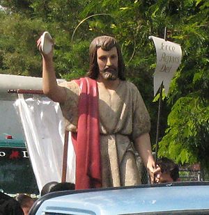
Jesús de Santa Bárbara's ecclesiastical statue of Jesus
|
|
| Country | |
| Province | Heredia |
| Canton | Santa Bárbara |
| Area | |
| • Total | 11.18 km2 (4.32 sq mi) |
| Elevation | 1,160 m (3,810 ft) |
| Population | |
| • Total | 9,603 |
| • Density | 858.9/km2 (2,224.7/sq mi) |
| Demonym(s) | Vecino de Jesús, Jesúseño |
| Time zone | UTC−06:00 |
| Postal code |
40404
|
| Climate | Am |
Jesús, also called Barrio Jesús, is a lively district in the Santa Bárbara area. It is part of the Heredia province in Costa Rica. This district is made up of several big neighborhoods. These include Altagracia, Birrí, Catalina, Común, Cuesta Colorada, La Máquina, Guachipelines, Guaracha, and Ulises.
Contents
History of Jesús
Who Lived in Jesús First?
Long before Spanish settlers arrived, the area of Jesús was home to the Huetares, an indigenous tribe (native people). Their powerful leader was King Cacique Garabito. He ruled over this region.
How Did Jesús Grow?
In the early 1660s, a settler named Joseph de Sandoval Ocampo came to Jesús. He started a cattle farm there. Later, in the late 1700s, three nearby cities grew: Heredia, Barva, and Alajuela. As trade between these cities increased, the Santa Bárbara area, including Jesús, began to develop.
When Did Jesús Become a District?
Jesús officially became a district of Santa Bárbara on December 7, 1848. This happened because Santa Bárbara was named the fourth canton of Heredia Province. This was thanks to the hard work of Gregorio Salazar.
Modern Improvements in Jesús
By 1852, a local resident named Horacio Morales convinced people in Jesús to build a small chapel. By 1885, Jesús had two public schools for children: one for boys and one for girls. Jesús was one of the last districts in Santa Bárbara to get running water, which happened after 1911. It received electricity in 1937.
Geography and Nature in Jesús
What is the Geography of Jesús Like?
Jesús covers an area of about 11.18 square kilometers (4.3 square miles). It is located at an elevation of about 1,160 meters (3,806 feet) above sea level.
Some of the main neighborhoods in Jesús are Calle Solís, Mitad Sur de la Cuesta Colorada, Quebrada la Cruz, and Urbanización Cifuentes. In the northwest part of the district, you'll find neighborhoods like Birrí, La Catalina, and San José de Altagracia.
Rivers and Wildlife in Jesús
Because Jesús is in a mountainous area, the National Risk Prevention Commission says it's a high-risk zone. This means there can sometimes be landslides (when rocks and earth slide down a hill) and flooding (when too much water covers the land).
Several large rivers flow through Jesús. These include Quebrada Burros, Quebrada Birrí, Río Porrosati, and Quebrada Cruz. Over 60 different kinds of birds have been seen living in Jesús!
Economy of Jesús
What Does Jesús Produce?
The main part of Jesús's economy is agriculture (farming). They grow a lot of coffee. In 1973, Jesús produced 1,810 kilograms (about 4,000 pounds) of coffee! Jesús is also a big producer of sugarcane. There is even an active recycling group in the district.
Businesses and Tourism in Jesús
Jesús has many different businesses. You can find supermarkets, restaurants, and small corner stores. The district also has a growing tourism industry (businesses that serve visitors).
- Hotel Rosa Blanca is a small, fancy hotel.
- Hotel Monte Campana, located in Birrí, offers ranches, swimming pools, and other fun activities.
- La Catalina is another hotel in the district.
For tourists who enjoy fishing, there are businesses with lakes and rivers stocked with fish. Also, Café Britt, a well-known coffee company, has a distribution center near central Jesús.
Education and Public Services in Jesús
Healthcare and Community Services
An EBAIS (Equipo Básico de Atención Integral en Salud) is located in Jesús. This is a basic medical care center that helps both residents and visitors. The Catholic Church also serves the community through the Archdiocese of Alajuela.
Schools in Jesús
Jesús has three elementary schools:
- Alfredo Volio Jiménez (in Birrí)
- Alfredo González Flores (on Highway 126)
- Escuela Jesús (in central Jesús)
Most students from Jesús go to Colegio Santa Bárbara High School. However, they can also choose to attend high schools in Barva or Heredia. Jesús is also home to a private language school called The Amistad Institute. It has a large campus close to the center of Jesús.
Population of Jesús
| Historical population | |||
|---|---|---|---|
| Census | Pop. | %± | |
| 1883 | 636 | — | |
| 1892 | 690 | 8.5% | |
| 1927 | 837 | 21.3% | |
| 1950 | 945 | 12.9% | |
| 1963 | 1,556 | 64.7% | |
| 1973 | 2,144 | 37.8% | |
| 1984 | 3,717 | 73.4% | |
| 2000 | 7,585 | 104.1% | |
| 2011 | 9,603 | 26.6% | |
|
Instituto Nacional de Estadística y Censos |
|||
According to the 2011 census, Jesús had a population of 9,603 people.
Transportation in Jesús
Road Transportation
The district of Jesús is connected by the following main roads:
See also
 In Spanish: Jesús de Santa Bárbara para niños
 | Sharif Bey |
 | Hale Woodruff |
 | Richmond Barthé |
 | Purvis Young |


